Paseo de la Reforma
It was supposed to be a private road. In 1864, Emperor Maximilian I commissioned a grand boulevard to link the National Palace in downtown Mexico City with his residence at Chapultepec Castle, modeling it after the Champs-Elysées in Paris and the Ringstrasse in Vienna. He named it Paseo de la Emperatriz -- Promenade of the Empress -- in honor of his wife, Carlota. Three years later, Maximilian was executed by firing squad. The boulevard survived, renamed for the liberal reform movement that ended his empire.
An Emperor's Road on a Lake Bed
The engineers who built the Paseo faced an unlikely problem: the ground itself. Mexico City sits on the former bed of Lake Texcoco, and critics argued that the soft, salty soil could not support the lush European-style landscaping Maximilian envisioned. The city government and landowners along the route pushed back, warning that the fragile reclaimed lake bed would swallow the project. Austrian engineers Alois Bolland and Ferdinand von Rosenzweig pressed ahead regardless, assigned to build the boulevard under the supervision of the Ministry of Development, Colonization, Industry and Commerce. The original design called for two vehicle paths nine meters wide each, a central island, and two pedestrian promenades lined with ornamental trees. Of the planned 3.15-kilometer route, only a portion was completed between 1864 and 1865 -- a road twenty meters wide, enormous for its era. The route committee had originally wanted six boulevards radiating from the Zocalo, but that would have required demolishing large swaths of the city, as Haussmann had done in Paris. Instead, the Paseo began at the western edge of town, where Avenida Bucareli meets Avenida Juarez, and ran to the foot of Chapultepec Hill. After the fall of the empire, the boulevard was renamed Paseo de la Reforma, and subsequent presidents continued its expansion. What had been an emperor's vanity project became public infrastructure.
Monuments in Traffic Circles
Walking the length of Reforma today means passing through Mexico's history in bronze and stone. The avenue's major traffic circles hold its most iconic monuments: a statue of Columbus, a tribute to the last Aztec emperor Cuauhtemoc, and the Angel of Independence -- "El Angel" -- erected in 1910 to mark the centennial of Mexican independence. Along the boulevard's flanks, a parade of smaller statues honors the liberal politicians, journalists, and thinkers who shaped the republic. Guadalupe Victoria, the first president. Melchor Ocampo, a radical liberal murdered during the War of the Reform. Ignacio Manuel Altamirano, an intellectual and writer of indigenous origins. The statues overwhelmingly celebrate the liberal side of Mexican history -- the victors of the Reform War wrote their names into the avenue's very landscape.
Glass, Steel, and Sunday Bicycles
The Paseo's character shifts as it moves through the city. In the Zona Rosa and around the Torre Mayor, it is a canyon of glass and steel, home to some of Mexico's tallest buildings, luxury hotels, and corporate headquarters. Further northeast, it reaches Tlatelolco and the Plaza de las Tres Culturas before splitting into the calzadas that lead to the Basilica of Guadalupe. To the west, past Chapultepec Park and the affluent neighborhood of Lomas de Chapultepec, it widens into something more highway than promenade. But every Sunday from 8 a.m. to 2 p.m., the main downtown stretch closes to motor vehicles as part of the Paseo Dominical Muevete en Bici program. The boulevard that an emperor built for his private carriage becomes, for six hours, a river of bicycles.
Where the Nation Gathers
Reforma is where Mexico City goes to feel something collectively. When the national football team wins at the World Cup, the celebrations converge on the Angel of Independence roundabout. When citizens march in protest, the route typically runs from the Angel to the Zocalo, or the reverse -- a straight line between the symbol of independence and the seat of government. Mexico City Pride parades down its length annually. The boulevard functions as both stage and commons, a place where private grievances become public spectacle and public victories become personal memory. In 2003, the city government launched a renewal program that included new pink quarry sidewalks, updated lighting, and redesigned gardens along the avenue's length. The Reforma 222 mixed-use development, opened in 2007, brought shopping and dining to the commercial core. New towers continue to rise above it, but the avenue's identity remains rooted less in its architecture than in what happens at street level -- the marches, the celebrations, the Sunday cyclists claiming the lanes an emperor once reserved for himself.
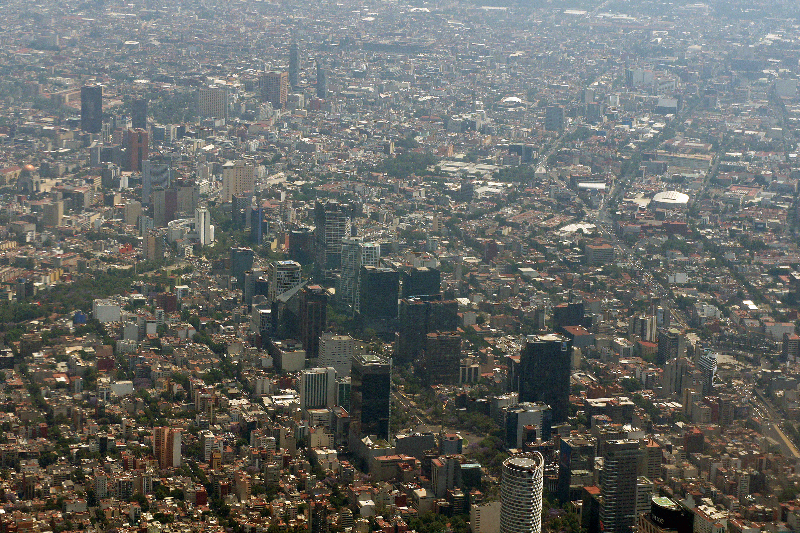
From the Air
Located at 19.4344N, 99.1519W, Paseo de la Reforma runs diagonally northwest-to-southeast across central Mexico City. From the air, it is one of the most recognizable features of the city grid -- a broad diagonal line cutting through the otherwise orthogonal street pattern, connecting Chapultepec Park to the downtown core near the Zocalo. The Angel of Independence monument is visible as a golden figure atop a tall column at a major traffic circle. Nearest major airport is Mexico City International (MMMX/MEX), approximately 10 km east. Best viewed at 3,000-5,000 ft AGL for the full length of the avenue.