Patagonia
Patagonia is less a place than a state of mind - a region so vast and wild that it has come to symbolize the edge of the known world. Straddling southern Chile and Argentina, this territory of glaciers, mountains, and endless steppe stretches from roughly the 40th parallel to the southern tip of South America. The Chilean side harbors some of Earth's most spectacular scenery: the granite spires of Torres del Paine, the calving glaciers of the Southern Ice Field, the labyrinthine fjords of the Carretera Austral. The wind here is legendary, capable of knocking hikers off their feet and driving horizontal rain through the most waterproof gear. But those who brave the elements discover landscapes that justify every superlative - a reminder that true wilderness still exists for those willing to reach it.
Torres del Paine
No image better captures Patagonia than the Torres del Paine - three granite towers rising vertically from the landscape like monuments to the sublime. Torres del Paine National Park, established in 1959, encompasses 1,800 square kilometers of mountains, glaciers, lakes, and rivers in Chile's far south. The famous W Trek covers approximately 80 kilometers over four to five days, visiting the Torres base, the French Valley, and Grey Glacier. The longer O Circuit adds the park's wilder backside for those seeking solitude. Wildlife sightings include guanacos (wild relatives of llamas), Andean condors, and the elusive puma - the park hosts one of the world's highest puma concentrations. The Cuernos del Paine, horn-shaped peaks capped with black sedimentary rock over light granite, provide another iconic silhouette. Weather here changes by the hour; clear mornings yield to afternoon storms with startling regularity.
The Carretera Austral
The Carretera Austral ranks among the world's great road trips - 1,200 kilometers of gravel and pavement threading through Chilean Patagonia from Puerto Montt to Villa O'Higgins. Completed only in the 1980s under Pinochet (who sought to connect remote regions before Argentina could claim them), the highway passes through landscapes that seem too dramatic to be real: hanging glaciers, emerald rivers, volcanic peaks, temperate rainforest. Key stops include the marble caves of General Carrera Lake, the hiking around Cerro Castillo, and the hot springs scattered throughout the region. Ferry crossings interrupt the route in several places, adding to the adventure. The road dead-ends at Villa O'Higgins, from where hikers and cyclists can cross into Argentina via a route involving boats and trails. Cell service is rare; self-sufficiency is essential.
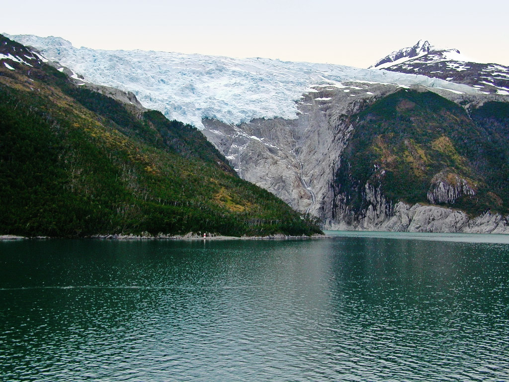
Ice Fields and Glaciers
The Southern Patagonian Ice Field is the world's third-largest continental ice mass, exceeded only by Antarctica and Greenland. From this frozen plateau, glaciers descend into valleys and lakes throughout the region. On the Chilean side, Grey Glacier in Torres del Paine calves icebergs into the lake of the same name, which float past kayakers in surreal processions of blue ice. The Northern Patagonian Ice Field feeds glaciers accessible from the Carretera Austral, including the spectacular Exploradores Glacier near Puerto Rio Tranquilo. Climate change has accelerated retreat throughout the region; some glaciers have lost kilometers of length within decades. Trekking onto the ice requires guides and crampons but offers an unforgettable experience of walking through a landscape that has remained frozen for millennia - and may not remain so much longer.
Patagonian Wind and Weather
Nothing prepares visitors for Patagonian wind. Storms barrel in from the Pacific with little warning, funneling through valleys and over passes with sustained speeds that can exceed 100 kilometers per hour. Tents must be anchored with rocks; hiking plans must remain flexible. The region sits in the 'roaring forties' and 'furious fifties' - latitudes where westerly winds circle the globe almost unimpeded by land. Precipitation varies dramatically: the western side, facing the Pacific, receives several meters of rain annually, supporting dense temperate rainforest. The eastern steppe, in the rain shadow of the Andes, receives barely 200 millimeters and supports only tough grasses and thorny shrubs. Summer (December through February) offers the longest days and mildest weather, though no season guarantees good conditions. Layering is essential; all four seasons can occur in a single day.
Getting There and Around
Chilean Patagonia requires commitment to reach. Torres del Paine is accessed via Punta Arenas or Puerto Natales, both served by flights from Santiago (over three hours). The Carretera Austral begins at Puerto Montt, reachable by air or by overnight ferry from the Lake District. Ferry routes from Puerto Montt to various points along the coast offer scenic alternatives to driving. Within the region, rental vehicles (ideally 4WD) provide flexibility, though fuel stations are sparse and distances long. Refugios and campsites in Torres del Paine require advance booking during peak season (December-February). The shoulder seasons of November and March offer fewer crowds and sometimes better weather, though more closures and reduced services. However you arrive, Patagonia rewards patience - distances are vast, roads are slow, and the landscape demands time to absorb.
From the Air
Located between approximately 41°S and 55°S along the Chilean coast and Andes. The region is characterized by the dramatic granite peaks of Torres del Paine (51°S, 73°W), extensive ice fields, and intricate fjord systems. Punta Arenas (PUQ) serves as the main gateway to Torres del Paine; Balmaceda (BBA) provides access to the northern Carretera Austral region. The Southern Patagonian Ice Field appears from altitude as an expanse of white between the jagged Andes peaks. The maze of channels and islands along the Pacific coast creates one of the most complex coastlines on Earth.