Path of 100 Towers (Sardinia)
In 2013, a Sardinian named Nicola Melis walked the Camino de Santiago with his father and came home with an idea: why not create something similar for Sardinia? Four years later, working with Roberto Contu and Stefano Paderi, he launched the Cammino 100 Torri -- the Path of 100 Towers. At 1,284 kilometers, it is the longest trek in Italy, a counterclockwise loop that begins and ends in Cagliari, following the island's entire coastline past 105 historical watchtowers. Completing the circuit takes 45 to 60 days. But the path connects more than distance; it threads together four centuries of coastal defense, the wild ecology of the Mediterranean, and the kind of landscapes that made Spain want to protect Sardinia in the first place.
The Captain on Horseback
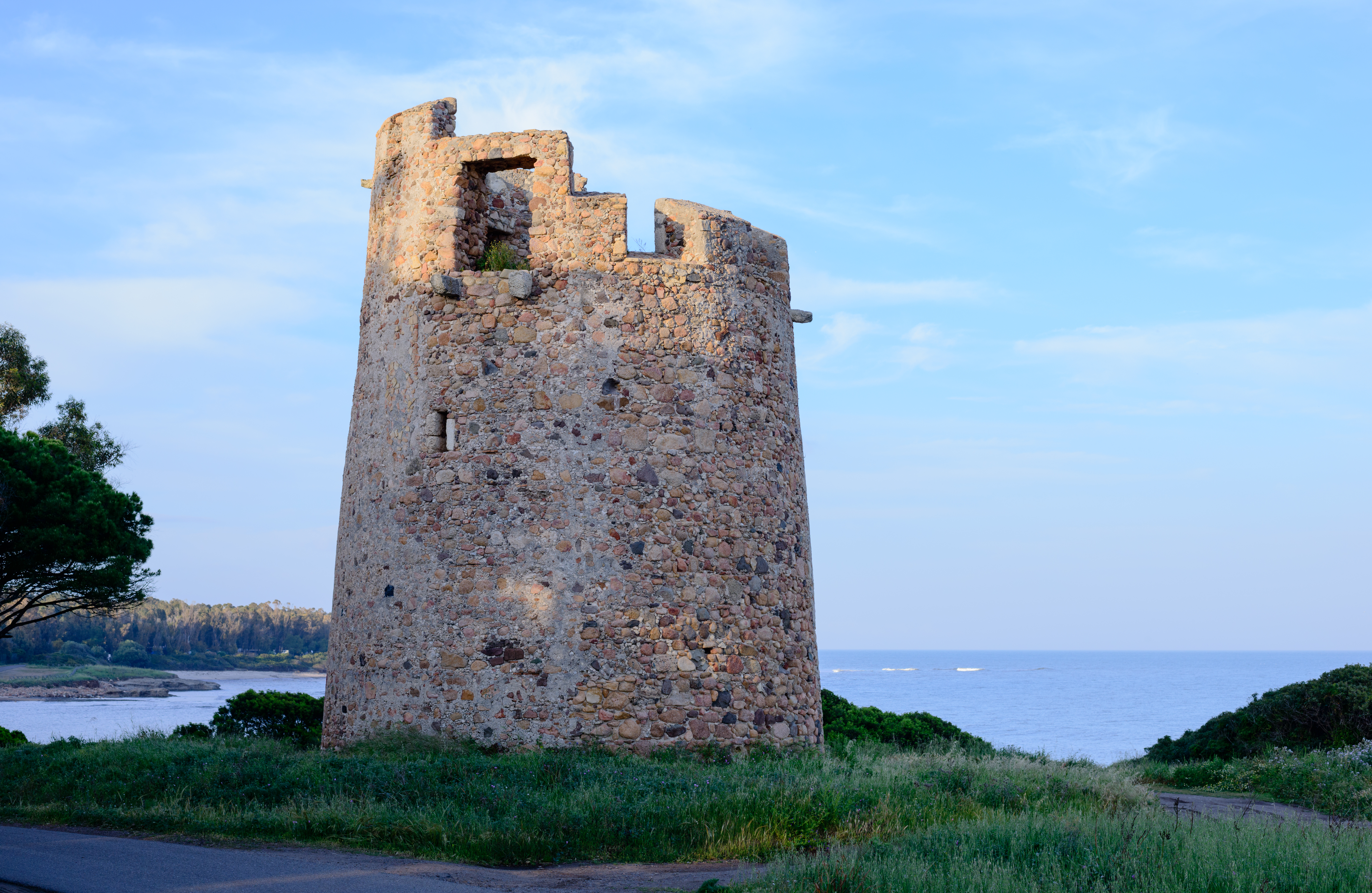
The towers that give the path its name trace back to a single mission. Around 1600, King Philip II of Spain sent Captain Marco Antonio Camos from Iglesias to circumnavigate Sardinia on horseback, surveying every cove, headland, and harbor. His orders: design a defensive system of coastal towers to protect the island from Saracen raiders. Camos documented where to source building materials, how many soldiers each tower would need, and who would pay for supplies. The result was a chain of watchtowers in three classes -- the massive Torre de Armas at 14 meters tall and 17 meters wide, armed with cannons and commanded by a captain; the mid-sized Senzillas at 13 meters; and the small Torrezillas at just 5 meters, perched in inaccessible spots as observation posts. Some survive in excellent condition. Others are crumbling ruins. A few have been converted into lighthouses or private homes.
Eight Streets, One Island
The path divides into eight named stages, each with its own character. The Street of Angels, the shortest at 62 kilometers, begins at the Tower of Quarta Regia and follows Cagliari's eight-kilometer Poetto beach before heading south to Villasimius. The Street Sarcapos stretches 143 kilometers along the Sarrabus coast, crossing the crystal-clear Flumendosa River through vegetation thick with myrtle, mastic, and holm oaks. In the northeast, the Street Gallura winds through jagged granite coastline and islands -- Tavolara and the Maddalena archipelago -- that draw tourists from around the world. The Street Catalana, at 238 kilometers, is one of the longest sections, passing medieval villages like Castelsardo, Alghero, and Bosa along wide beaches and rocky coves. Each stage demands between a few days and two weeks, and walkers collect a testimonium stamp at each one, filling a Pilgrim Passport modeled on the Camino de Santiago credential.
Wild Edges
The path stays roughly two kilometers from the shore, close enough to see the sea but far enough to cross the ecological zones that make Sardinia's coast distinctive. Mediterranean scrub dominates the terrain -- myrtle, laurel, rosemary, juniper, and genisteae adapted to strong winds and seasonal drought. Fallow deer and wild boar move through the vegetation, and vipers sun themselves on warm rocks. Where the path crosses lagoons, the ecology shifts to shallow bodies of fresh and salt water separated from the sea by sand dunes. These wetlands harbor marsh samphire, sea blite, and stands of reed and cattail, along with the birds and small mammals that depend on them. The landscape is sensitive to desertification and vulnerable to wildfire -- a Mediterranean biome walking the line between lush growth and arid collapse.
Walking a Country's Identity
The Path of 100 Towers has been recognized by the Register of Paths of Sardinia and Religious and Spiritual Itineraries as representing Sardinian identity, spirit, and culture. The route passes more than 500 religious sites -- sanctuaries and churches -- in addition to the towers themselves, making it a journey through the island's military and spiritual history simultaneously. The oldest tower on the path, the Tower of Saint Elia, dates to 1282 and stands as the first coastal watchtower ever built in Sardinia. It was used not only for defense but to guide boats safely into port, a dual purpose that captures the tension at the heart of the island's relationship with the sea: the same water that brought raiders also brought trade, prosperity, and connection. Walking the full circuit means tracing that tension across every kilometer of Sardinia's coast.
From the Air
The path begins and ends in Cagliari (39.21N, 9.12E) and follows Sardinia's entire 1,284 km coastline. From the air, the coastal watchtowers are visible at intervals along the shore. Best viewed at 5,000-10,000 feet to trace the coastline and spot tower ruins on promontories. Key waypoints include Villasimius (southeast), the Gallura coast (northeast), Castelsardo and Alghero (northwest). Nearest airport: Cagliari-Elmas (LIEE). The Poetto beach, the path's starting stretch, is one of Cagliari's most recognizable features from the air.