Penang Strait
On the morning of October 28, 1914, a German cruiser flying a false British flag slipped through the pre-dawn darkness of a narrow Malaysian waterway and opened fire on a Russian warship at anchor. The SMS Emden's raid on the Penang Strait lasted barely an hour, but it underscored what traders, navies, and empires had understood for more than a century: this 11-kilometer ribbon of water between Penang Island and the Malay Peninsula is a chokepoint that matters far beyond its modest width.
Where Empires Read the Currents
The Penang Strait divides neatly into two passages. North of the rocky promontory where George Town sits, the North Channel opens toward the Andaman Sea. South of it, the wider South Channel runs between the island's southeastern coast and the mainland territory of Seberang Perai. Both ends funnel into the Strait of Malacca, one of the busiest maritime corridors on Earth. Captain Francis Light recognized the strategic value of this geography when he claimed Penang for the British East India Company in 1786, establishing George Town as a free port to rival Dutch-controlled Malacca. The gamble worked. Within decades, the strait hummed with merchant traffic, and the waterfront along Weld Quay grew into a deepwater harbor where steamships and sailing junks shared anchorage. Rivers feed the strait from both sides - the Pinang and Gelugor from the island, the Perai, Muda, and Juru from the mainland - carrying sediment that has shaped the channel's depths and currents for millennia.
An Island in the Channel
Scattered through the South Channel lie a handful of small islands, the largest being Jerejak Island off Penang's southeastern coast. Densely forested and eerily quiet today, Jerejak carried a very different reputation for most of the 20th century. The British established a leper asylum there, isolating patients on an island that was close enough to see the mainland but far enough to enforce quarantine. After the asylum closed, the buildings were repurposed as a maximum security prison - a transformation that says something about how colonial authorities viewed both disease and detention. The prison itself shut down in 1993, and the island has since drifted into a kind of limbo, its overgrown ruins drawing occasional visitors but no permanent residents. Nearby, the smaller Aman Island and Gedung Island sit off the southern coast of Seberang Perai, while artificial islets created during the construction of the Penang Bridge in the 1980s add human-made geometry to the channel's natural contours.
Shots Across the Water
The Emden's 1914 raid remains the strait's most dramatic military episode. Disguised with a false fourth funnel to resemble a British warship, the German light cruiser entered the channel at dawn and torpedoed the Russian cruiser Zhemchug before the crew could respond. The Emden then turned northwest toward the open Malacca Strait, sinking the French destroyer Mousquet on its way out. The Battle of Penang, as it came to be known, was brief but shocking - a reminder that even waters far from Europe's Western Front could become theaters of the Great War. Three decades later, the strait saw conflict again when Allied bombers laid air-dropped mines across the channel to disrupt Japanese merchant shipping in the final months of World War II. The waterway's strategic value has always been inseparable from its vulnerability.
Bridges, Ferries, and Power Lines
For most of its history, the only way across the Penang Strait was by boat. The ferry service that still runs between George Town and Penang Sentral on the mainland carries an echo of that older rhythm, threading directly into the city center rather than bypassing it. But two bridges now dominate the crossing. The Penang Bridge, completed in 1985, stretches 13.5 kilometers between Gelugor on the island and Perai on the mainland, its sweeping curve a defining feature of the strait's visual identity. In 2014, the 24-kilometer Second Penang Bridge opened further south, connecting Batu Maung to Batu Kawan and claiming the title of longest bridge in Southeast Asia at the time -- a title since taken by Brunei's Sultan Haji Omar Ali Saifuddien Bridge when it opened in 2020. The strait's latest infrastructure project carries not vehicles but electricity: a RM500 million cross-strait transmission line initiated in 2022, designed to deliver 2,000 megawatts from the national grid. Six of its 31 monopole towers feature a betel nut design, turning engineering necessity into architectural statement alongside the bridges.
A Working Waterway
The port geography has shifted over the centuries, but the strait's commercial heartbeat never stopped. Until the 1970s, cargo ships docked at Weld Quay in George Town, where late-19th-century land reclamation had deepened the waterfront. In 1974, the heavy lifting moved across the channel to Butterworth, where the Port of Penang now handles over 1.2 million TEU of container cargo annually. George Town kept its role as a cruise gateway: Swettenham Pier recorded 145 port calls in 2015 alone, the highest in Malaysia. The strait's currents remain powerful and unpredictable, a fact tragically demonstrated in January 2010 when a dragon boat capsized during a collision caused by strong currents, killing six paddlers. The incident sparked debate about whether the strait's busy traffic, monsoon swells, and tidal forces make it suitable for water sports at all - a question that speaks to the tension between a waterway's commercial identity and the community that lives along its shores.
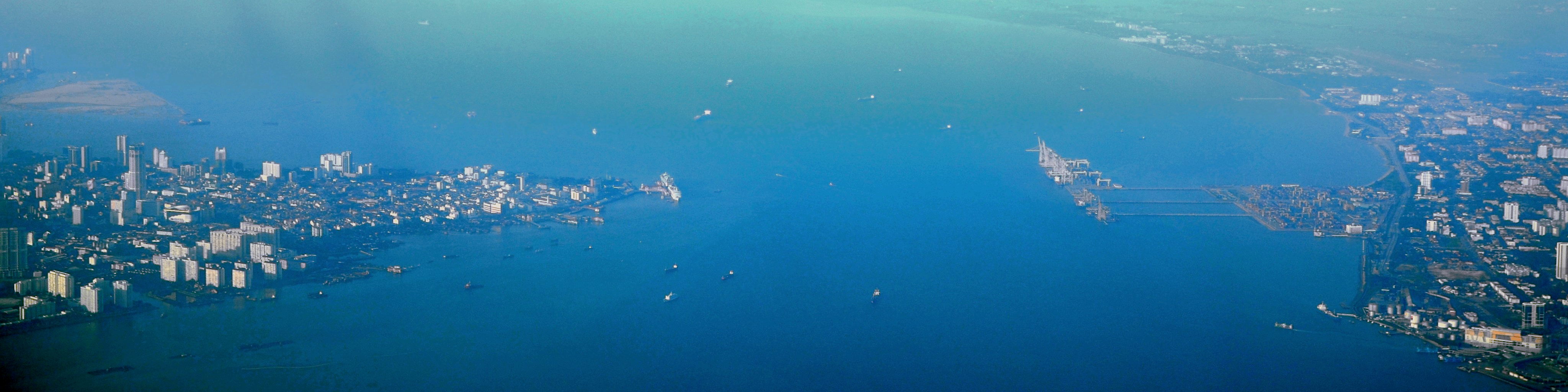
From the Air
The Penang Strait is centered at approximately 5.34°N, 100.35°E, visible as the narrow channel separating the teardrop-shaped Penang Island from the mainland. At cruising altitude, both the Penang Bridge and the Second Penang Bridge are clearly visible spanning the South Channel. The nearest major airport is Penang International Airport (WMKP) on the island's southeastern coast at Bayan Lepas. Butterworth Air Force Base (WMKB) sits on the mainland side. The strait aligns roughly north-south, and the two bridges provide excellent visual reference points for orientation.