Penghu
The Portuguese called them the Pescadores - the Islands of the Fishermen - and the name stuck for centuries among European mapmakers who charted these waters without ever quite controlling them. Penghu is an archipelago of 90 islands in the Taiwan Strait, closer to Taiwan than to mainland China, though both governments have claimed them with equal conviction. What makes Penghu remarkable is not the geopolitics but the stubborn beauty of the place itself: volcanic basalt columns rising from turquoise shallows, wind-scoured landscapes bristling with agave and prickly-pear cactus, coral-sand beaches that crunch underfoot, and a recorded history that predates Taiwan's own by several centuries.
Han Chinese fishermen from southeastern Fujian sailed here and established communities as early as the 9th or 10th century, during the Song Dynasty. By the time the Mongol Empire formalized military control, Penghu was already a functioning outpost of Chinese civilization - a stepping stone between the continent and the wild island of Formosa to the east.
The Dutch, the Ming, and the Fort That Moved
Penghu's strategic position made it irresistible to every naval power that entered the South China Sea. In 1604, the Dutch East India Company commander Wijbrand van Warwijck withdrew to the Pescadores after failing to seize Macau from the Portuguese. He sent messengers to the Ming Empire requesting trade permissions. The Ming refused and dispatched General Shen Yourong to expel the Dutch. The event was recorded on a stone tablet - still visible today at the Tianhou Temple in Magong - that reads, in effect, "Shen Yourong expelled Wijbrand and his people."
The Dutch returned in 1622, building a fort at Fengkuei on what is now called Snake Head Hill. Two years and eight months of siege later, the Ming forced them out again. The terms were precise: the Dutch could exploit Formosa, which was still effectively no man's land, but they had to destroy their Penghu fort completely. Cornelis Reijersen agreed. Every building material from the demolished fort was shipped to Formosa and used to construct Fort Zeelandia - the structure that would become the foundation of Dutch colonial Taiwan. Penghu's loss was literally Taiwan's gain.
Columns of Fire, Gardens of Wind
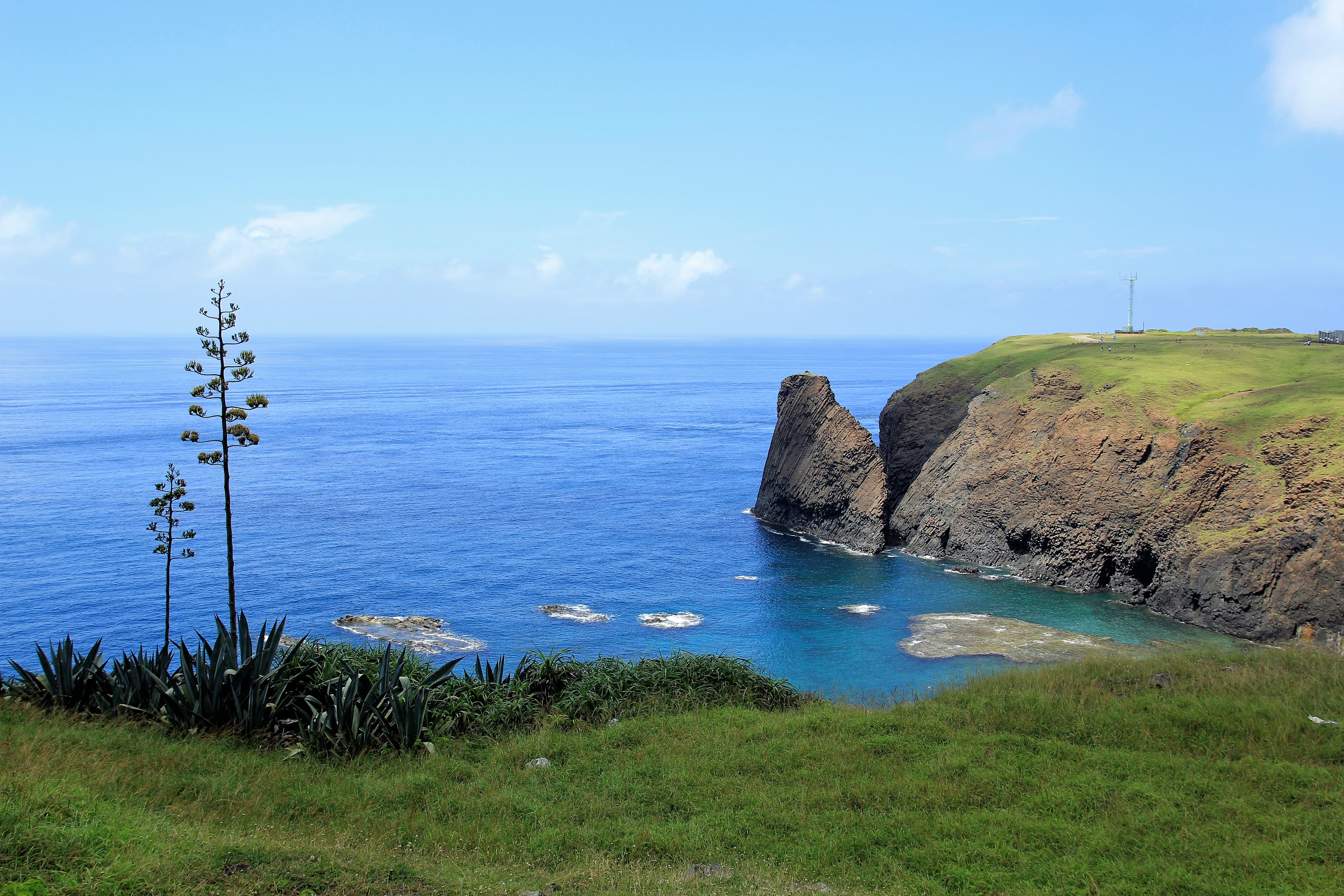
Penghu was born from volcanoes. The archipelago's low-lying islands are composed of basalt, and along the coastlines this ancient stone reveals itself in spectacular columnar formations - hexagonal pillars stacked like organ pipes, carved by cooling lava and polished by centuries of wind and salt spray. The columns are famous across Taiwan, drawing geology enthusiasts and photographers who come to witness stone that looks engineered but is entirely natural.
The landscape above the basalt is spare and tough. Penghu is drier than most of Taiwan, its flat terrain offering no shelter from winds that howl through the strait during winter months. Farmers have planted hardy evergreen trees as windbreaks, but the dominant vegetation remains agave and prickly-pear cactus - plants that thrive on neglect and punishing weather. The archipelago's 90 islands spread across a wide stretch of sea, but most are uninhabited. Seven administrative districts encompass one city, Magong, and six townships. The southern islets of Qimei and Wang'an sit isolated in open ocean, reachable only when the winds permit.
Mazu's Temple and the Four-Eyed Well
Magong, Penghu's only city, anchors its identity to the sea goddess. The Tianhou Temple, where sailors and fishermen have prayed to Mazu for safe passage for centuries, is the spiritual heart of the archipelago. Nearby sits the Four Eyes Well, a 400-year-old freshwater well with four openings designed so multiple families could draw water simultaneously - a practical solution to scarcity that has become one of Penghu's most photographed sites. The old street surrounding these sites has been tastefully restored, its coral-stone walls and narrow lanes evoking the fishing village that Magong once was before it became a county seat.
Beyond the city, the islands reward wandering. Erkan Village on Xiyu Island preserves traditional courtyard houses built from coral and local stone, their walls thick enough to resist the winter gales. Aimen Village, walking distance from Magong's airport, leads down a signposted lane lined with coral fences to a beach of fine sand. The archipelago's two marine national parks protect waters where sea turtles nest and the Blue Cave - a sea cavern accessible only by boat tour - glows with refracted light in the right conditions.
The Strait Between Powers
Penghu has spent its entire recorded history caught between larger forces. Song Dynasty fishermen, Mongol garrisons, Ming generals, Dutch traders, Qing administrators, Japanese colonizers - each left their mark on an archipelago too strategically valuable to ignore and too small to resist on its own terms. Military bases still dot the islands, a reminder that the Taiwan Strait remains one of the most contested waterways on Earth.
But the military presence is mostly invisible to visitors, who encounter instead the Penghu that exists between the geopolitics: scooter rentals and bicycle paths along the seashore, seafood restaurants where the catch comes in hours before the meal, and beaches where the sand is coral-white and the water is the saturated turquoise that photographs cannot quite capture. Hou Hsiao-Hsien filmed "The Boys from Fengkuei" here in 1983, capturing the restless boredom of young men on a beautiful island with nothing to do. The film's tension - between beauty and isolation, between staying and leaving - still describes Penghu honestly. The islands are gorgeous and remote, ancient and overlooked, shaped by 1,100 years of recorded history into a way of life built around wind, water, and the patience both require.
From the Air
Located at 23.57°N, 119.58°E in the Taiwan Strait, the Penghu archipelago comprises 90 islands scattered between Taiwan and mainland China, approximately 50km off Taiwan's western coast. Magong Airport (RCQC/MZG) on the main island has a 3,000m runway and handles regular flights from Taipei, Taichung, Kaohsiung, Tainan, and Jiayi. From altitude, the archipelago is distinctive: flat, low-lying islands connected by bridges (the main group of Magong, Huxi, Baisha, and Xiyu is linked), surrounded by shallow turquoise water that contrasts sharply with the deeper blue of the Taiwan Strait. Basalt columnar formations along the coastlines are visible at lower altitudes. The Great Bridge connecting Baisha and Xiyu is a prominent landmark. Qimei and Wang'an islands sit roughly 40km to the south. Winter winds in the strait can be extreme (October-February), often exceeding 30 knots and cancelling inter-island ferry service. Summer months bring calmer seas but high humidity and temperatures above 30°C.