Pensacola Dam
Fifty-one concrete arches march across the Grand River in Mayes County, Oklahoma, forming the longest multiple-arch dam in the world. The Pensacola Dam is a monument to Depression-era determination -- conceived by a teenager who left Oklahoma at 16 to study dam construction in India and Africa, funded by Franklin Roosevelt's New Deal, and built by 3,000 workers who earned about $16 a week. When it was completed in 1940, it created Grand Lake o' the Cherokees and became Oklahoma's first hydroelectric power plant, transforming a flood-prone river valley into an engine of electricity and recreation.
A Dream Built on Borrowed Money
The story of Pensacola Dam begins with Henry Holderman, who left Oklahoma as a teenager to work on dam projects in India and Africa. When he returned, he sold his land holdings and borrowed money from friends to purchase rights to the dam sites he had prospected along the Grand River. Supporters in Washington argued the dam would provide hydroelectric power and stimulate Oklahoma's battered economy, but local energy companies fiercely opposed the prospect of a state-run electric utility. The Great Depression broke the deadlock. In 1928, Representative Everette B. Howard secured $5,000 for the U.S. Army Corps of Engineers to survey the river. The resulting study estimated $6.2 million for a flood-control-only dam. Oklahoma created the Grand River Dam Authority on January 10, 1935, and in September 1937, President Roosevelt approved $20 million through the Public Works Administration for a far more ambitious project: a dam built for hydroelectric power, flood control, and recreation.
Fifty-One Arches
Pensacola Dam is a multiple-arch buttress design consisting of 51 arches, a main spillway, and two auxiliary spillways. The Massman Construction Company of Kansas City, Missouri, built the major superstructures. Thousands of workers relocated to the area before construction began, and 3,000 ultimately labored on the project. The two-lane State Highway 28 crosses over the top of the dam and a bridge spanning the main spillway. The dam's power station sits at the base of its western end, housing six 20-megawatt Francis turbine generators -- the original four from construction plus two added in the 1950s. The Federal Power Commission granted the first license in 1939. The reservoir it created, Grand Lake o' the Cherokees, stretches far upstream with extensive shoreline, transforming the northeastern Oklahoma landscape.
Power Versus Nature
Managing Pensacola Dam means balancing competing demands: flood control, hydroelectric generation, recreation, and environmental conservation. When the reservoir's elevation exceeds certain levels, the U.S. Army Corps of Engineers takes over discharge control. In hot mid-summer periods, minimal releases can reduce dissolved oxygen levels in the river downstream, with devastating consequences -- in July 2007, at least 5,000 fish died below the dam. Inconsistent releases have drawn criticism from state legislators and environmental advocates alike. The GRDA has explored aeration devices and monitoring studies, and the 1992 federal license required plans to bring dissolved oxygen levels in line with state water quality standards. The tension between generating electricity and protecting the river ecosystem remains an ongoing challenge.
A New Deal Legacy on the Grand
Between Memorial Day and Labor Day, the Grand River Dam Authority offers free tours of the dam, and visitation has been steadily growing -- more than 9,000 people came in 2010 alone. The Ecosystems and Education Center, completed that same year, serves as both a water and fish monitoring research lab and a public education facility about hydropower and water safety. From the air, the dam is unmistakable: a long, rhythmic line of concrete arches stretching between the towns of Disney and Langley, holding back a lake that remade the economy of northeastern Oklahoma. It stands as one of the New Deal's most enduring physical achievements in the American heartland -- proof that ambition, federal funding, and 3,000 pairs of hands can reshape a landscape.
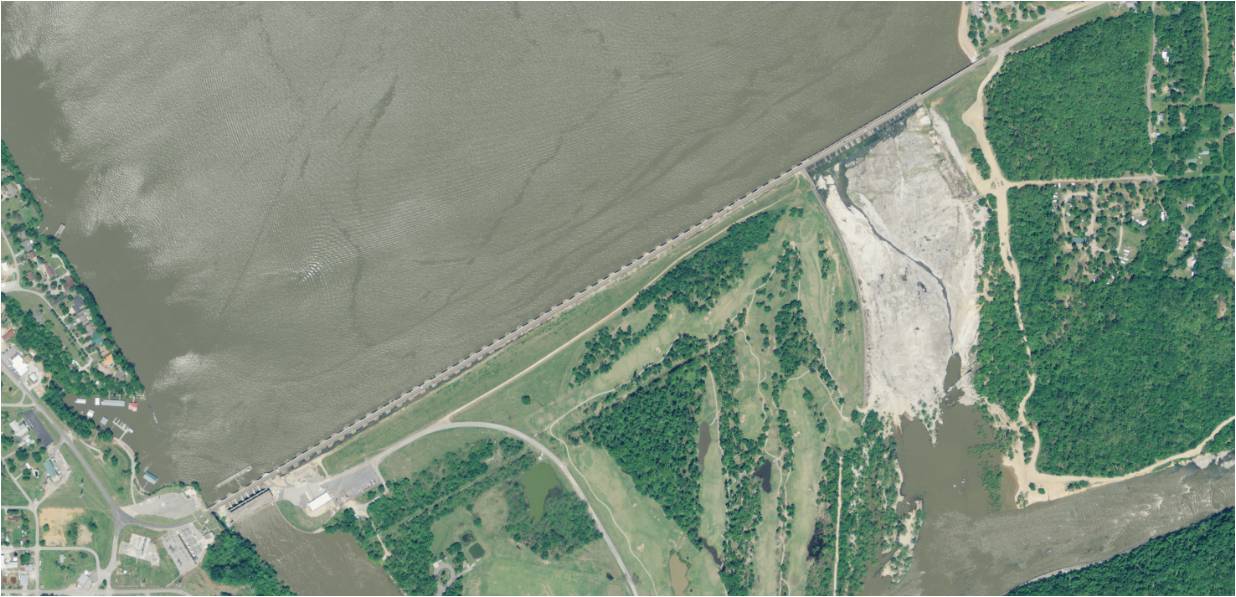
From the Air
Located at 36.472N, 95.033W between the towns of Disney and Langley in Mayes County, Oklahoma. The dam is dramatically visible from the air as a long curving structure spanning the Grand River, with Grand Lake o' the Cherokees extending to the northeast. The 51-arch structure and Highway 28 crossing the top are distinctive. Nearest airport is Grand Lake Regional Airport (3O9). Best viewed at 2,000-4,000 ft AGL. The lake's extensive shoreline and surrounding green hills are prominent landmarks.