Perth (Scotland)
You think you have reached the Highlands as the road climbs the ridge south of Perth, through bluffs and dark woods that look every bit the part. But it is a false summit -- just a spur of the Ochil Hills, with the true Highland Boundary Fault another ten miles north. This geographic tease is what has made Perth a gateway for centuries. Not quite Highland, not quite Lowland, the city sits at the exact point where the River Tay channels between hills, turns sharply east, and becomes tidal and navigable. Cattle drovers, traders, armies, and kings all converged here, following the Tay valley to the lowest point the river could be forded.
Saint John's Town
Medieval Scottish kings had no fixed capital, but their usual seat was at Scone, just north of Perth, where they were crowned on the Stone of Destiny. Perth itself was known as 'Saint John's Town,' a name that survives today in the local football club, St Johnstone. The city's association with royalty and power runs deep -- this was where parliaments met, where the great nobles of Scotland gathered, and where the conflicts of the realm often played out in real violence. The North Inch, the broad public park along the Tay, was the site of the extraordinary Battle of the Clans in 1396, when sixty Highland warriors fought to the death in a purpose-built arena before King Robert III. Walter Scott wove these royal intrigues into his novel The Fair Maid of Perth, and the place became known ever after as 'The Fair City.' Perth in Western Australia, Perth in Ontario, and Perth in Tasmania all took their names from this original.
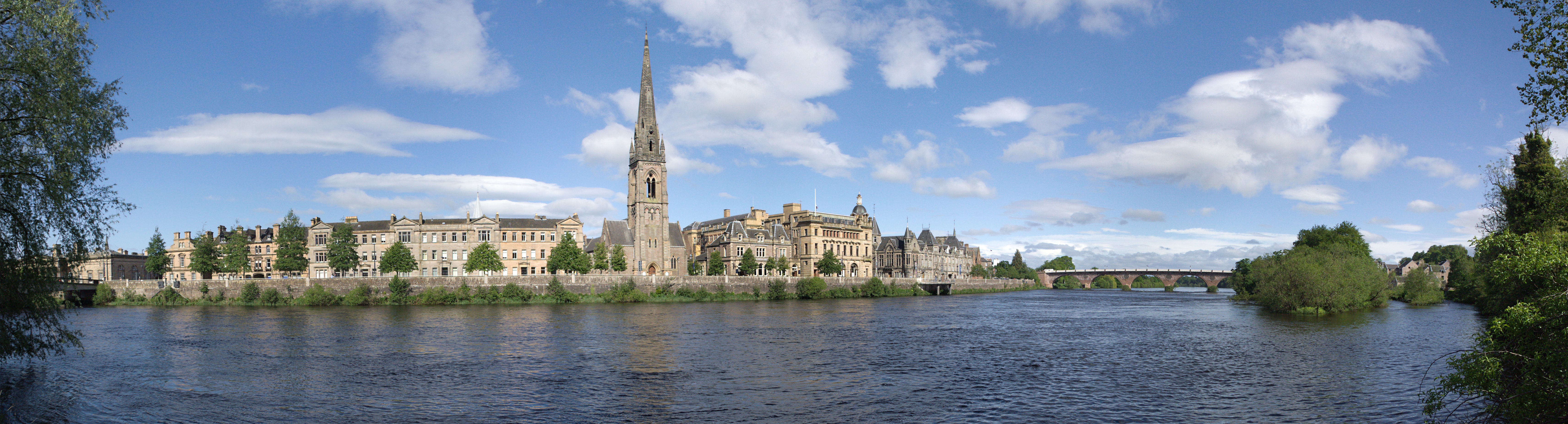
River and Ridge
Perth's geography is defined by two features: the Tay and the hills that flank it. Kinnoull Hill rises abruptly to 728 feet east of the city, its cliff edge topped by an eighteenth-century folly tower that looks as if it might topple into the river at any moment. Moncreiffe Hill, at 732 feet, forms the ridge to the south that tricks arriving motorists into thinking they have crossed into the Highlands. Between them, the Tay makes its sharp left turn, and the city fills the space between river and ridge. The North Inch and South Inch -- two large public parks -- give Perth an unusual amount of green space for a city its size. Scone Palace, the city's chief attraction, sits on the site of the ancient coronation ground just to the north, and the Stone of Destiny has returned to Perth, now displayed in Perth Museum after centuries of exile in London and Edinburgh.
Gateway Crossroads
Perth functions as a transport crossroads in a way few Scottish cities can match. The railway station, at the southwest edge of the city centre, connects to Edinburgh, Glasgow, Dundee, Aberdeen, and Inverness. The Caledonian Sleeper from London Euston reaches Perth before six in the morning -- early enough, as experienced travellers know, to be ejected onto a cold platform with no public transport yet running. The A9, Scotland's great north-south artery, bypasses the city to the west, linking Perth to Inverness via Pitlochry, Blair Atholl, and the bleak Drumochter Pass. Scone airfield, north of town, buzzes with private aviation and flight training but has no commercial flights. Stagecoach, the bus company, was founded and still maintains its headquarters in Perth -- an appropriate base for a firm whose business is getting people from one place to another, in a city whose entire history has been defined by the same function.
Fair City, Living City
Perth lost its official city status in the late twentieth century, though local signage stubbornly ignored this demotion until 2012, when the status was formally restored. The city today is a place of modest size -- about 47,000 people -- but outsized cultural weight. The Perth Highland Games are held at Scone Palace grounds each July. The European Pipe Band Championships bring the best pipe bands in the country to compete. The Farmers Market runs on the first Saturday of most months, filling High Street and King Edward Street with local produce. Lindores Abbey, just across the boundary into Fife, houses a whisky distillery on the site where medieval monks first produced aqua vitae. The hills begin properly at Birnam, a few miles north, where the road leads through Pitlochry and Blair Atholl into the true Highlands. To the east lies Dundee, reinvented and rejuvenated. To the southwest, the road runs via Gleneagles to Stirling. Perth sits at the centre of these spokes, as it always has -- not the destination, perhaps, but the place through which Scotland passes.
From the Air
Perth sits at approximately 56.40N, 3.43W where the River Tay makes a sharp eastward turn. The city is clearly identifiable from the air by the two large green parks (North and South Inch) flanking the river. Perth/Scone airfield (EGPT) is immediately north of the city. Best viewed at 2,000-3,000 ft AGL. Kinnoull Hill with its cliff-edge folly tower is a distinctive landmark east of the city. The Tay valley extending north toward Dunkeld provides clear navigational context.