Petit Jean State Park
According to legend, she cut her hair, dressed as a boy, and talked her way aboard as a cabin boy. The young 18th-century French woman had discovered that her fiance planned to explore the Louisiana Territory, and she was not about to be left behind. She survived the Atlantic crossing and joined the expedition into the interior. When they reached a flat-topped mountain above the Arkansas River, she fell gravely ill. On her deathbed, she revealed her identity to her stunned fiance. They buried her on the mountain -- not under her real name, which history has lost, but under the name the crew had known her by: Petit Jean, "Little John." Locals pronounce it PET-ih jeen. Her grave overlooking the Arkansas River Valley is still there, and the mountain, the park, and the legend all bear her name.
Stone, Timber, and the CCC
Petit Jean State Park sits atop Petit Jean Mountain in Conway County, wedged between the Ouachita Mountains and the Ozark Plateaus, overlooking the Arkansas River. It was established in 1923 as Arkansas's first state park, but the park visitors see today was largely built in the 1930s by the Civilian Conservation Corps. CCC crews constructed roads, buildings, trails, and the dams that impound Lake Bailey and Roosevelt Lake. Their work defines the park's character: log-and-stone structures in the Rustic style scattered through the forest, including four original cabins built around 1935. Cabin number 6 has a shed-roof porch with views into the canyon. Cabin number 9 still has its original stone masonry cooking pit nearby. The main administration building, also from 1935, now serves partly as a gift shop. Even the park's original water treatment building, a square stone structure tucked away from tourist facilities, was built in the Rustic style. Many of these structures are listed on the National Register of Historic Places.
Cedar Falls and the Canyon
Cedar Creek carved the deep forested canyon that gives Petit Jean its dramatic setting. The creek cascades over a ledge into the canyon in an impressive waterfall known as Cedar Falls. Above the falls, Cedar Creek has been dammed to create Lake Bailey, a calm body of water used for pedal-boating and fishing. The CCC-built Cedar Falls Trail descends from Mather Lodge into the canyon, crossing Cedar Creek on a handsome stone bridge. Mather Lodge itself, a 24-room historic lodge, perches on the edge of a bluff overlooking the canyon -- one of the most photographed settings in the Arkansas state park system. In addition to the lodge, the park offers 32 cabins and 127 campsites. In 2017, Petit Jean was rated the best campsite in Arkansas in a 50-state survey.
Rock Houses, Turtle Rocks, and a Museum of Automobiles
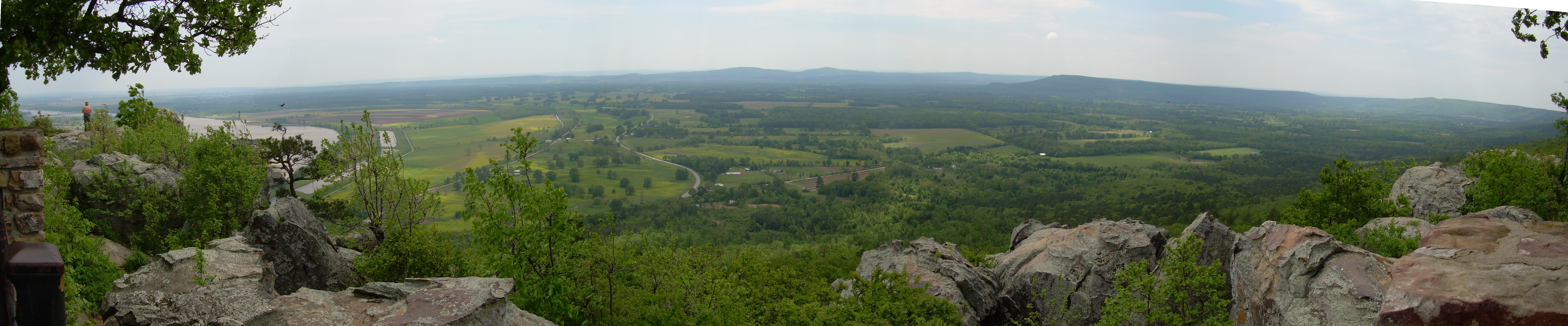
The mountain's geology provides as much to explore as its human history. Bear Cave, Rock House Cave, the Grotto, Turtle Rocks, Carpet Rocks, and Natural Bridge are scattered across the park, each a product of the sandstone and shale formations that make up Petit Jean Mountain. Rock House Cave contains archaeological evidence of ancient human habitation -- the mountain has attracted people for far longer than the legend of the French cabin boy suggests. The scenic overlook at Petit Jean's grave provides a panoramic view of the Arkansas River Valley, with the river itself visible winding through the lowlands far below. Less than a mile from the main camping areas sits the Museum of Automobiles, an unexpected attraction that houses a collection of vintage cars on the mountaintop. The park also contains a now-disused pedestrian bridge built of concrete sculpted to resemble logs, a cruder cousin of the faux-bois work of artist Dionicio Rodriguez found elsewhere in Arkansas.
Roads Built to Last
The CCC's engineering at Petit Jean went well beyond cabin construction. The Blue Hole Road, which now forms part of the Boy Scout Trail, originally provided vehicular access from the Red Bluff loop road down to the Blue Hole swimming area. Its surviving culverts, retaining walls, and guard rails testify to the care these Depression-era crews brought to their work. Two CCC-built road structures remain in active vehicular use: a stone box culvert underlying Highway 154, the park's main access road, and the Cedar Creek Bridge, which carries Red Bluff Drive over Cedar Creek just below the outlet of Lake Roosevelt. These structures have carried traffic for nearly a century without replacement. The park sits in a transitional zone between the Ouachita Mountains to the south and the Ozark Plateaus to the north, a geological meeting point that gives the mountain its unusual flat-topped profile. From the overlook, on a clear day, the view stretches across the river valley to the horizon -- the same vista that the young woman called Little John supposedly saw in her final days, a landscape that has been drawing people to this mountain ever since.
From the Air
Located at 35.12°N, 92.94°W in Conway County, Arkansas, between the Ouachita Mountains and Ozark Plateaus. Morrilton Municipal Airport (KBDQ) is approximately 10 nm northeast. Little Rock's Clinton National Airport (KLIT) is about 55 nm southeast. Petit Jean Mountain is a distinctive flat-topped mesa visible from altitude, rising above the Arkansas River Valley. The Arkansas River runs along the mountain's south side and is a strong visual reference. Cedar Falls canyon cuts into the mountain's interior. Mather Lodge is visible on the bluff edge. Lake Bailey and Lake Roosevelt are small impoundments on the mountain. The Museum of Automobiles complex is visible near the camping areas. Approach with awareness of mountain terrain and possible turbulence over ridges. Best viewing at 3,000-4,000 feet AGL.