Phong Nha Cave
The name translates as "Wind and Teeth" -- a reference to the jagged stalagmites that once flanked the cave's entrance like the jaws of something ancient and patient. Phong Nha Cave sits inside the Phong Nha-Ke Bang National Park in Vietnam's Quang Binh Province, a UNESCO World Heritage Site that shelters one of the oldest and most extensive karst landscapes in Asia. The cave itself stretches 7,729 meters into the earth, but what makes it extraordinary is what moves through it: the Son River, which runs nearly 14 kilometers underground before emerging from the cave mouth into daylight, draining a vast network of limestone mountains that have been dissolving and rebuilding themselves for over 400 million years.
A River Through Stone
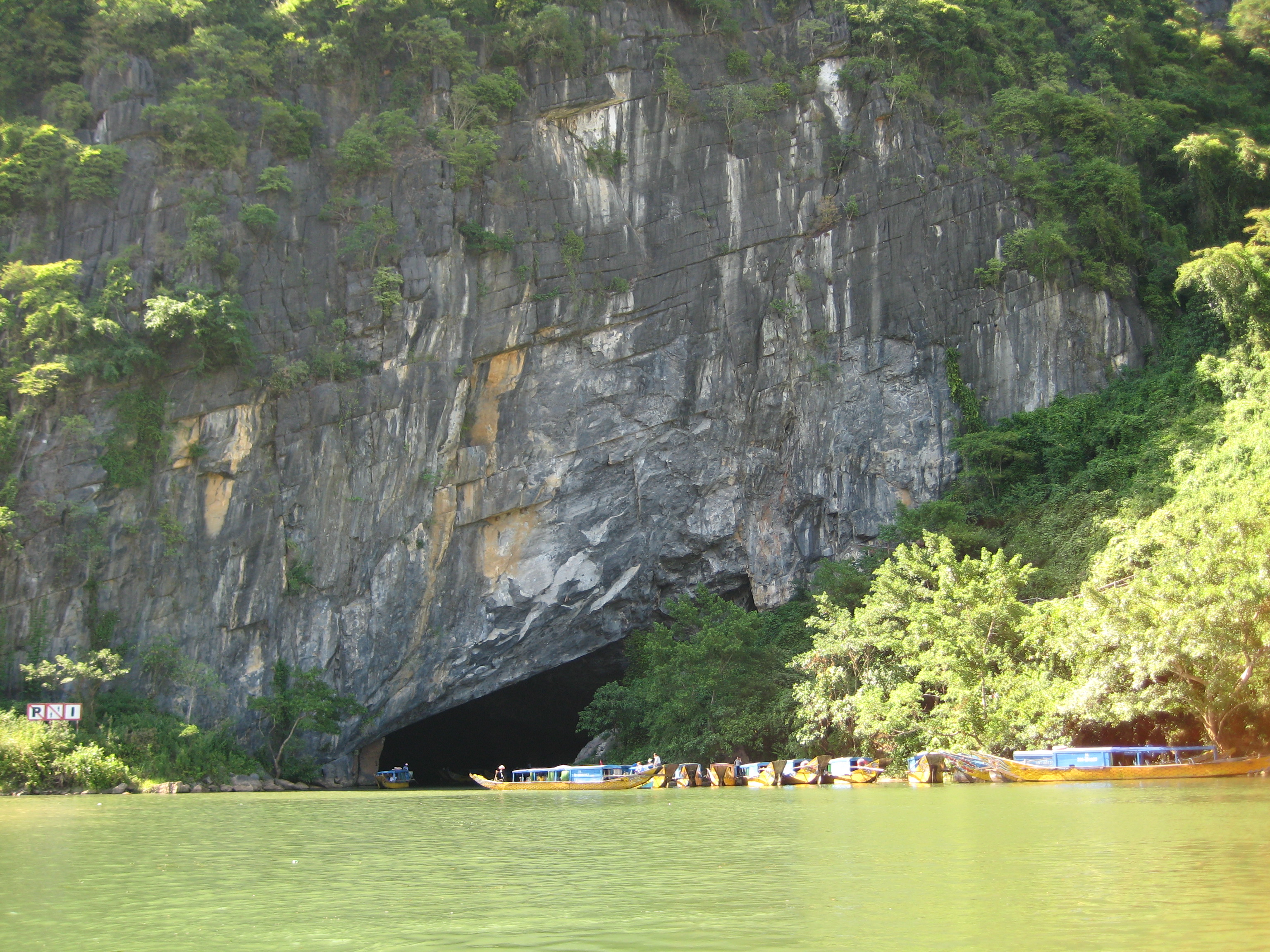
To enter Phong Nha is to travel by boat into the mountain. The Son River carries visitors through the cave's gaping entrance and into a darkness punctuated by the slow drip of mineral-laden water. The cave contains 14 grottoes, each with its own character -- some vaulted like cathedrals, others narrow and intimate. Scientists have surveyed 44.5 kilometers of passages threading through the surrounding karst, but tourists penetrate only the first 1,500 meters, a fraction of the system's true scale. Beyond the lit pathways, the cave extends into unmapped corridors where the river's echo is the only sound. The British Cave Research Association has recognized the system for its geographic features: the underground river, a large subterranean lake, and entrance dimensions that dwarf most caves on the continent.
Sculpted by Imagination
The formations inside Phong Nha have been accumulating for millennia, and the human instinct to see shapes in stone has given them names. The "Lion" crouches in one grotto; the "Unicorn" and "Kneeling Elephant" guard another. A formation called "the Buddha" sits in serene stillness, its contours shaped by water so patient it makes geologic time feel personal. The Bi Ky grottoes hold some of the most intricate stalactite and stalagmite formations in the system -- curtains of mineral deposits that hang from ceilings like frozen waterfalls, and columns that have been growing upward from the cave floor grain by grain since before any human civilization existed. Sandbanks and reefs line the underground river's course, remnants of ancient seas that once covered this part of Southeast Asia.
Neighbor to Giants
Phong Nha is famous in its own right, but it exists in remarkable company. The surrounding national park contains Hang Son Doong, the largest cave passage in the world by volume, discovered in 1990 by a local farmer and not fully explored until 2009. Hang En, another massive cave nearby, serves as a natural campsite for adventurers trekking through the jungle. The entire Phong Nha-Ke Bang karst system represents one of the most significant examples of continental karst formation on Earth, with geological evidence stretching back to the Paleozoic era. The park's dense tropical forest conceals dozens of caves that remain only partially explored, their entrances hidden beneath the canopy. For the caves that have been mapped, the numbers are staggering -- hundreds of kilometers of passages, some reaching depths that challenge the limits of exploration technology.
Between War and Wonder
Quang Binh Province, where the cave sits, occupies a narrow strip of Vietnam squeezed between the Annamite Mountains and the South China Sea. During the American War, this region endured some of the heaviest bombing in history, as the Ho Chi Minh Trail wound through its mountains and valleys. The caves themselves served as shelters and staging areas. Phong Nha's grottoes provided refuge for local populations and soldiers during the conflict, their massive chambers offering protection that no man-made structure could match. Today the province has transformed itself around its geological inheritance. The town of Phong Nha has grown from a quiet farming settlement into a hub for adventure tourism, its guesthouses and restaurants serving travelers who come to explore a landscape that spent most of the twentieth century off-limits to outsiders.
Into the Dark
The climate inside Phong Nha stays cool year-round, a constant counterpoint to the tropical heat outside. Heavy rains can swell the Son River and limit access, making the dry season from February to August the preferred window for visitors. From the air, the cave system is invisible -- what you see instead is an unbroken expanse of jungle-covered karst peaks, their limestone flanks eroded into sharp ridges and deep sinkholes. The cave entrance appears as a dark opening at the base of a cliff where the river emerges, unremarkable from altitude but concealing a world underneath that dwarfs anything visible on the surface. It is a landscape that rewards patience and proximity, revealing itself only to those willing to leave the sunlight behind.
From the Air
Located at 17.58°N, 106.28°E in Quang Binh Province, central Vietnam. The cave entrance sits at the base of karst cliffs along the Son River, visible as a dark opening in dense jungle terrain. Nearest airport is Dong Hoi Airport (VVDH), approximately 50 km to the southeast. The surrounding Phong Nha-Ke Bang National Park covers rugged karst mountains best viewed at 3,000-5,000 feet AGL. The narrow coastal plain between the Annamite Range and the South China Sea makes this corridor visually distinctive from cruising altitude.