Pictured Rocks
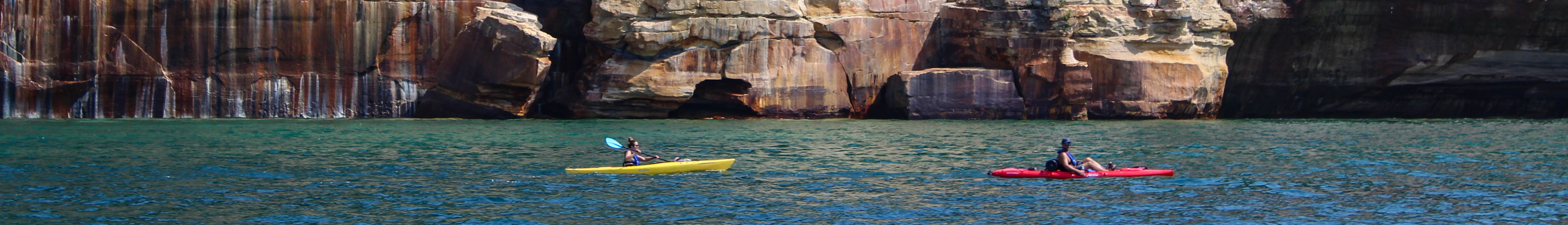
Pictured Rocks earned its name from the mineral stains that streak its sandstone cliffs - iron oxide for red, copper for green and blue, manganese for black, limonite for yellow. The result is 200-foot walls of stone that look like abstract paintings rising directly from Lake Superior's clear blue water. Henry Schoolcraft, the explorer who 'discovered' the source of the Mississippi, visited in 1820 and called the cliffs 'the most impressive natural wonder he had ever seen.' In 1966, Pictured Rocks became America's first national lakeshore - a new type of designation recognizing that some shorelines deserved the same protection as parks. The 42-mile shoreline includes not just the painted cliffs but sand dunes, waterfalls, beaches, and forests. Superior's cold, clear water - visible 40 feet deep - and the North Country's isolation create one of the most spectacular stretches of coast in America.
The Geology
The Pictured Rocks cliffs are Cambrian sandstone, laid down 500 million years ago when Michigan was under a shallow sea. Subsequent burial, compression, and uplift created layered sedimentary rock. Lake Superior carved the cliffs as water levels changed over millennia. The colors come from groundwater carrying dissolved minerals through the porous rock - iron compounds create reds and oranges, copper makes greens and blues, manganese leaves black streaks. The staining is ongoing; the cliffs are still being painted. The rock formations have names: Miners Castle, Battleship Row, Lovers Leap. Caves and arches punctuate the cliff face.
The Lake
Lake Superior is the largest freshwater lake by surface area in the world, and it defines the Pictured Rocks experience. Superior's cold, clear water allows visibility of 40 feet or more - you can see the rocks beneath the surface as you paddle past the cliffs. The lake moderates temperatures but also creates weather: fog, sudden storms, and waves that have sunk hundreds of ships. Superior is too cold for most swimming (averaging 40°F); kayakers wear wetsuits. The lake's power is evident in the wave-carved caves and arches along the cliffs.
The Waterfalls
Pictured Rocks includes numerous waterfalls where streams plunge over sandstone ledges. Munising Falls drops 50 feet in the town of Munising. Miners Falls is a 40-foot cascade accessible by short trail. Spray Falls pours directly into Lake Superior - best seen from the water. Chapel Falls drops 60 feet through a forested gorge. The falls are most impressive in spring, when snowmelt swells the streams; by late summer, some are reduced to trickles. The same geology that created the painted cliffs - layered sandstone resistant to erosion - creates the waterfalls where streams cross resistant layers.
The Access
The painted cliffs are best seen from the water. Kayaking is the premier experience - paddling beneath 200-foot walls, exploring sea caves, and seeing the colors close up. Guided kayak tours operate from Munising. Boat tours run from May through October for those who prefer to stay dry. The North Country Trail follows the clifftop for hikers, offering overlook views. Miners Castle is the most accessible cliff viewpoint from land. Backcountry camping is available at designated sites along the lakeshore. The Upper Peninsula's isolation limits crowds; this is wilderness, not Yellowstone.
Visiting Pictured Rocks
Pictured Rocks National Lakeshore extends along 42 miles of Lake Superior shore in Michigan's Upper Peninsula, centered on the town of Munising. The Munising Falls Visitor Center provides orientation. Boat tours of the painted cliffs run from Munising; book ahead in summer. Kayak rentals and guided trips are widely available - Superior demands respect; guided tours are recommended for novices. Miners Castle is the most accessible viewpoint. The North Country Trail offers backpacking; permits required for backcountry camping. The UP is remote; Marquette is the nearest city with significant services. Sawyer International Airport (MQT) in Marquette has limited service. Summer is peak season; fall colors are spectacular; winter brings ice formations.
From the Air
Located at 46.56°N, 86.33°W along the Lake Superior shore in Michigan's Upper Peninsula. From altitude, the Pictured Rocks cliffs are visible as a continuous wall of sandstone along the blue expanse of Lake Superior. The mineral staining is evident as color variations on the cliff face. Grand Island sits offshore near Munising. The interior is forested and largely undeveloped. The UP's isolation - separated from the rest of Michigan by the Straits of Mackinac - is evident in the sparse development.