Pillars of Hercules
For the ancient world, this was where the map ended. Two mountains guarding a narrow strait, beyond which lay nothing but open ocean and the unknown. The Greeks called them the Pillars of Hercules, and the warning they carried was explicit: Ne plus ultra -- nothing further beyond. Plato placed Atlantis past these pillars. Dante sent Ulysses through them to his doom. Phoenician merchants, braver or greedier than mythology allowed, sailed past them anyway, building colonies down the African coast. The Pillars of Hercules are where geography became legend, and where legend became a border that shaped European civilization for two thousand years.
The Tenth Labor
According to Greek mythology, Hercules created the strait during his tenth labor, when he was tasked with fetching the cattle of Geryon from the far west. Approaching the mountain that was once Atlas, Hercules chose not to climb but to smash through, connecting the Atlantic Ocean to the Mediterranean and forming the Strait of Gibraltar. One half of the split mountain became Gibraltar; the other became either Monte Hacho in Ceuta or Jebel Musa in Morocco -- the identity of the southern pillar has been disputed since antiquity. Diodorus Siculus offered an alternative version: rather than splitting the mountain apart, Hercules narrowed an already existing strait to prevent monsters from the Atlantic from entering the Mediterranean. In yet another telling, he built the two pillars to hold the sky away from the earth, liberating Atlas from his eternal burden.
Phoenician Ambition, Greek Caution
The Phoenicians were the first to treat the Pillars as a gateway rather than a boundary. Their merchant fleets pushed through the strait and began building colonies along the Atlantic coast of Morocco -- Lixus in the north, then Chellah, and finally Mogador to the south. Near the island of Gades, modern Cadiz, Strabo described a temple to Tyrian Heracles containing two bronze pillars eight cubits high, which many visitors proclaimed to be the true Pillars of Hercules. Strabo was skeptical: the inscriptions on those pillars, he noted, said nothing about Heracles and spoke only of the expenses the Phoenicians had incurred in making them. The Greeks were more cautious about what lay beyond. Pindar called the Pillars the "gates of Gades" and declared them the farthest limits reached by Heracles -- a boundary even a demigod respected.
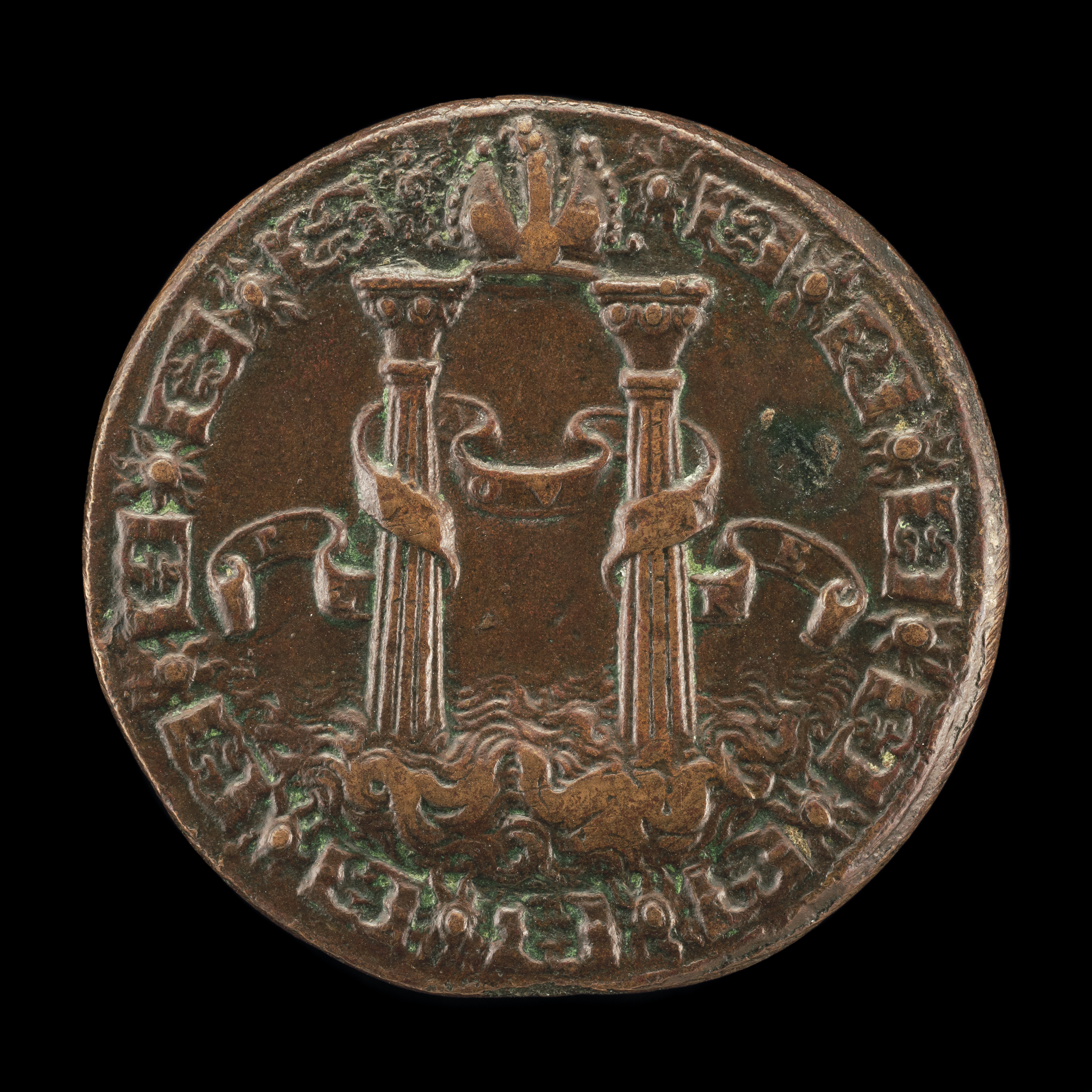
From Warning to Invitation
The Pillars' meaning inverted after 1492. When Columbus crossed the Atlantic and returned, Spain's King Charles I adopted the Pillars as his personal emblem but replaced the ancient warning Ne plus ultra with a new motto: Plus Ultra -- further beyond. The Pillars now appeared as supporters on the coat of arms of Spain, framing the shield as gateways to empire rather than barriers against the unknown. The Italian humanist Luigi Marliano conceived the design. Today the Pillars appear on the coats of arms of Andalusia, Extremadura, Melilla, Cadiz, and even the Mexican states of Veracruz and Tabasco -- remnants of Spain's global reach radiating outward from the strait where Hercules once stood. The dollar sign itself may derive from the scrollwork wrapping around the Pillars on Spanish colonial coins.
Standing at the Edge
The geography that inspired the myth remains strikingly dramatic. The Strait of Gibraltar is only 14 kilometers wide at its narrowest point, and on a clear day the African and European coasts are plainly visible to each other. The Rock of Gibraltar, the northern pillar, rises 426 meters from the sea, a sheer limestone mass that has been fought over by every naval power in western history. Across the water, Jebel Musa rises to 851 meters on the Moroccan shore, while Monte Hacho in Ceuta offers its own claim as the southern pillar. From the air, the strait appears as a narrow channel where two continents nearly touch -- the point where the Mediterranean empties into the Atlantic, where Europe reaches toward Africa, and where an ancient myth about the limits of human ambition remains carved into the landscape.
From the Air
Coordinates: 36.00N, 5.35W. The Pillars of Hercules flank the Strait of Gibraltar, which is 14 km wide at its narrowest. The Rock of Gibraltar (426 m) is the northern pillar; Jebel Musa (851 m) in Morocco or Monte Hacho in Ceuta is the southern. From any altitude, the strait is a dramatic narrowing between continents. Gibraltar Airport (LXGB) sits on a narrow isthmus at the Rock's base. Tangier Ibn Battouta Airport (GMTT) serves the Moroccan side. The strait's currents and winds are visible in sea surface patterns.