Pitcairn Islands
Getting to Pitcairn requires a flight to Tahiti, a connecting flight to Mangareva in the Gambier Islands, and then thirty-two hours aboard the Silver Supporter as it crosses 530 kilometers of open Pacific. There is no airport. There are no regular schedules. The island's population - roughly forty souls, most descended from nine mutineers and their Tahitian companions - can only sustain visitors in small numbers. This is the last British territory in the South Pacific, the most isolated inhabited island on Earth, a place where the internal economy still runs on barter and the electricity comes on for five hours in the morning, five in the evening. If you're looking for accessibility, look elsewhere. If you're looking for the edge of the world, you've found it.
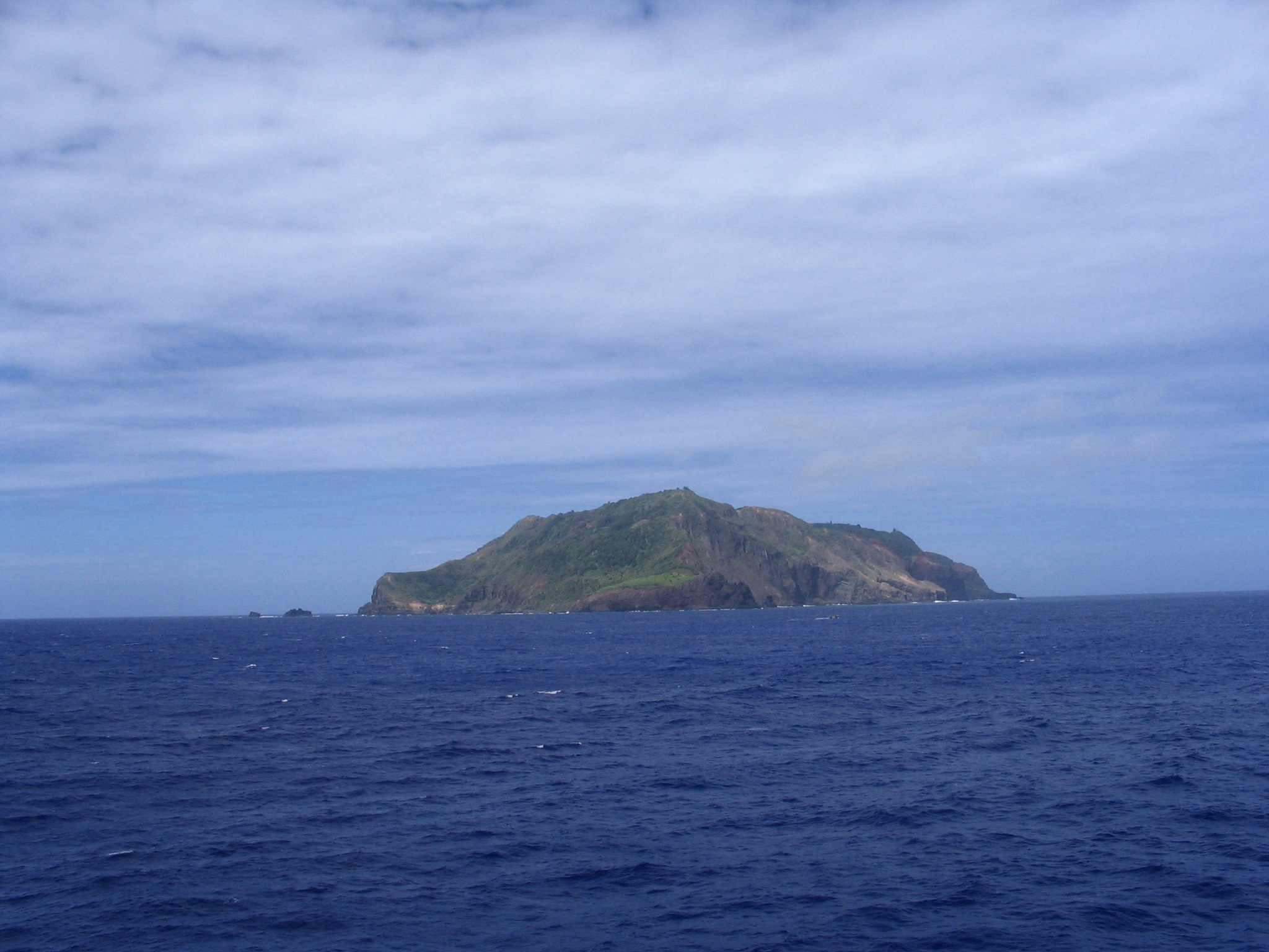
The Hill of Difficulty
Pitcairn juts from the Pacific like a volcanic fist - 337 meters of steep rock with no harbor, no beach worthy of the name, and only one place to land a boat. Bounty Bay is less a bay than a notch in the cliff face, where swells funnel between rocks and small boats must time their approach between waves. From here, the only road climbs what the locals call the Hill of Difficulty, a name earned by generations of settlers hauling supplies from ship to settlement.
Adamstown sprawls across the island's one relatively flat area - forty-odd houses, a church, a post office, a museum containing Fletcher Christian's Bible and the Bounty's anchor. The paths between them are dirt tracks suitable for walking or all-terrain vehicles. The concept of 'traffic' doesn't apply. If you need to get somewhere and don't have transport, you wait until someone passes who does.
The Hardest Place to Visit
The Silver Supporter makes roughly twenty-six round trips per year between Pitcairn and Mangareva. The fare is NZ$6,000. Your stay aligns with the ship's schedule - typically a few days to a couple of weeks, depending on the voyage pattern. There are no same-day options, no alternatives if plans change. If you miss your departure, you're staying until the next one.
Visitors under fourteen days need no visa but must still coordinate through the tourism office. Longer stays require permission from the Governor, a NZ$300 fee, and proof of accommodation - because irregular transport means you're effectively becoming a temporary resident. The island's limited resources can't absorb unexpected arrivals. Even the general store opens only three mornings a week, for an hour at a time, selling goods ordered in advance by customers.
Island Life
The population hovers around forty - down from a peak of 233 in 1937. Emigration has drained the island steadily: first to Norfolk Island, then to New Zealand, as young people sought opportunities that a two-square-mile rock in the Pacific cannot provide. The remaining residents maintain the only lifestyle possible here: fishing, farming, crafting souvenirs for the occasional visitor.
Locally made goods include woven baskets, honey from the island's disease-free bees, and carvings of wildlife made from miro wood harvested on Henderson Island. The postage stamps are collector's items, available by mail worldwide. Most families keep goats and chickens. Fish is plentiful - nanwi, red snapper, tuna - pulled fresh from waters that haven't been commercially fished.
The Seventh Day Adventist Church shapes social life, a legacy of 19th-century missionaries. Saturday is the Sabbath. Dancing and public affection are discouraged. Alcohol was prohibited until 1991. Christian's Cafe opens on Fridays.
The Other Islands
Henderson Island is the largest of the group - a raised coral atoll thirty kilometers across, UNESCO World Heritage listed for its endemic species. Four birds found nowhere else on Earth nest here: the Henderson crake, Henderson fruit dove, Henderson lorikeet, and Henderson warbler. The island is uninhabited, difficult to land on, and strictly protected. Its caves hold evidence of Polynesian visitors who came before the mutineers, tried to settle, and failed.
Oeno and Sandy Island offer the closest thing to beach paradise - coral atolls with lagoons, palm trees, and the white sand that Pitcairn lacks. Locals make occasional trips to swim and picnic. Ducie Atoll lies 480 kilometers distant, beyond the range of the islanders' boats, visited only by rare research expeditions and wandering seabirds. Together, the four islands form Britain's smallest overseas territory by population and among its largest by exclusive economic zone.
The Price of Isolation
Pitcairn's medical clinic has basic equipment and a New Zealand doctor, but the island lies beyond helicopter range of everywhere. A serious injury or illness means waiting for a passing ship or arranging an emergency evacuation that could cost hundreds of thousands of dollars. Visitors over forty are advised to get EKG and ultrasound screenings before coming - precautions not generally covered by insurance but essential when the nearest hospital is weeks away.
The 2004 sexual abuse trials cast a long shadow. Multiple convictions, including the former mayor, rocked a community where everyone is related to everyone. The island's self-sufficiency, already tenuous, was further strained. Young people continued to leave. Whether Pitcairn society survives another generation remains genuinely uncertain.
Yet visitors still come - for the history, for the remoteness, for the experience of existing briefly at the absolute limit of connectivity. No broadcast television or radio reaches here. Mobile coverage arrived only in 2017, a 4G network shared among forty people. The rest of the world feels very far away. That's the point.
From the Air
Located at 25.07S, 130.11W. Pitcairn Island is volcanic, rising steeply to 337m with no flat land suitable for a runway. There is no airport anywhere in the territory. The island is roughly 3.2km long and 1.6km wide. Bounty Bay on the north coast is the only landing point - look for the single road climbing inland from the coast (the Hill of Difficulty). Adamstown, the sole settlement, sits on a plateau in the island's center. Henderson Island lies 200km northeast - a flat coral platform visible from altitude. Nearest airports: Totegegie (GMR) on Mangareva, 530km northwest, or Mataveri (IPC) on Easter Island, 2,000km east. The islands sit in the South Pacific trade wind belt; weather is tropical maritime with typhoon risk November-March. Flight over this area requires careful long-range planning - there are no emergency landing options within hundreds of kilometers.