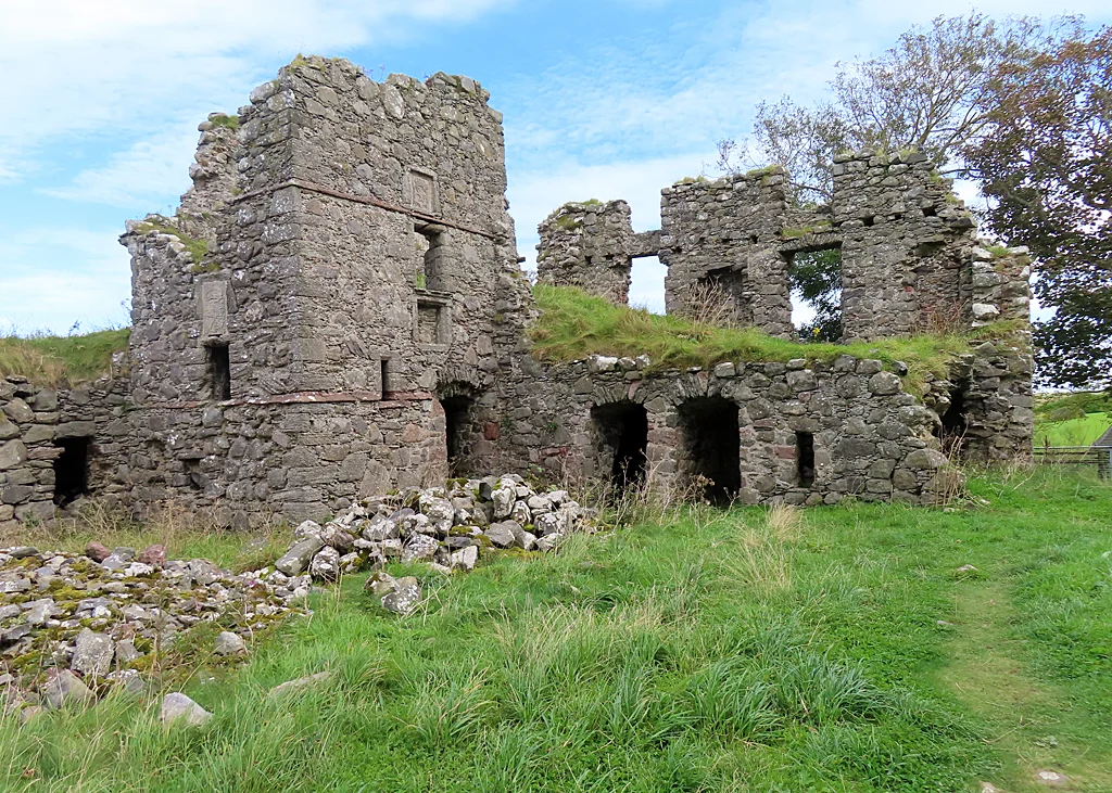

Pitsligo Castle
The walls of the drum tower at Pitsligo Castle are nine feet thick. They were built that way in the early fifteenth century, when stone was the only effective answer to anyone who came calling with bad intentions. The keep dates to 1424. Six centuries later, what stands above ground is roofless but stubborn - an outer court, an inner court, gateways carved with arms and dates, and that tower at the north-east angle, still squared against the Aberdeenshire wind. The castle sits half a mile east of Rosehearty, on the coast where the road from Fraserburgh curves west. Most travellers drive past without slowing. The ones who stop are usually the ones who already knew it was there.
Six Hundred Years of Stone
Pitsligo began as a keep in 1424 - one tower, square or rectangular, built for a noble family in a country where a noble family without defences was a noble family with a short future. Over the next two centuries the keep became a castle and the castle became a courtyard residence. The arched gateway in the west wall of the outer court carries the date 1656 and the carved arms of the Forbes and Erskine families, who were modifying and rebuilding it in the seventeenth century. The inner court gate carries 1663. The drum tower at the north-east angle - the one with the nine-foot walls - was built by the Frasers of Philorth, the same family that founded Fraserburgh up the coast. The history is layered in stone the way many Scottish castles are: each generation adding, each rebuilding, until the whole reads like geological strata.
The Forbes Modifications
It was the Forbes of Druminnor who gave Pitsligo most of its visible character. They modified the castle in the 1570s, building out from the original keep into a courtyard plan with substantial domestic buildings. Their carved arms above the gateway, paired with the Erskines, mark the marriages and alliances that made the modifications possible. Across the centuries the Forbes family held Pitsligo through political weather as changeable as Aberdeenshire's actual weather. By the time the architectural historian Charles McKean visited around 1990, the castle was a ruin - but a ruin in good condition. A fine walled garden lay to the north and a walled enclosure to the west, the bones of a substantial residential complex still legible in the surviving fabric.
Saved by a Publisher
The story of Pitsligo's modern preservation has an unexpected protagonist. Around the same time as McKean's visit, the castle was consolidated by Douglas Forrest, a firm of Scottish architects, for Malcolm Forbes - the American publisher of Forbes magazine. Forbes, who claimed Scottish ancestry, had acquired the castle and put resources into making sure it would survive another century. He died in 1990, the year his consolidation work was being done. The arrangement is one of those quiet, slightly improbable links between American wealth and Scottish ruins that have kept many old castles upright. Today Pitsligo is listed by Historic Environment Scotland as a scheduled monument - the highest level of legal protection, recognising it as a site of national importance.
What Remains
Pitsligo is open to anyone who walks up to it. There are no ticket booths, no opening hours, no audio guides. The castle sits in a field above the coast, its walls weathered to the colour of bone, and a small virtual tour exists online for those who want to see what they would otherwise miss. The drum tower at the north-east corner still squares the courtyard the way it has since the Frasers built it. The Forbes arms still ride above the western gate. The dates on the stonework still read 1656 and 1663, marking generations who would have known the castle as their home. For everyone else, it is now what most Scottish castles eventually become: a reminder that what survives this long usually survives because someone, somewhere, decided it should.
From the Air
Coordinates 57.6923N, 2.1069W. Pitsligo Castle is half a mile east of Rosehearty on the Aberdeenshire coast, about 5 nm west of Fraserburgh. From altitude the ruin reads as a small rectangular complex set back from the shore in farmland. Best viewing altitude is 1,500-3,000 ft. Nearest airport is Aberdeen (EGPD) about 35 nm south-southwest; Lossiemouth (EGQS) is 50 nm west. Coastal weather is typical of the Buchan headland - persistent wind, variable cloud, often hazy visibility over the sea. The Moray Firth opens to the west.
Nearby Stories
- Tarlair Swimming Pool 8.2 km away
- New Slains Castle 9.4 km away
- Battle of Slioch 17 km away
- German submarine U-58 (1938) 32 km away
- HMS Exmouth (H02) 33 km away
- Piper Alpha 109 km away
- German submarine U-1274 209 km away
- Jarlshof 236 km away