Poas Volcano National Park
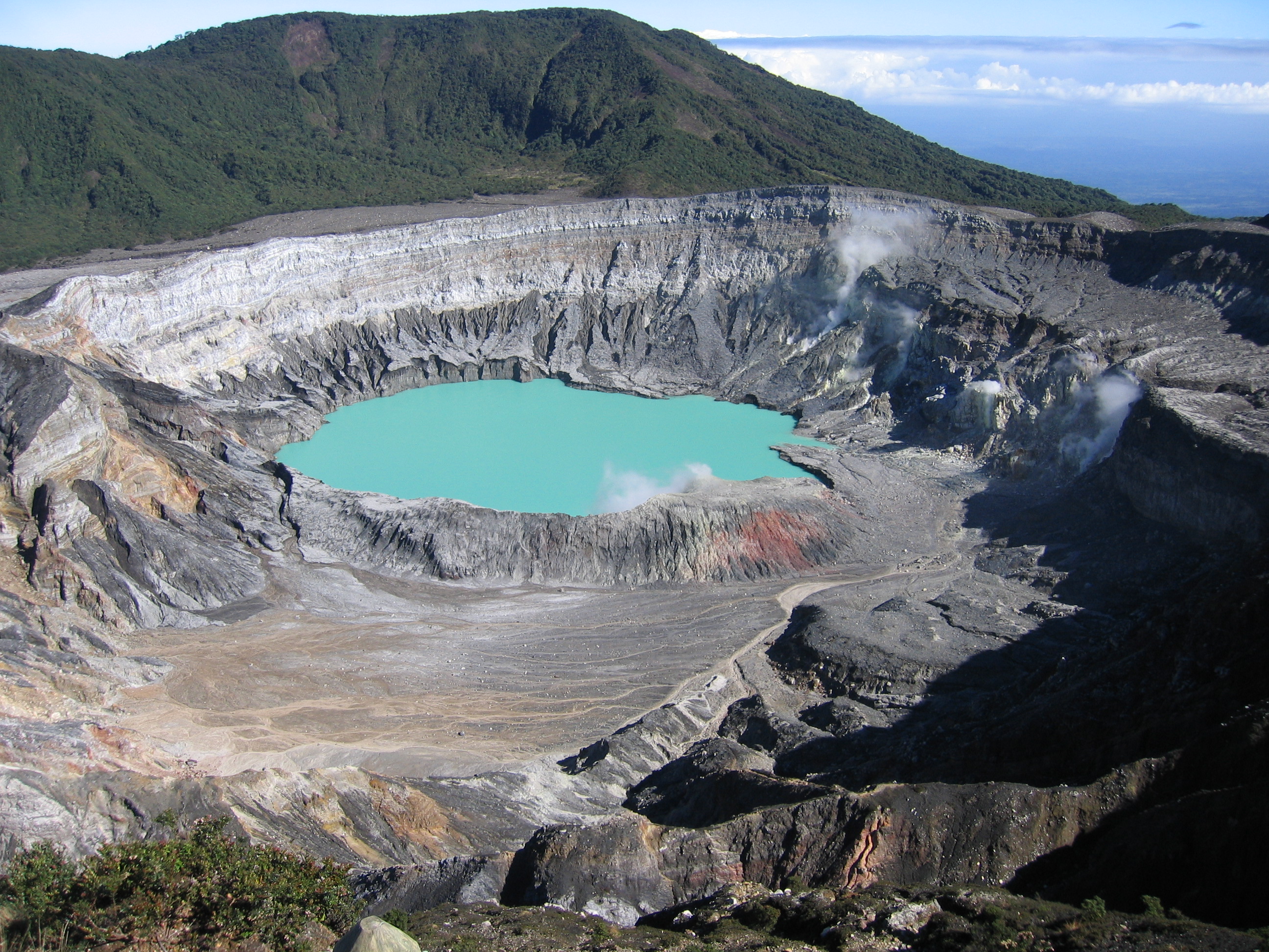
The smell hits before the view does. Sulfur, acrid and unmistakable, drifts up from a crater so wide you could lay a dozen city blocks inside it. Poas Volcano sits at 2,708 meters in Costa Rica's Central Valley, its main crater stretching 1.32 kilometers across and plunging 300 meters deep - dimensions that make it the largest geyser-type crater in the world. At the bottom, an acid lagoon simmers in shifting shades of turquoise and gray, its surface broken by gas emissions that have been documented since at least 1747, when Spanish governor Juan Gemir first reported the volcano's restless behavior. This is the most visited national park in Costa Rica, and the reason is simple: nowhere else can you stand at the rim of an active volcano and peer straight into its throat.
A Crater That Breathes
Poas is a stratovolcano, built layer by layer from eruptions spanning millennia. Its summit holds not one spectacle but three: the main crater with its acid lake, the dormant Botos crater cradling a cold-water lagoon ringed by cloud forest, and the Von Frantzius cone, a remnant of older activity. The main crater remains the draw. Small gas emissions rise continually from its floor, the acid lagoon shifting color with the chemistry beneath. In 1910, the volcano produced an ash cloud that climbed to approximately 8,000 meters - its most dramatic recorded outburst. The last major eruptive period, between 1952 and 1954, sent incandescent rocks skyward accompanied by subterranean rumblings that rattled surrounding villages. The volcano has quieted since, though the hissing vents and sulfurous air leave no doubt that the engine below is merely idling.
Two Worlds at the Summit
Walk the trail from the main crater to Lake Botos and you cross between geological eras. The main crater is raw geology - exposed rock, mineral stains, the sharp bite of sulfur. Botos, by contrast, sits in a dormant crater that nature has softened with centuries of growth. Cloud forest crowds its rim, epiphytic plants draping the tree trunks in moss, ferns, bromeliads, and orchids. Scrub forest and myrtle forest occupy the transitional zones, each habitat hosting its own community of species. The contrast is striking: destruction and creation separated by a twenty-minute hike. The park protects several distinct habitat types across its elevation range, from sparse volcanic terrain where almost nothing grows to dense canopy so thick that sunlight barely reaches the forest floor.
The Road Up the Mountain
Getting to Poas is half the experience. The park lies 45 kilometers northwest of San Jose, and the road that climbs to the summit winds through a landscape that changes with every hairpin turn. Coffee plantations give way to pastures, then to sections of forest broken by small streams and waterfalls. The towns along the route - Fraijanes, Poas, Varablanca - are picturesque stops where roadside vendors sell strawberries, cheese, custard, and flowers grown in the cool mountain air. Most of these small businesses belong to local families, and they've built a livelihood from the steady stream of visitors heading uphill. The Varablanca route connects the volcano region to Puerto Viejo de Sarapiqui on the Caribbean side, threading through some of the most scenic terrain in the Central Valley.
Spiky Plants and a Borrowed Name
Nobody is entirely sure where the name Poas comes from. One theory traces it to the Latin word puas, meaning thorns or spikes, a reference to the sharp-leaved plants that colonize the volcanic slopes. Another points to a village called Puas that once sat near the mountain range. Either origin fits: the landscape is defined by things that prick and persist, from the spiny bromeliads clinging to cloud-forest trunks to the volcano itself, which has punctuated the region's history with eruptions for at least three centuries. The park's visitor center houses a small museum explaining this geological and cultural history, along with a cafe and souvenir shop. Trails are suitable for individual or guided hikes, and the park maintains accessibility features including paths for disabled visitors.
From the Air
Located at 10.20N, 84.24W in Costa Rica's Central Valley, approximately 45km northwest of San Jose. The volcano summit at 2,708m is visible from cruising altitude as a prominent peak with a distinctly wide crater. The turquoise acid lake in the main crater may be visible in clear conditions. Juan Santamaria International Airport (MROC/SJO) is the nearest major airport. The park sits in the Cordillera Central range. Best visibility is in morning hours before cloud cover builds. From the air, look for the stark contrast between the barren crater rim and the surrounding cloud forest.