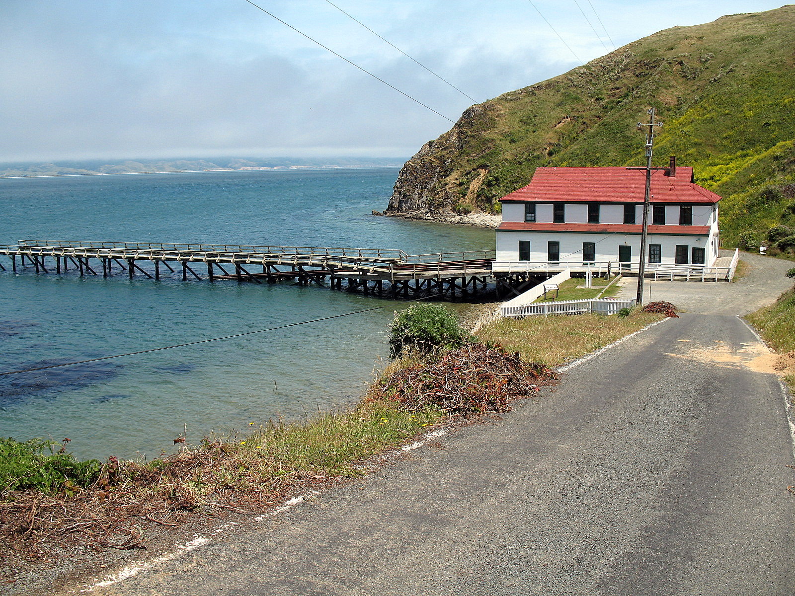
Where the Rescue Boats Waited
Inside the boathouse at the end of the pier, a rescue boat still sits in its launching cradle. CG 36542 has not slid down the rails into Drake's Bay in decades, but the infrastructure that would send it there remains: a hundred feet of iron rails running from the boathouse floor out over wooden planking, then pilings, then sixty feet into the water. The Point Reyes Lifeboat Station was built for a single purpose - pulling sailors out of the sea along one of the most dangerous stretches of the California coast - and its designers left nothing to chance. The boathouse, the rails, the cradles, the living quarters above the boat dock: everything was oriented toward the moment the call came in and a thirty-six-foot motor lifeboat had to hit the water as fast as physics allowed.
A Graveyard Needs Its Keepers
Point Reyes has been sinking ships since Europeans first sailed the California coast in the sixteenth century. The headland juts into the Pacific like a blunt triangle, its southwestern tip splitting into eastern and western projections that create treacherous currents and blind approaches. Fog blankets the peninsula for weeks at a time - by official records, Point Reyes is the foggiest point on the Pacific coast. Gales of seventy-five miles per hour or more strike in most years. Vessels rounding the point often could not see it until they were already in trouble. The United States Lifesaving Service recognized this early. In 1888, it established a station on Ten-Mile Beach, north of the headland, but the site proved problematic - the same dangerous surf that wrecked passing ships also made it treacherous to launch rescue boats. A better location was needed, one sheltered enough for a reliable launch but close enough to reach wrecks quickly.
The Sheltered Side
The solution was elegant: build on the opposite side of the danger. While the Point Reyes Lighthouse sits on the exposed western projection, staring down the Pacific swells, the lifeboat station was placed on the sheltered north side of the eastern projection, facing the calm waters of Drake's Bay. The site was purchased in 1913, but development stalled. World War I diverted resources, and in 1915 the Lifesaving Service merged into the newly formed United States Coast Guard, adding bureaucratic complexity to the delay. Construction finally began, and the station was completed in 1927. The boathouse rose two and a half stories at the end of the pier - a hip-roofed, clapboarded structure that looked more like a New England fishing lodge than a military installation. The ground floor served as the boat dock, housing a standard thirty-six-foot motor lifeboat and a surfboat. The upper floor provided living quarters for the crew. The chief officer lived in a separate building set farther up the hillside to the west, positioned to survey both the station and the bay.
Forty Years on the Rails
For four decades, the station operated on a rhythm dictated by the sea. When a vessel ran into trouble off Point Reyes, the crew slid a rescue boat down the rails and into Drake's Bay, then powered out around the headland to reach the wreck. The thirty-six-foot motor lifeboat was the Coast Guard's standard rescue vessel of the era - heavy enough to handle open ocean swells, small enough to maneuver close to foundering ships. The surfboat served shallower water rescues. Between emergencies, the crew maintained the station, kept watch, and escorted the visitors who came to see the lighthouse across the headland. Life at the station was isolated: the nearest town, Inverness, sat nineteen miles away. Families lived at the station, and dependent children rode three miles by station vehicle to school each day. It was a posting that demanded self-sufficiency and a tolerance for fog.
Outgrown by Progress
By the 1960s, the Coast Guard's fleet had evolved beyond what the Point Reyes station could handle. The new standard rescue vessel was a forty-four-foot motor lifeboat, too large for the boathouse and its rails. Rather than rebuild the station, the Coast Guard shifted rescue operations to a new facility at Bodega Bay, better positioned for the larger boats. The Point Reyes station closed in 1968 after forty-one years of active service. The following year, it was transferred to the National Park Service as part of Point Reyes National Seashore. The station was listed on the National Register of Historic Places in 1985 and designated a National Historic Landmark - one of the best-preserved coastal rescue stations of its period on the Pacific coast.
Rails Into the Water
What makes the Point Reyes Lifeboat Station exceptional among surviving rescue stations is what it still has. Many former lifeboat stations retained their buildings but lost their launching infrastructure - the rails, cradles, and pier structures that were the operational heart of the facility. Point Reyes kept all of it. The rails still run from the boathouse interior out over the pier and into Drake's Bay. The launching cradles sit inside. CG 36542 rests in one of them, an artifact of the station's working years preserved in the exact position it occupied between rescues. The buildings from the original 1888 station on Ten-Mile Beach survive too, repurposed as ranger housing. Even the radio compass building from a period of Navy occupation still stands. Walk the pier today and you can trace the entire sequence: alarm, crew scramble, boat in cradle, cradle on rails, rails into water, boat into bay, bay around the headland, headland into the Pacific, and somewhere out there in the fog, a ship in trouble.
From the Air
Located at 37.99°N, 122.97°W on the Drake's Bay (north-facing) side of Point Reyes, on the sheltered side of the eastern projection of the headland. The boathouse and pier are visible from low altitude on the shore of Drake's Bay. The Point Reyes Lighthouse sits on the exposed western tip approximately two miles southwest. Look for the triangular shape of Point Reyes jutting into the Pacific, with Drake's Bay curving along its northeastern shore. Best viewed below 2,000 feet for structural detail. Nearest airports: Gnoss Field (KDVO) in Novato approximately 22 nm east; San Francisco International (KSFO) approximately 35 nm south. Fog is extremely common; Point Reyes is the foggiest point on the Pacific coast.