Point Reyes Shipwreck Coast
Point Reyes juts into the Pacific like a broken arm, blocking the path of ships entering San Francisco Bay in fog and storm. The headland has earned its reputation as a ships' graveyard - 56 vessels have wrecked along this coast since the 1850s, their bones littering beaches and lying beneath the waves. The most ironic casualty was the Point Reyes itself, a lumber schooner that ran aground on its namesake point in 1897 and was so thoroughly destroyed that only its anchor was salvaged. Today, visitors to Point Reyes National Seashore can see interpretive displays about these maritime disasters and understand why this beautiful coast was once the most feared passage on the California shore.
The Geography
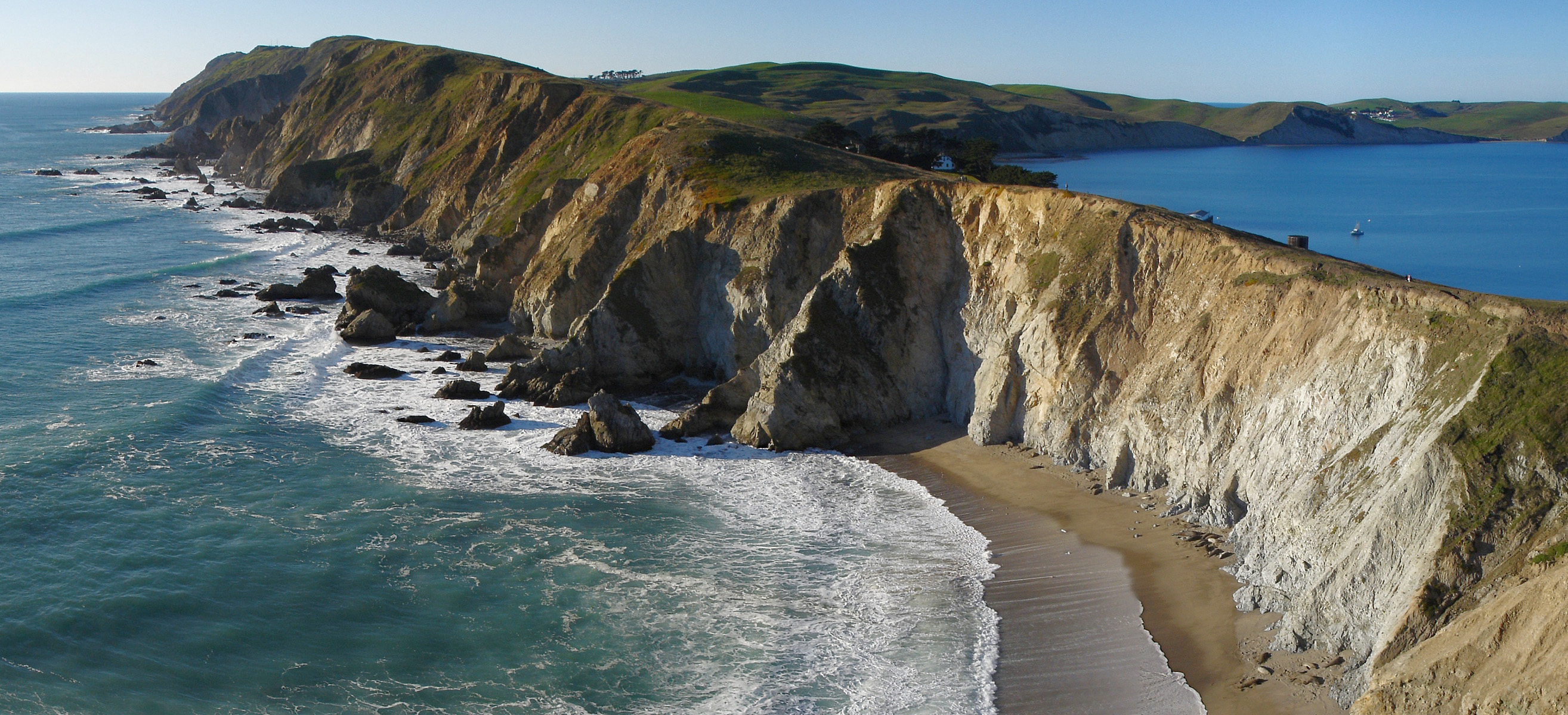
Point Reyes is the windiest place on the Pacific Coast and the second foggiest (after Nantucket). The headland extends 10 miles into the Pacific, directly across the approach to San Francisco Bay. Ships running before storms or groping through fog found Point Reyes before they expected it - rocky cliffs, submerged rocks, and no harbor. The point sits on the Pacific Plate, moving northwest at about 2 inches per year; the mainland is on the North American Plate. This geological instability adds earthquake risk to the navigational hazards. The lighthouse at the point, built in 1870, did little to stop the wrecks - ships still found the rocks.
The Wrecks
Point Reyes has claimed at least 56 ships since records began. The earliest documented wreck was the San Agustín in 1595 - a Spanish galleon that sank in Drake's Bay with a cargo of Chinese porcelain. The wreck wasn't confirmed until porcelain fragments washed up for centuries afterward. The lumber schooner trade in the late 1800s added many casualties - small wooden ships running between northern forests and San Francisco markets. The steamer San Jose wrecked in 1880; the schooner King of the Sea in 1892; the Point Reyes in 1897. The advent of radio, improved navigation, and diesel engines eventually reduced wrecks, but the coast remains dangerous in storm and fog.
The Point Reyes
No wreck is more ironic than that of the schooner Point Reyes. Built in 1881, the 117-foot lumber schooner was named for the headland where it would eventually die. On September 25, 1897, the Point Reyes departed Fort Bragg for San Francisco carrying lumber. Fog enveloped the coast; Captain O.B. Myers misjudged his position. The Point Reyes struck the rocks at its namesake point and broke apart within hours. The crew escaped, but the ship was totally destroyed. Salvagers recovered only the anchor - the ship that shared the point's name became part of the point itself.
The Lighthouse
Point Reyes Lighthouse was built in 1870, positioned 300 feet above the water on the headland's windiest spot. The lighthouse was intended to prevent wrecks, and it likely did save some ships. But fog often hangs below the lighthouse while the beacon shines unseen; the foghorn became essential. The lighthouse keeper's job was miserable - constant wind, fog, isolation, and the knowledge that ships were still wrecking nearby. The lighthouse was automated in 1975 and transferred to the Park Service in 1977. Visitors can descend 300 steps to the lighthouse during whale-watching season or clear weather.
Visiting Point Reyes Shipwreck Sites
Point Reyes National Seashore is located 30 miles northwest of San Francisco via Highway 1. The Bear Valley Visitor Center provides maps and information. The lighthouse (300 steps down) is accessible on clear days and whale-watching season. The shipwreck coast interpretive trail near Tomales Point discusses maritime disasters. No ships are currently visible above water, though anchors and debris occasionally appear. The seashore offers hiking, wildlife viewing (elephant seals, tule elk), and historic sites. Camping is available by permit. San Francisco International Airport is 50 miles south. Point Reyes Station has limited services. Fog is common year-round; dress in layers and bring rain gear.
From the Air
Located at 37.99°N, 122.98°W northwest of San Francisco, California. From altitude, Point Reyes is dramatic - a headland extending sharply into the Pacific, separated from the mainland by the linear trace of the San Andreas Fault (visible as Tomales Bay and Olema Valley). The lighthouse sits at the headland's western tip. Drake's Bay curves southeast of the point. San Francisco is visible 30 miles to the southeast. The fog bank that causes so many wrecks is often visible as a white layer covering the point while inland areas remain clear. The exposed position that makes the point dangerous to ships is apparent from above.