Port Chalmers
In 1882, a ship called Dunedin sailed from Port Chalmers carrying the first cargo of refrigerated meat ever exported from New Zealand. That single voyage transformed the country's economy, proving that a small colony at the bottom of the world could ship perishable goods to markets on the other side of the planet. Port Chalmers has always punched above its weight. With only 1,500 residents, this hilly settlement on the northern shore of Otago Harbour has served as gateway, proving ground, and quiet retreat for over 170 years, though never quite in the way anyone predicted.
From Koputai to Chalmers
The Maori name for the place was Potakere, or Pou-takere, likely referencing the hill where a tuahu, or altar, once stood. A later name, Koputai, means 'full tide' and recalls an incident when rising water set beached canoes adrift. European settlers arriving on the John Wickliffe on 23 March 1848 considered naming the new settlement New Leith or New Musselburgh, rejecting the Maori name in favor of something Scottish. They settled on Port Chalmers, honoring Dr. Thomas Chalmers, leader of the Free Church movement. The older settlement at Otakou, across the harbor, had served as the region's international port, but the arrival of organized European immigration shifted that role here. By January 1854, the population had reached 80.
Gold and Growing Pains
When gold was discovered in Central Otago in 1861, everything changed. Dunedin's harbor was too shallow for the large vessels rushing to supply the diggings, so ships docked at Port Chalmers instead. A community of workers sprang up on the hill overlooking the wharves, and within months the port ranked third-largest in Australasia. The prosperity did not last unchallenged. Dredging of the Victoria Ship Channel eventually allowed bigger vessels to reach Dunedin directly, and Port Chalmers compensated by developing ship servicing, building industries, and fishing at adjacent Carey's Bay. The cycle of reinvention had begun, and it would repeat itself across the next century and a half.
Containers and Cruise Ships
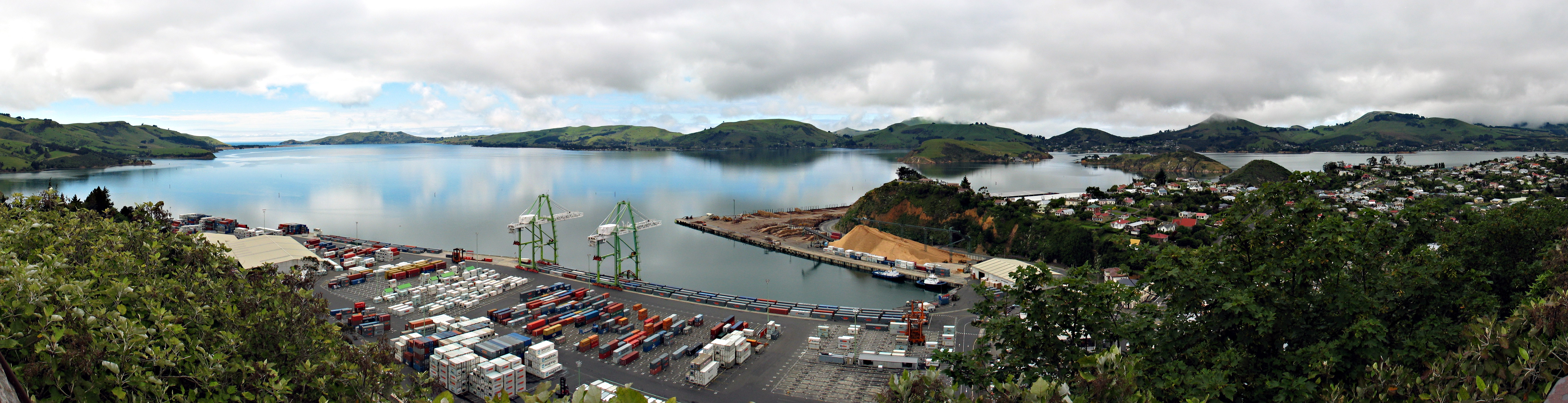
The selection of Port Chalmers as the South Island's first container terminal in 1971 re-established its commercial significance in a way the gold rush never sustained. Stacks of containers now dominate the reclaimed land at the northern end of the peninsula, visible from the Flagstaff Lookout atop Observatory Hill, where the successor to an old signal mast still stands. From that vantage point, you can see logging trucks threading down George Street, the main road that shares its name with Dunedin's own George Street. The Port Chalmers version is numbered in the 5000s to avoid confusion. Cruise ships have added another layer since the 1990s, with 115 vessels bringing 229,000 passengers in 2019 alone. Modern ships are too large to navigate the dredged channel to Dunedin, making Port Chalmers the preferred stop, and each arrival temporarily doubles the town's effective population.
Artists on the Hill
From the 1970s onward, an artists' colony took root in Port Chalmers and Carey's Bay. The combination of affordable housing, harbor light, and physical separation from Dunedin attracted painters, sculptors, and musicians who turned old waterfront buildings into studios and galleries. The town hosts a monthly community market on the Village Green, where locally grown produce, crafts, and coffee compete with buskers for attention. A biannual Seafood Festival in September pairs the harbor's catch with beer and live music, and the Dunedin Marathon finishes here. Live music persists at the Tunnel Hotel and The Galley Cafe and Bar, though the town's nightlife is a shadow of the late 19th century, when nine hotels served a population not much larger than today's.
Between Two Waters
Port Chalmers occupies a small hilly peninsula with the container port on reclaimed land to the north and Quarantine Island and Goat Island lying offshore to the southeast, between the town and the Otago Peninsula across the harbor. The Harbour Cycleway connects Port Chalmers to Dunedin along the shore, and a seasonal ferry links it to Portobello on the peninsula's southern side. From Observatory Hill, the view encompasses the working port below and the volcanic ridgeline of the peninsula beyond. The old railway station is now a trackside grassy patch on Ajax Street, though the scenic Seasider train still stops on request. Logging trucks still rumble past the shops on George Street, a reminder that this remains a working port first, a destination second, and a place where commerce and beauty exist in uneasy proximity.
From the Air
Port Chalmers sits at 45.82S, 170.62E on the northern shore of Otago Harbour, approximately 12 km northeast of central Dunedin. From the air, the container terminal is immediately identifiable by its stacked containers and reclaimed land jutting into the harbor. The narrow harbor channel stretches southeast toward the harbor mouth at Taiaroa Head. Quarantine Island sits in the harbor between Port Chalmers and the Otago Peninsula. Dunedin Airport (NZDN) is about 35 km to the southwest. At 2,000-4,000 feet, the relationship between the working port, the harbor, and the surrounding hills is clearly visible.