Port of Salvador
At the time American colonists were declaring independence from Britain, the harbor at Salvador moved more goods than any port in the soon-to-be United States. Ships from three continents crowded its quays. Sugar and tobacco bound for Lisbon. Enslaved people arriving in chains from West Africa. Gold working its way down from the Minas Gerais interior. For more than two centuries this peninsula on Todos os Santos Bay was the beating commercial heart of Portuguese America, and its wharves have never really stopped working.
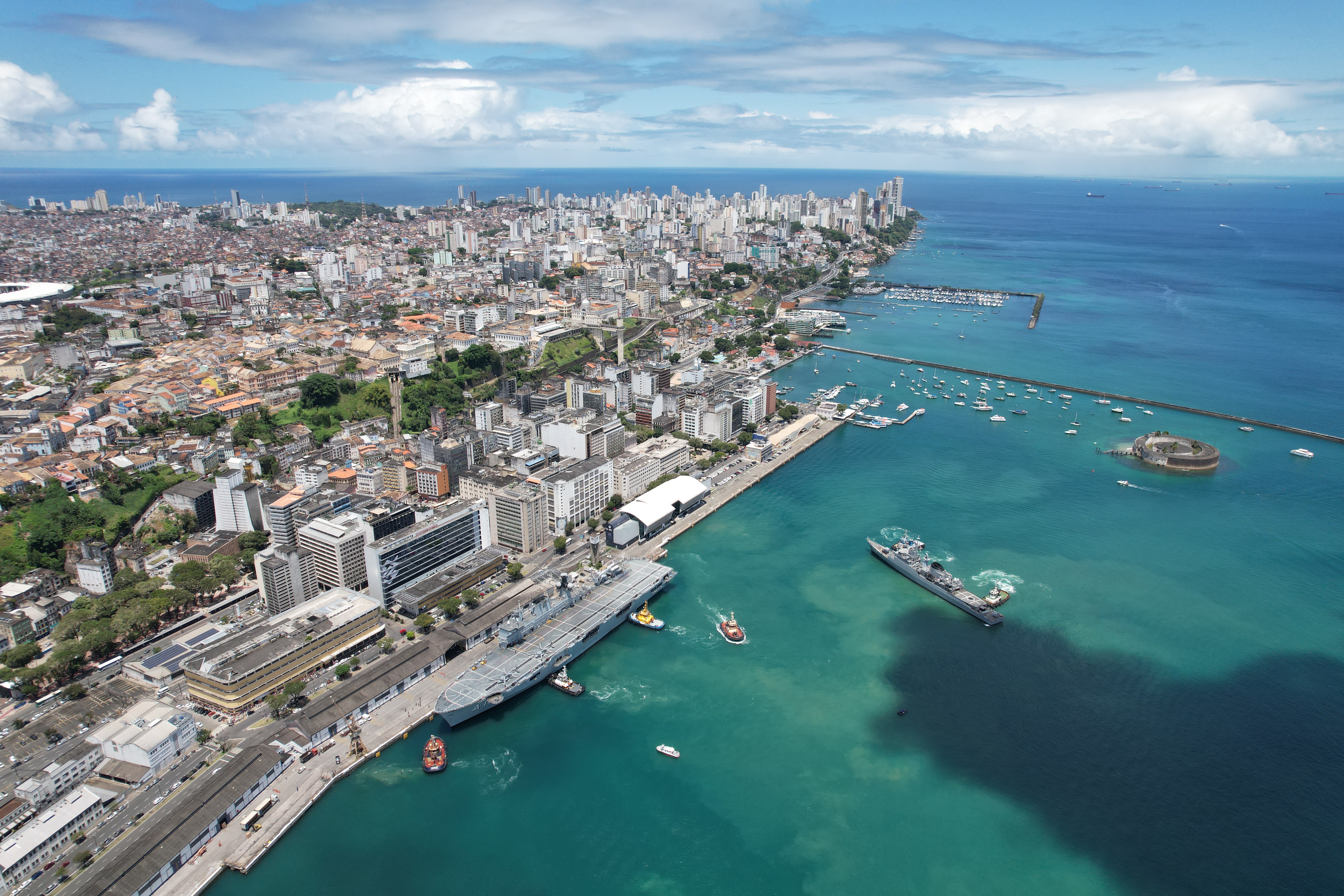
The Shape of the Harbor
Geography made Salvador inevitable. The city sits on the tip of a peninsula that separates Todos os Santos Bay from the open Atlantic, and the bay itself is a vast, sheltered basin nearly fifty kilometers across. Two canals thread ocean-going vessels past the headlands into calm water where tidal swings are modest and the anchorage runs nine to twelve meters deep. The modern port hugs the lower city, the Cidade Baixa, directly beneath the cliff that carries the old colonial capital on its shoulders. Look up from a container berth and you see the pastel bell towers of Pelourinho; look down from Pelourinho and you watch cranes working cellulose, copper, and Bahian granite onto the decks below. Few working ports anywhere live quite so literally in the shadow of a World Heritage Site.
A Capital Built on Cargo
Europeans first entered this harbor in 1502, two years after Pedro Álvares Cabral's landfall further south. In 1549 the Portuguese Crown sent Tomé de Sousa, the colony's first governor-general, to build a city here, and by 1552 Salvador was the seat of the first Catholic bishopric in the Americas. By 1583 more than 1,600 colonists lived on the bluff above the wharves, and the numbers kept climbing. The engine was sugar. The Recôncavo hinterland produced cane in punishing volumes, milled on plantations worked by enslaved Africans, and the port funneled that wealth across the Atlantic. Dutch West India Company forces seized the city in 1624, trying to grab a cut of the trade for themselves. A combined Spanish-Portuguese fleet recaptured it the following year, and Salvador remained Portuguese until Brazilian independence in 1823.
Decline and Return
Everything changed in 1763. That year the Portuguese Crown moved the colonial capital south to Rio de Janeiro, closer to the gold-rich interior and better positioned for trade with the River Plate. The decision drained Salvador of political weight, and the port slid into a long, slow decline that stretched deep into the twentieth century. Revival came in stages. Population surged past 350,000 by 1948. Industrial parks and the Camaçari petrochemical complex rose on the Recôncavo in the early 1970s, and in 1975 the port opened its first modern container terminal. CODEBA, the state company that manages Bahian ports, now runs a facility moving several million tons a year: wheat and chemicals inbound, petrochemicals and Bahian fruit outbound, with dozens of cruise ships each season disgorging passengers onto the Elevador Lacerda.
The City Above, The Port Below
The Pelourinho quarter directly above the port takes its name from the whipping post where enslaved people were once punished in public view. Restored in the 1990s and inscribed by UNESCO as a World Heritage Site, it is now a district of cobblestones, baroque churches, and Afro-Brazilian drumming groups that practice in the street most evenings. The tension between that beauty and the history embedded in its stones is part of what gives Salvador its weight. Down at the waterfront the Mercado Modelo sells dendê oil, acarajé, and carved wooden figures of Candomblé orixás within sight of loading cranes. Cruise passengers spill off gangways into a city whose African heritage is not a museum piece but a living, audible presence. The port moves cargo. The city above it remembers who carried that cargo in centuries past, and sings.
From the Air
Port of Salvador sits at approximately 12.96°S, 38.51°W on the eastern tip of a peninsula separating the Baía de Todos os Santos from the Atlantic. From 8,000-10,000 feet the entire bay reads as a near-circular inland sea dotted with islands. Salvador Bahia Airport (ICAO: SBSV, IATA: SSA) lies about 28 km north-northeast along the coast and handles all commercial traffic into the region. The city itself is built on a bluff, with Cidade Alta riding the ridge above the lower-city waterfront where the port operates. Trade winds are generally from the east-southeast; afternoon cumulus and occasional coastal showers are common year-round, with the wetter months running April through July.