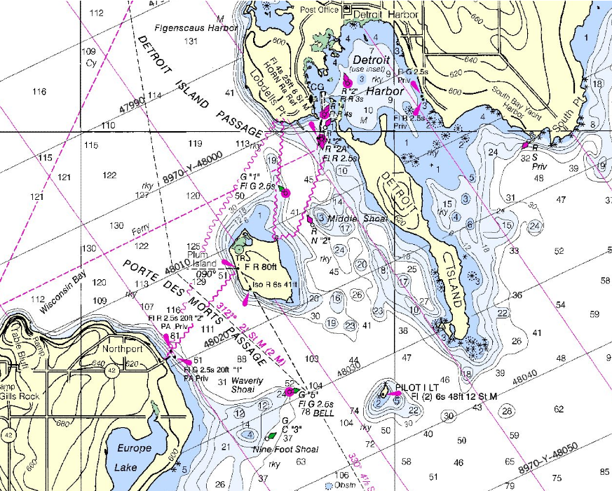
Porte des Morts
The name translates simply: door of the dead. Porte des Morts is a narrow strait at the tip of Wisconsin's Door Peninsula, where Lake Michigan meets Green Bay through a gauntlet of shoals, tiny islands, and winds that can turn lethal without warning. At its tightest point, between Plum Island and the peninsula, the passage squeezes to barely a mile and a third across. This is the waterway that gave Door County its name, a place where the Winnebago (Ho-Chunk) and Potawatomi fought a battle so devastating that both sides concluded the strait itself was cursed. Centuries of shipwrecks only deepened the legend.
A Battle in the Waves
The oral traditions behind the name reach back to the mid-seventeenth century. According to accounts given by Native Americans to area fishermen in the 1840s and recorded by historian Hjalmar R. Holand, the Winnebago had been pushing the Potawatomi off the Door Peninsula and onto the offshore islands. The Potawatomi devised a counterattack: three scouts would infiltrate Winnebago positions and light a signal fire to guide warriors to a safe landing behind enemy lines. But the scouts were captured, and one revealed the plan. The Winnebago turned the strategy against them, lighting a decoy fire on a high bluff with no safe landing. When the Potawatomi canoes arrived in worsening weather, the Winnebago attacked from above. Canoes capsized in the surf and were dashed against rocks. A few Potawatomi climbed to a ledge above the waves, where fighting continued until a massive wave swept everyone into the lake. The Winnebago raiding party sent to attack the now-defenseless Potawatomi villages also vanished in the storm and was never seen again. Both sides lost. The strait earned its name.
Currents beneath the Surface
The hydrology of Porte des Morts adds a hidden dimension to its danger. North of the peninsula, warm water from Green Bay flows outward into Lake Michigan on the surface, while simultaneously, cold lake water pushes into the bay along the bottom. This layered exchange of currents creates unpredictable conditions that compounded the hazards for sailing vessels. The strait is not a single passageway but three: the Porte des Morts Passage south of Plum Island, the Detroit Island Passage to its north, and the shallow, shoal-choked water between Detroit Island and Washington Island. Waves in the passage can exceed those in the open bay or lake by up to two feet, and extreme waves of twenty to twenty-two feet have been recorded. October and November are the worst months, when five-to-ten-foot seas develop thirty-five percent of the time.
The Shipwreck Graveyard
The strait's reputation was built on real losses. The schooner Fleetwing went down in 1888. In 1892, three more vessels joined her on the bottom: the A.P. Nichols, the Forest, and the J.E. Gilmore. Yet Death's Door's fearsome name attracted blame for wrecks that happened elsewhere. The most famous misattribution involves the Griffin, the first European sailing vessel on the upper Great Lakes, which vanished in 1679. Though the Griffin was last seen sailing from Washington Island, she was heading north, away from Death's Door. No verified remains of the Griffin have ever been found. The Louisiana, another ship often linked to the strait, actually beached and burned in Washington Harbor, miles from the passage. Death's Door did not need borrowed tragedies to justify its name, but its reputation was powerful enough to claim them anyway.
The Shortcut Captains Could Not Refuse
For all its danger, Death's Door was used constantly. Vessels sailing between Green Bay ports and destinations along middle to southern Lake Michigan faced a choice: thread the strait or add roughly thirty miles by going around Washington Island. At sailing speeds of five to ten miles per hour in favorable conditions, that detour meant three to six additional hours. Captains chose the risk. This calculus changed in 1878, when the Sturgeon Bay Ship Canal opened, offering a route that bypassed Death's Door entirely and shortened voyages by over a hundred miles. The canal did not kill traffic through the strait, but it gave cautious captains an alternative they had never had.
Death's Door Today
Modern marine electronics have tamed the navigation challenges that terrorized nineteenth-century sailors, and recreational boaters now cross Death's Door routinely. Commercial ferries transit the passage daily, carrying passengers and vehicles from mainland Door County to Washington Island. Great Lakes freighters still pass through on occasion, though most prefer the wider Rock Island Passage to the north. In winter, the strait transforms into something otherworldly: sheets of fragmenting ice form long stringers that extend into Lake Michigan and across the Rock Island Passage. In 2014, a photograph of these ice formations was featured as NASA's Earth Observatory Image of the Day. The doorway to death has become a tourist destination, but the water beneath the ferries still runs in two directions at once, warm above and cold below, as indifferent to human confidence as it was four centuries ago.
From the Air
Located at 45.29N, 86.96W at the northern tip of the Door Peninsula in Wisconsin. The strait is clearly visible from altitude as the narrow water gap between the peninsula and the chain of islands (Plum, Detroit, Washington) stretching into Lake Michigan. Plum Island and tiny Pilot Island sit in the center of the passage. Look for the ferry wake crossing the strait to Washington Island. Nearest airports: Door County Cherryland Airport (KSUE) to the south, Washington Island Airport (2P2) to the north. Winds in this area can be gusty and unpredictable, especially in autumn. Recommended altitude: 3,000-5,000 feet AGL for full strait context including all islands.