Prescott, Arizona
When the great fire of 1900 swept through Whiskey Row, the patrons of the Palace Saloon did not flee. They carried the entire mahogany bar across the street to the courthouse plaza, set it down, and watched the wooden town burn. Then they carried it back. That bar still stands today in the Palace Restaurant and Saloon, Arizona's oldest continuously operating business, and its survival tells you everything about the character of Prescott. This is a city that has burned down, been stripped of its capital status twice, and buried nineteen of its firefighters in a single afternoon -- and kept going.
Gold, Gunfighters, and a Wandering Capital
Prescott owes its existence to gold. In 1863, Joseph R. Walker's party struck gold at Hassayampa Creek, and within months, Ohio railroad magnates had pushed the Arizona Organic Act through Congress, creating the Arizona Territory. Fort Whipple was established near present-day Chino Valley that same year and quickly became the territorial capital. The fort moved south in 1864, and Prescott grew around it -- a raw frontier settlement where the Yavapai people had lived since splitting from Patayan groups around 1300 AD. The territorial capital bounced like a pinball: Prescott in 1864, Tucson in 1867, back to Prescott in 1877, and finally to Phoenix in 1889. Both Virgil Earp and Doc Holliday lived in Prescott before their infamous gunfight at the O.K. Corral. Virgil served as a constable starting in 1878, and Doc Holliday appears in the 1880 census records, placing him squarely in Prescott's wild mix of miners, gamblers, and lawmen.
Brick, Mortar, and the Row That Would Not Die
Several devastating fires in the early 1900s finally convinced Prescott's residents to rebuild their downtown in brick. The result is a compact historic district with 809 buildings on the National Register of Historic Places -- one of the densest concentrations of registered structures in Arizona. Whiskey Row, a single block of Montezuma Street between Gurley and Goodwin, is the beating heart of the old town. The St. Michael's Hotel and the Palace Hotel have stood here since the late 19th century. Nearby sits the Yavapai County Courthouse, surrounded by a shaded plaza of old elm trees where Barry Goldwater launched his 1964 presidential campaign. On the slope of Thumb Butte, Falcon Nest claims the title of tallest house in North America. The Sharlot Hall Museum preserves the territorial era, while the Arizona Pioneers' Home -- opened in 1911 -- once housed a man who claimed to be Billy the Kid, whose remains were exhumed in 2005 for DNA testing.
The World's Oldest Rodeo
Every year in the days leading up to the Fourth of July, Prescott's population nearly doubles. The self-proclaimed World's Oldest Rodeo has run continuously since 1888, and while other rodeos predate it by decades, Prescott claims the distinction of being the first to charge admission and turn the event into a spectator sport -- a claim backed by a 1985 trademark. In the 2010s, the rodeo drew over 35,000 visitors during its week-long run, while some 45,000 people lined the streets for the Rodeo Parade winding through downtown. Also known as Frontier Days, the event was featured in the 1972 Steve McQueen film Junior Bonner. Beyond the rodeo, Prescott hosts the Bluegrass Festival, Cowboy Poets Gathering, Prescott Highland Games, and on New Year's Eve, the Boot Drop -- a giant illuminated cowboy boot lowered from the Palace Restaurant's flagpole on Whiskey Row.
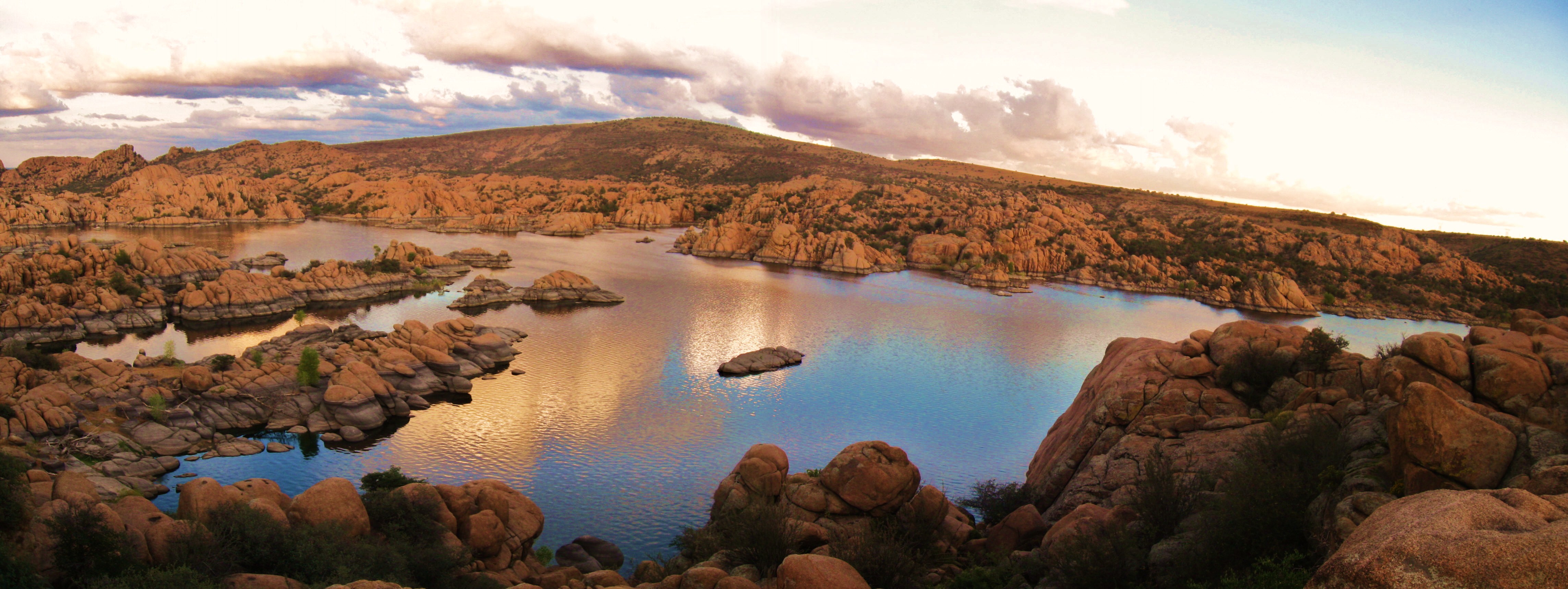
Granite, Water, and Monsoon Fury
Prescott sits at the northern edge of the Bradshaw Mountains, flanked to the east by the Sierra Prieta range. Just north of the city center, the Granite Dells erupt from the landscape -- massive boulders of eroded granite creating a surreal terrain of rounded, bumpy rock formations surrounding Watson and Willow Lakes. The Peavine Trail follows the former rail bed of the Santa Fe, Prescott and Phoenix Railway through this terrain, its name earned from the winding, vine-like curves of the old railroad. Prescott enjoys a Mediterranean climate at its elevated perch, but the North American Monsoon transforms summer into a season of violent drama. Tropical Storm Octave dumped 14.5 inches of rain in less than forty-eight hours in 1983, washing out the Santa Fe Railway in so many places it was permanently abandoned. The Verde River, sometimes bone-dry, surged to half the volume of the Columbia River during the 1891 floods. Flash floods swept away Walker's original mining camp in 1863, barely a year after prospectors arrived.
Above the Pines
From the air, Prescott reveals itself as a green anomaly in Arizona's arid landscape, ringed by ponderosa pines and lakes -- Lynx Lake draws 125,000 visitors annually, and Goldwater, Granite Basin, Watson, and Willow Lakes dot the surrounding hills. Prescott Regional Airport, Ernest A. Love Field (ICAO: KPRC), sits north of the downtown courthouse, with United Airlines serving routes to Denver and Los Angeles. Embry-Riddle Aeronautical University maintains a campus here, making Prescott one of the few small cities in America with both a liberal arts college focused on environmental justice and a top-tier aviation university. The city's elevation gives it a mild four-season climate that has made it a magnet for retirees and outdoor enthusiasts -- and, unexpectedly, a thriving punk rock scene, nurtured by the confluence of recovery community houses, college students, and small-town nonconformity.
From the Air
Prescott is located at 34.585N, 112.447W in central Arizona at approximately 5,400 feet elevation. Prescott Regional Airport, Ernest A. Love Field (KPRC) lies north of the downtown courthouse. The Granite Dells are a distinctive visual landmark north of the city -- look for dramatic rounded boulder formations surrounding two small lakes. Thumb Butte is a prominent rocky outcrop west of town. The Bradshaw Mountains rise to the south, and the Sierra Prieta range extends to the east. SR-89A connects to Sedona and Cottonwood to the northeast. Best viewed at 6,000-8,000 feet AGL. Watch for monsoon weather June through September.