Presidio of Santa Barbara
Spain's empire in the Americas ended here. The Royal Presidio of Santa Barbara, established in 1782, holds the distinction of being the last military outpost built by Spain in the New World. Today, within the reconstructed quadrangle in downtown Santa Barbara, stands El Cuartel, a two-room soldiers' quarters that is the second oldest surviving building in California. Only the chapel at Mission San Juan Capistrano, known as Father Junipero Serra's Church, predates it. The presidio served as the defensive anchor for Spain's Second Military District in California, protecting the coastline that Spanish governors considered vulnerable to foreign attack.
A Strategic Choice
Felipe de Neve, the fourth governor of Las Californias, chose the site for the presidio. He perceived that the coast at Santa Barbara was vulnerable to attack and located a spot near a harbor sheltered from severe storms. The site also offered an ample supply of building materials and water. Construction began on April 21, 1782, and Padre Junipero Serra blessed the site. By 1783, the post had 61 officers and men. The first comandante, Jose Francisco Ortega, planned the fortifications and irrigation works. He obtained livestock from Mission San Buenaventura, established orchards, and began large-scale farming to support the garrison.
Town and Fortress
In 1784, Felipe de Goicoechea took over as comandante, supervising construction of fortifications and living quarters for soldiers and their families. The pueblo of Santa Barbara grew around the presidio, which offered protection for civilian residents. The presidio chapel served as the primary place of worship for the community. Two years after the presidio's founding, construction began on Mission Santa Barbara in 1786, located a mile and a half inland. The mission was mainly intended for use by the native Chumash people after their conversion to Catholicism. The chapel continued serving the town until the 1857 Fort Tejon earthquake destroyed it.
A Soldier's Payment
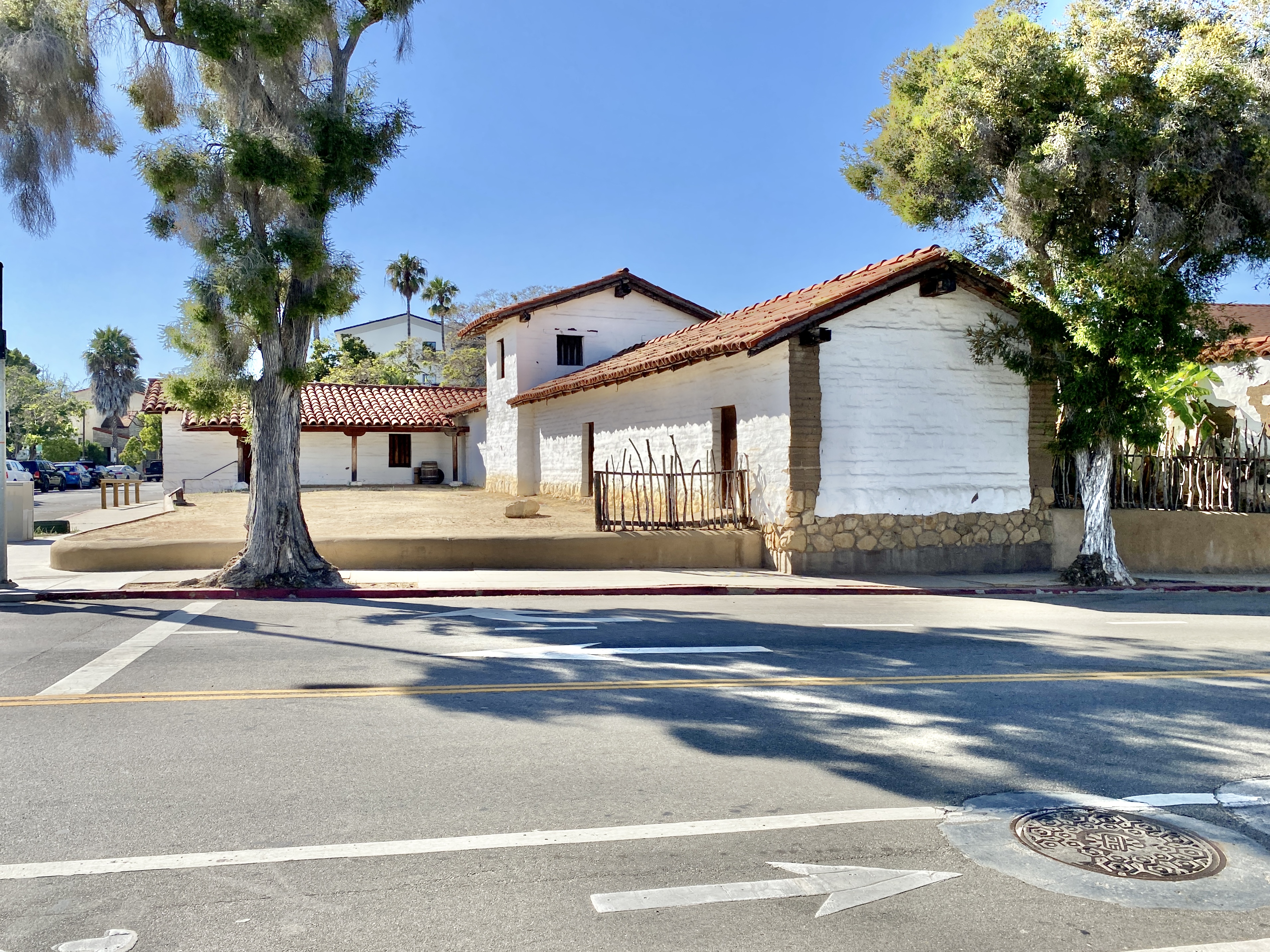
Only two portions of the original presidio quadrangle survive today. The remnants of the two-room soldiers' quarters, called El Cuartel, stands largely unmodified. The other surviving structure is a remnant of the Canedo Adobe, named for Jose Maria Canedo, a Soldado de Cuera, the leather-jacketed soldiers who formed the backbone of Spain's frontier forces. The adobe was deeded to Canedo in lieu of back pay when the presidio fell to inactivity. By the time of the Mexican-American War, very little of the fortress remained in usable condition. The military outpost that had anchored Spanish power on the California coast had become a relic.
Reconstructing the Past
In 1963, the Santa Barbara Trust for Historic Preservation was founded with the primary mission of restoring the presidio. Three years later, the land became a State Historic Park. Work has continued for decades: the trust reconstructed most of the site, with the most recent construction of two rooms in the northwest corner completed in May 2006. The Presidio Chapel and courtyard were completed during the quadrangle reconstruction. The chapel is occasionally used for civic events such as musical concerts and lectures, and Roman Catholic weddings are sometimes performed there with diocesan permission. The Canedo Adobe now serves as the visitor center for the state park.
Trails of History
The Presidio of Santa Barbara was designated a California Historical Landmark in 1958 and added to the U.S. National Register of Historic Places on November 26, 1973. It is now a participating site on the Juan Bautista de Anza National Historic Trail, a National Park Service area commemorating the 1775-1776 expedition that brought settlers from Mexico to establish San Francisco. The presidio in downtown Santa Barbara sits on East Canon Perdido Street, between Anacapa and Garden Streets, across from the Santa Barbara Post Office and about two blocks from city hall and De la Guerra Plaza. Ongoing archaeological work continues to reveal new details about life at Spain's final military outpost in the Americas.
From the Air
The Presidio of Santa Barbara is located at 34.4226N, 119.6971W in downtown Santa Barbara, about half a mile from the waterfront. The reconstructed quadrangle with its red-tile roofs is visible from the air at altitudes of 1,500 to 2,500 feet AGL, though it blends with the surrounding Spanish Colonial architecture of downtown. The nearest airport is Santa Barbara Municipal (KSBA), approximately 7 nautical miles west along the coast. Mission Santa Barbara, with its distinctive twin bell towers, is visible about 1.5 miles inland and provides a useful reference point. The Santa Ynez Mountains rise dramatically behind the city to the north.