Presidio Santa Cruz de Terrenate
The man who built this fortress on a bluff overlooking the San Pedro River had traveled an unlikely path to get here. Hugo Oconor, born Hugh O'Conor in Dublin, Ireland, had risen through the ranks of the Spanish Army to become one of the most capable frontier commanders in New Spain. In 1775, acting on orders from King Charles III, he established Presidio Santa Cruz de Terrenate as a link in the chain of fortresses stretching from Louisiana to California. What Oconor could not have known was that his carefully chosen site sat squarely in the path of Apache raiding routes, a strategic miscalculation that would doom the garrison to five years of desperate struggle before total abandonment.
A Fortress of Leather Soldiers
The men who garrisoned Santa Cruz de Terrenate were soldados de cuera, literally "leather soldiers," named for the seven-layered leather coats they wore as protection against arrows. These frontier troops were among the toughest in the Spanish Empire, but even they could not overcome the challenges that plagued the presidio from its first days. Construction never proceeded according to plan. Crops failed repeatedly in the dry climate. Apache raiders struck the horse herds, leaving the cavalry without mounts. Supply trains of mules were ambushed before they could reach the fortress. The attacks came so frequently that soldiers could barely venture beyond the walls. By 1780, after five years of unrelenting pressure, the garrison abandoned Santa Cruz de Terrenate to the desert.
Layers of Time
Long before Spanish boots trod this ground, other peoples called this place home. The Sobaipuri Indians maintained a settlement here that they called Santa Cruz, a name that would eventually lend itself to both the presidio and the river nearby. Archaeologists have found evidence of even earlier inhabitants. Hohokam pottery sherds erode from the crumbling adobe walls, remnants of a civilization that flourished here centuries before. Stone tools from the Archaic period, some thousands of years old, turn up in the fill of later structures. When Charles DiPeso excavated the site in 1951, he theorized that Colonel Oconor had built directly atop an abandoned Sobaipuri village called Quiburi. Later research by archaeologist Deni Seymour, conducted between 2007 and 2010, refined this understanding, confirming the Sobaipuri presence but identifying the village as Santa Cruz rather than Quiburi.
A Brief American Interlude
For nearly a century after its abandonment, the presidio sat empty, slowly dissolving back into the Arizona desert. Then, in 1878, the United States Army briefly occupied the site. The Apache Wars still raged across southern Arizona, and the old Spanish fortress must have seemed like a convenient outpost. But history repeated itself with eerie precision. Within the same year, the Americans also abandoned Santa Cruz de Terrenate, presumably encountering the same inhospitable conditions that had defeated the Spanish a century before. The ruins returned to silence, preserved by the dry climate that had made life so difficult for its occupants.
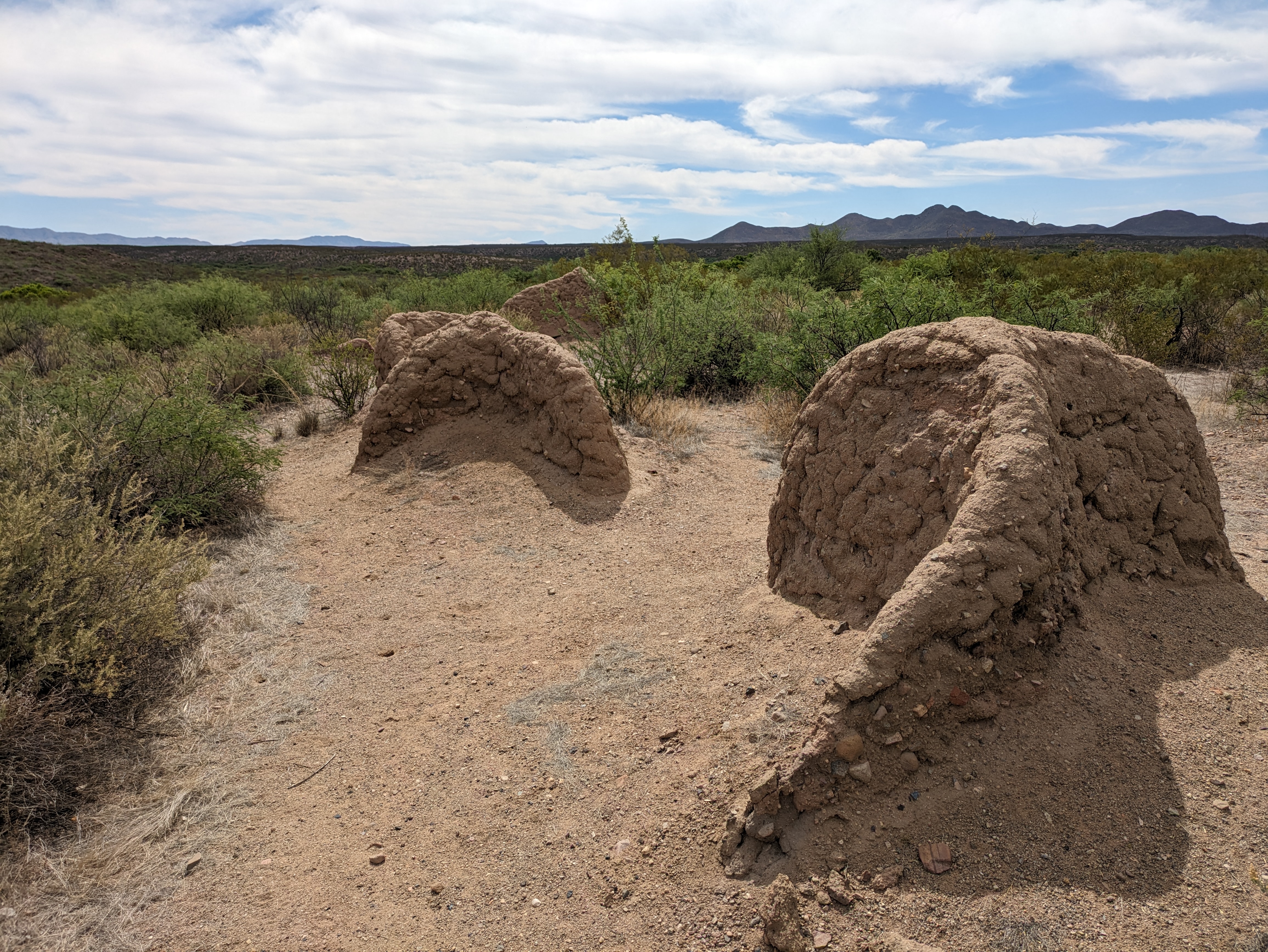
What the Walls Remember
Today, Presidio Santa Cruz de Terrenate stands as one of the best-preserved Spanish colonial military sites in the American Southwest. The adobe walls still rise from the bluff, their earthen construction slowly eroding but remarkably intact for structures nearly 250 years old. This survival is itself a testament to the site's isolation. Located roughly west of Tombstone in Cochise County, the presidio escaped the development that destroyed similar sites elsewhere. Modern archaeological work has revealed details of daily life within the walls: where the soldiers and their families lived, how they attempted to defend against raiders, and the long human history of this place that stretches back thousands of years before the Spanish ever arrived.
From the Air
Located at 31.75N, 110.20W on a bluff overlooking the San Pedro River valley. The ruins are visible from moderate altitude as rectangular earthen formations on the mesa. Approach from the east following the San Pedro River north from the Tombstone area. Nearest airports include Tombstone Municipal (P33) approximately 15 nm east and Sierra Vista Municipal/Libby Army Airfield (KFHU) about 25 nm southeast. Best viewing in morning light when shadows define the wall remnants. Clear weather typical except during summer monsoon season.