Prins Plantation
A Swedish mining engineer named Paulus Printz arrived on Aruba in June 1725, sent by the Amsterdam Chamber of the Dutch West India Company to find gold. He searched for exactly two years -- scrambling across the volcanic hills of the island's interior, testing rock formations, filing reports back to Amsterdam -- before receiving orders to stop. The gold, if it existed, eluded him entirely. Printz departed in June 1727, leaving behind little more than the ruin of his hilltop dwelling and a name. The plantation that grew up in the arroyo below his abandoned house became Plantage Prins, and for generations afterward, coconut palms and fruit trees filled the sheltered ravine where a gold prospector once failed. Today the plantation house is a ruin, the coconuts are gone, and Printz's hilltop dwelling has vanished completely. But the name persists, a monument to ambition that outlasted its object by three centuries.
The Gold That Wasn't
Printz's failure was premature rather than wrong. Nearly a century after he gave up, gold was discovered on Aruba in 1824, triggering a mining boom that would last 92 years and yield 2,962 pounds of exported gold. The deposits turned up at Daimari, Lagabai, Wacobana, Arikok, and Hadicurari -- sites scattered across the same rugged eastern landscape Printz had searched. The Bushiribana gold mill, whose stone ruins still stand on the northern coast, processed ore hauled from these inland deposits. Printz had been looking in the right country, possibly even the right hills, just with the wrong century's technology. His story is a footnote in Aruba's colonial record: a competent engineer defeated by terrain, climate, and the limitations of 18th-century prospecting. Amsterdam lost patience before the island revealed its secret.
The Plantation in the Arroyo
The sheltered ravine below Printz's hilltop proved better suited to agriculture than mining. Wind-sheltered arroyos -- dry streambeds that channel rare rainfall -- create pockets of deeper soil and relative humidity on an otherwise arid island. Prins Plantation occupied one such arroyo, alongside two neighboring ravines called Rooi Prins and Rooi Dwars, where coconut and fruit trees flourished in conditions too harsh for most Caribbean crops. By the time the 1911 Werbata-Jonckheer map was drawn, Prins was one of 23 small plantations identified across Aruba, characterized by mixed agriculture, coconut trees, and modest housing. These were not the grand sugar estates of Jamaica or Barbados. They were smallholdings suited to an arid island -- subsistence operations where families coaxed what they could from rocky soil and intermittent rain. Mr. Mokki Arends eventually owned the Prins property, tending it through the decades when coconut was still a viable crop on the island.
Disease and Decline
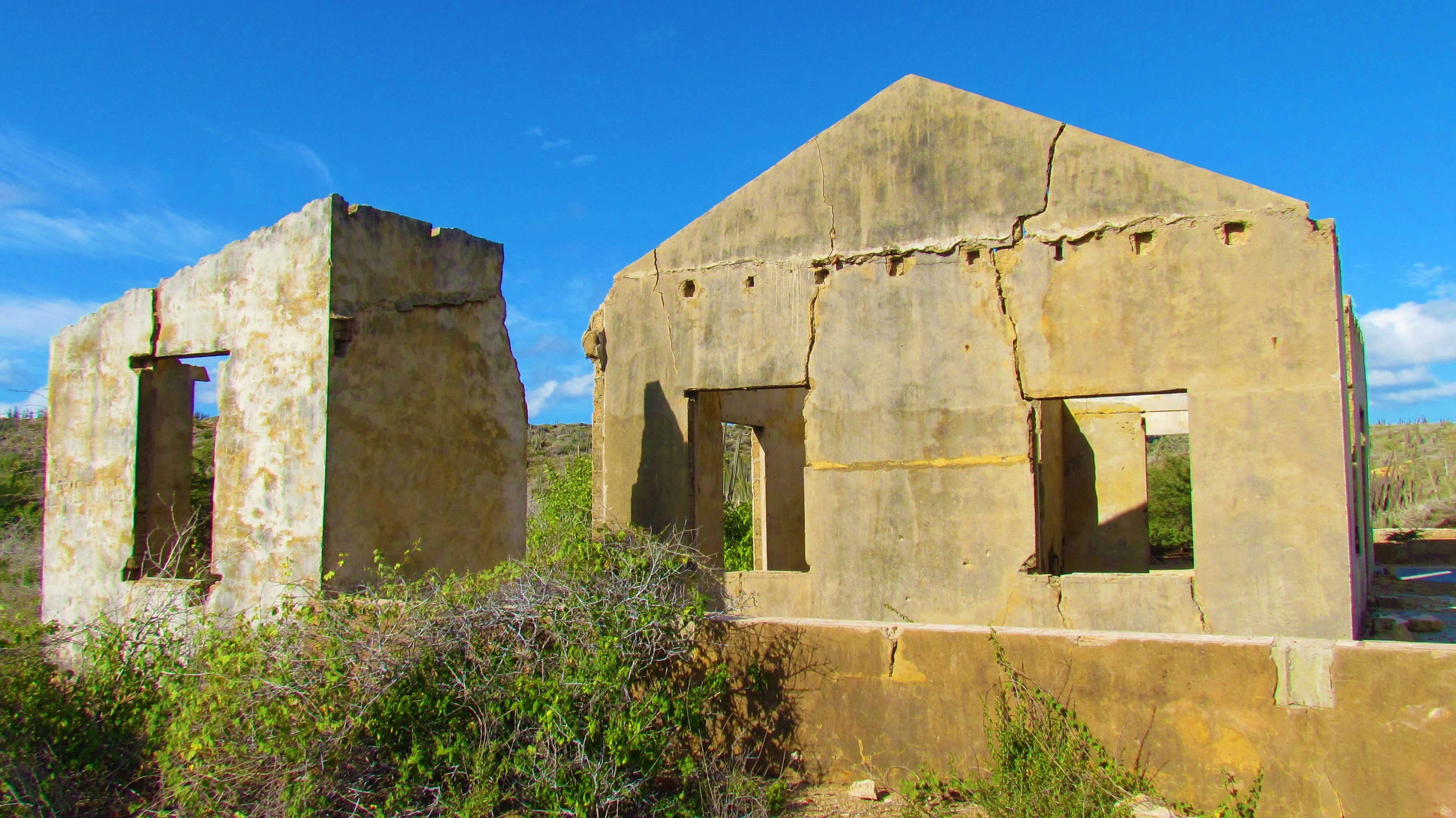
The coconut palms died. Disease -- the specific pathogen is not recorded in surviving accounts -- moved through Aruba's groves and killed the trees that had defined Prins Plantation for generations. Without coconuts, the economic logic of farming a wind-sheltered arroyo collapsed. The original plantation house had already vanished by the time a country house was built on the site in the 1930s, and that replacement structure is now itself a ruin. A few fruit trees survive among the native vegetation that has reclaimed the ravines, growing more densely in the sheltered arroyos than on the surrounding exposed hills. The site sits 2.5 kilometers from the Arikok National Park visitor center and about 600 meters northwest of Fontein Plantation, connected by a trail that winds through the kind of landscape Paulus Printz would still recognize: volcanic hills, limestone terraces, and dry scrub interrupted by the occasional green pocket where water once collected.
A Name Waiting for Purpose
Plans exist to transform the Prins Plantation ruins into the Prins Center, a demonstration site showcasing early plantation agricultural techniques within Arikok National Park. The park already covers roughly 20% of Aruba's land area -- 32 square kilometers of protected terrain -- and the incorporation of agricultural history would add a human dimension to a park better known for its geology and wildlife. As of 2023, the renovation has not occurred. The ruins sit quietly in their arroyo, visited by hikers who follow the trail from the park's visitor center. Nearby, the township of Savaneta -- which itself originated as a governmental plantation before becoming a village -- continues its own slow transformation. Aruba's plantation era left few physical traces. The island pivoted to aloe cultivation, then oil refining, then tourism, each economic chapter overwriting the last. Prins Plantation endures as one of the few sites where the agricultural past remains legible, even if barely -- a ruin named for a gold prospector, built on coconuts, and waiting for someone to decide what it should become next.
From the Air
Located at 12.49N, 69.91W within Arikok National Park on Aruba's eastern coast. The plantation ruins sit in a sheltered arroyo (dry ravine) roughly 2.5 km from the park visitor center. From the air, look for the contrast between exposed volcanic hillsides and the denser vegetation filling the narrow ravines -- these green pockets mark the former plantation arroyos. Fontein Plantation is 600m to the southeast. Queen Beatrix International Airport (TNCA/AUA) lies approximately 10 km to the west. The site is best appreciated at lower altitudes (1,500-3,000 ft) where the arroyo vegetation patterns become visible against the brown hillsides. Persistent trade winds from the east-northeast; generally clear with good visibility.