Providence Canyon State Park
The gullies that would become Georgia's most dramatic geological feature started as simple furrows in a farmer's field. In the early 1800s, settlers poured into Stewart County after the Treaty of Indian Springs forced the Creek Indians to cede their lands east of the Chattahoochee River. They cleared the trees, planted row crops, and paid no mind to erosion. The soil had other plans. Within decades, rainwater cut through layers of soft marine sediments, carving canyons that now plunge more than 150 feet into the earth. Today, Providence Canyon State Park protects 1,109 acres of these accidental wonders, and the state counts them among the Seven Natural Wonders of Georgia.
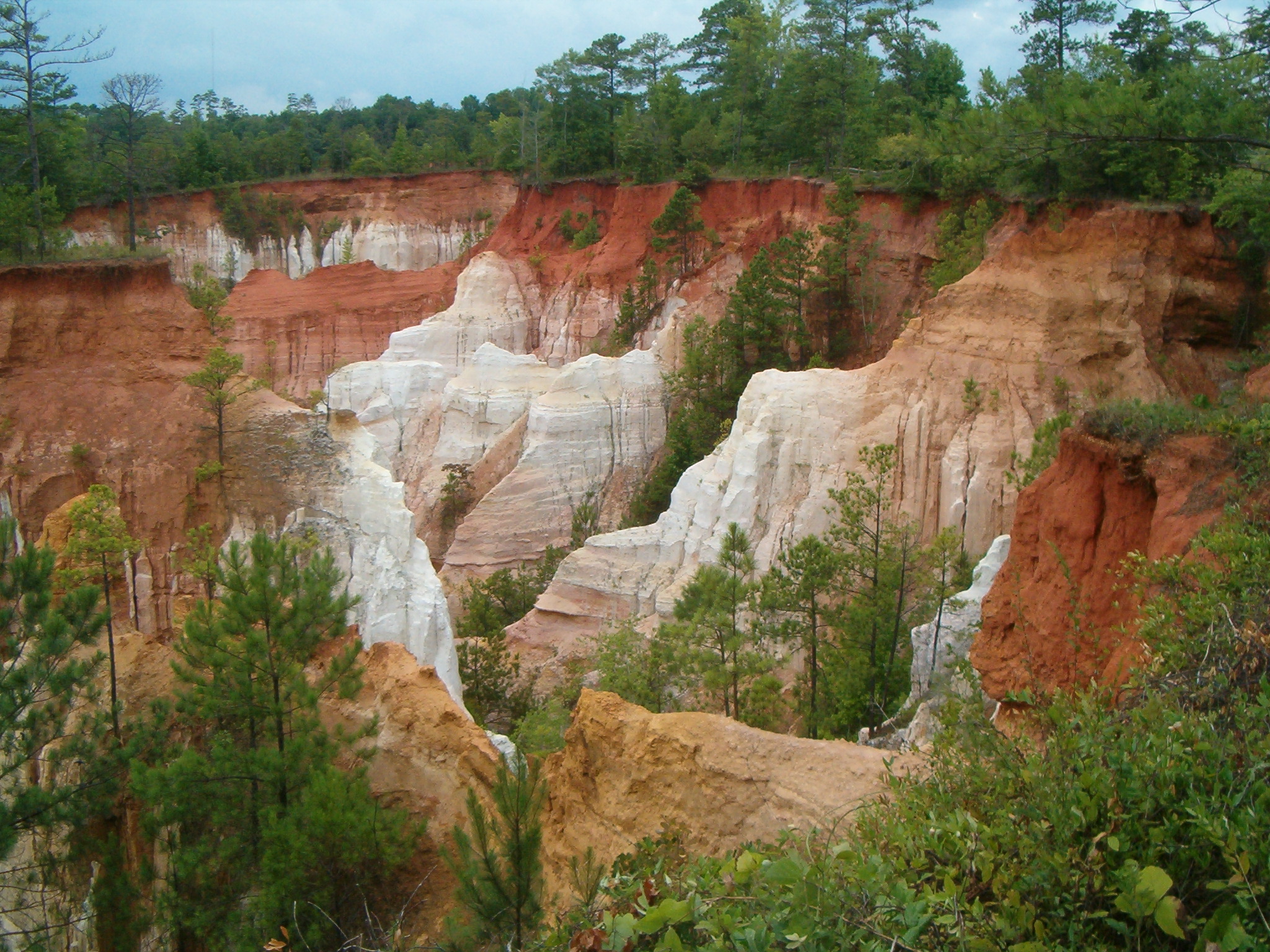
Mistakes Made Beautiful
Providence Canyon is not what it appears to be. Visitors expecting a primordial landscape are actually walking through one of the most spectacular examples of soil erosion in the eastern United States. The 16 canyons within the park expose vivid bands of clay, sand, and loam in shades of red, orange, pink, and white, the result of millions of years of marine sediment deposition sliced open in barely two centuries. But the story is more nuanced than simple human carelessness. A deed from 1836, just eleven years after settlers arrived, already mentions the canyons, suggesting that some formations were at least partially natural. Poor farming practices accelerated and deepened what nature had begun, transforming modest gullies into a canyon system that earns its nickname: Georgia's Little Grand Canyon.
A Flower That Waited
While the canyons draw the crowds, botanists come for something rarer. Providence Canyon harbors the largest wild population of the plumleaf azalea in the world. Rhododendron prunifolium grows nowhere else in significant numbers, a shrub that reaches 15 feet at maturity and holds its orange-red blooms until July and August, long after every other azalea has faded. The timing is deliberate in evolutionary terms: by flowering when no other azaleas compete, the plumleaf commands the full attention of its pollinators. Each October, the park celebrates Fall Wildflower Day, but the plumleaf's midsummer display is the real botanical event, a flash of color against the canyon's exposed clay walls that has likely been repeating for millennia.
Rust and Memory
One of the park's most unexpected sights has nothing to do with geology or botany. An abandoned homestead near the canyon rim includes nearly a dozen rusting 1950s-era cars and trucks, left exactly where their owners parked them decades ago. Park officials considered removing the vehicles but determined that the environmental damage of extraction would outweigh the cosmetic benefit of a cleaner landscape. So the cars remain, slowly dissolving into the red earth, their chrome fenders and running boards becoming part of the terrain. It is an oddly fitting monument in a place defined by the unintended consequences of human activity, a reminder that what people leave behind can become inseparable from the land itself.
Layers Beneath Your Feet
The park sits on ancient marine sediments laid down when this part of Georgia lay beneath a shallow sea. Loamy sand topsoils give way to subsoils of sandy clay loam and clay, creating the striped canyon walls that shift color with the light. Water moves easily through the well-drained upper layers but seeps visibly over the clay exposures below, carving new channels with every rainstorm. The geology is still active: Providence Canyon continues to deepen and widen, a process that will not stop as long as rain falls on soft sediment. Visitors hiking the canyon floor walk through a landscape that looked different last year and will look different next year, one of the few places in the Southeast where geological change operates on a human timescale.
From the Air
Providence Canyon is located at 32.06N, 84.92W in Stewart County, southwest Georgia. The canyon system is striking from the air, with exposed bands of red, orange, and white sediment contrasting sharply against surrounding green forest. Nearest airport is the private strip near Lumpkin; Southwest Georgia Regional Airport (KABY) in Albany is roughly 50 miles southeast. Columbus Metropolitan Airport (KCSG) is about 40 miles north. Best viewed at 2,000-3,000 feet AGL on clear days; the canyon gashes are visible and dramatic from above.