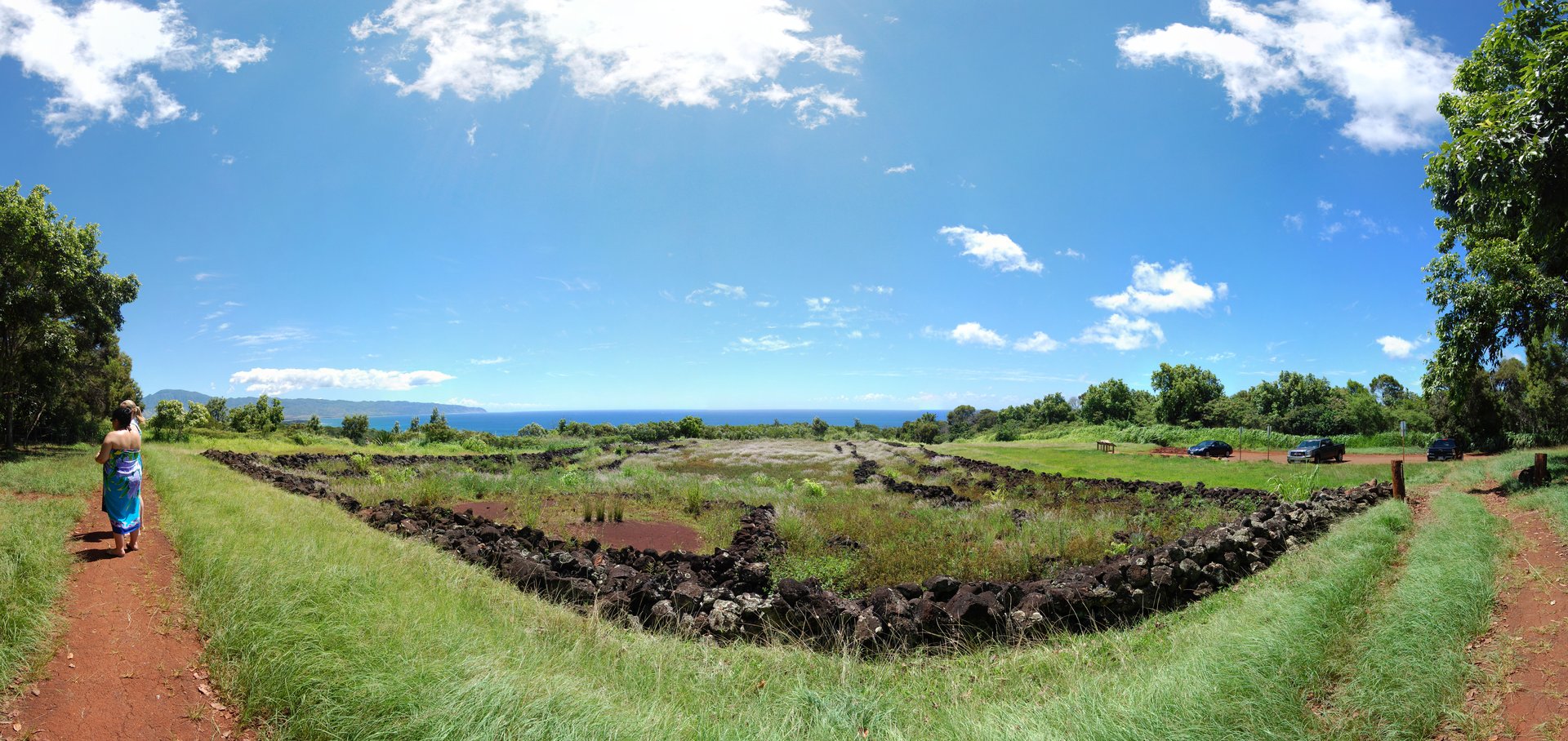
Pu'u o Mahuka Heiau State Monument
Hawaiian legend says the volcano goddess Pele leaped from this hilltop to the island of Molokai. Standing at Pu'u o Mahuka -- the "Hill of Escape" -- you understand the impulse. The two-acre temple complex crowns a ridge above Oahu's North Shore with views so commanding that ancient sentries could monitor the entire northern coastline and, on clear days, spot signal fires blazing from the Wailua Complex of Heiaus on Kauai, some seventy miles across open ocean. This is the largest heiau on Oahu, and its stone walls have absorbed centuries of prayer, sacrifice, and political upheaval.
Walls Built for War
The heiau's three walled enclosures rise in tiers up the hillside. The highest and oldest platform may date to the 17th century, with the two lower enclosures added during the turbulent 18th century. The upper platform functioned as a luakini heiau -- a sacrificial temple dedicated to the war god Ku, where offerings were made to ensure victory in battle. During the 1770s, the temple's overseer was Kaopulupulu, the high priest serving Kahahana, the last independent high chief of Oahu. These were years of constant conflict between island chiefs, and the heiau sat at the intersection of religion, politics, and warfare in a way that no clean distinction between the three could hold.
Blood on the Shore Below
In 1792, the British explorer George Vancouver sent his ship HMS Daedalus to anchor near Waimea Bay to take on fresh water. Three men from the shore party were killed in a skirmish with Native Hawaiians. Archaeologist J. Gilbert McAllister, writing in the 1930s, noted it was "probable" that the bodies were then carried up the hill to the heiau as human sacrifices. The incident captures the violence of the contact era, when European expeditions and Hawaiian power structures collided with lethal consequences for both sides. Just thirteen years earlier, Captain Charles Clerke had stopped at this same bay during James Cook's third voyage -- only two weeks after Cook himself was killed at Kealakekua Bay on the Big Island.
The Last Ceremonies
After Kamehameha I conquered Oahu in 1795, his high priest Hewahewa led religious ceremonies at Pu'u o Mahuka. The temple remained active until 1819, when the traditional kapu system -- the elaborate set of sacred laws governing Hawaiian life -- was abolished by Kamehameha's successor. The abolition dismantled the religious framework that had sustained the heiau for centuries. No more sacrifices were offered, no more priests chanted from the upper platform at dawn. The stones remained, but the rituals that had given them meaning fell silent. The heiau was designated a National Historic Landmark in 1962 and added to the National Register of Historic Places in 1966, enclosed within a four-acre state park.
Stars Over the Temple
One of the heiau's most remarkable qualities is astronomical. At the start of Makahiki -- the four-month Hawaiian New Year celebration honoring the god Lono -- an observer standing at Kaena Point on Oahu's western tip would see the Pleiades, known in Hawaiian as Makalii, rising directly out of Pu'u o Mahuka Heiau just after sunset. This alignment was no accident. The heiau's position linked earth and sky, tying the temple to the celestial calendar that governed planting, harvest, and the cessation of warfare during the Makahiki season. Today the stone walls still catch the evening light above Waimea Bay, and visitors leave offerings of ti leaves and flowers on the altar stones. Roosters -- descendants of the chickens that have roamed Hawaiian archaeological sites for generations -- patrol the grounds with proprietary confidence.
From the Air
Located at 21.645N, 158.062W on a hilltop above Waimea Bay on Oahu's North Shore. The heiau sits on a ridge east of Waimea Valley, accessible from Pupukea Homestead Road. From the air, look for the cleared hilltop with stone wall outlines above the bay. The prominent Waimea Bay crescent and the Waianae Mountain range provide visual references. Nearest airport: Dillingham Airfield (PHDH), approximately 12 nm west. Honolulu International (PHNL) is roughly 28 nm south-southeast. Best viewed at low altitude from over the ocean, looking inland.