Puerto Rico Trench
Somewhere beneath the ocean surface north of Puerto Rico, the rock is so dense it bends gravity itself. NASA has documented the anomaly: a mass concentration beneath the Puerto Rico Trench deflects gravitational pull on the surface of the water, causing the ocean to dip slightly - a visible sag in the sea that throws off navigational instruments. This is a place where the ordinary rules of the planet's surface begin to break down, where the Atlantic Ocean reaches its absolute deepest point, and where two tectonic plates grind past each other with enough stored energy to unleash tsunamis that could reshape Caribbean coastlines.
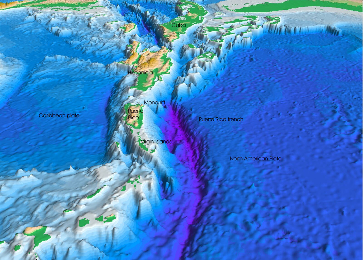
The Atlantic's Deepest Scar
The Puerto Rico Trench runs 810 kilometers along the boundary between the North Atlantic Ocean and the Caribbean Sea, parallel to and north of Puerto Rico. Its maximum documented depth falls between 8,376 and 8,740 meters, depending on the measurement method - deep enough to submerge Mount Everest with more than a kilometer of water above its summit. The deepest point is known as the Milwaukee Deep, though the name Brownson Deep is sometimes used interchangeably for both the point itself and the surrounding seafloor.
In December 2018, American explorer Victor Vescovo piloted the submersible DSV Limiting Factor to the bottom as part of the Five Deeps Expedition, reaching 8,376 meters. He became the first person to touch the floor of the Atlantic Ocean, making what was then the second-deepest solo dive in recorded history. The support ship DSSV Pressure Drop had mapped the exact deepest point earlier that year using Kongsberg EM124 multibeam sonar. What Vescovo found at the bottom: darkness, crushing pressure, and swarms of amphipods - tiny crustaceans thriving in conditions that would kill almost anything else.
Plates in Collision
The trench marks one of the planet's most complex tectonic boundaries. The North American plate slides westward beneath the Caribbean plate in an oblique subduction zone - not diving cleanly under but scraping sideways, combining subduction with strike-slip faulting. To the southeast, the South American plate subducts more directly beneath the Caribbean plate along the Lesser Antilles zone, feeding the chain of active volcanoes that arcs from Grenada to Guadeloupe.
Puerto Rico, the Virgin Islands, Hispaniola, Cuba, and Jamaica all began as volcanic islands but haven't seen eruptions in roughly 30 million years. The volcanoes are extinct; the earthquake risk is not. The Puerto Rico Trench has produced quakes exceeding magnitude 8.0, and the subduction zone has not fully ruptured in over 200 years. Geophysicists consider it overdue. The Caribbean plate moves eastward relative to the North American plate at about 20 millimeters per year - slow enough to measure in fingernail growth, fast enough to store catastrophic energy over centuries.
Tsunamis Past and Pending
On October 11, 1918, a major earthquake along a strike-slip fault near the Mona Passage sent a tsunami crashing into Puerto Rico's western coast. It was a devastating reminder that the Caribbean, for all its resort-brochure serenity, sits on one of the most seismically active boundaries in the Western Hemisphere.
The Puerto Rican Seismic Society has been trying since 1988 to raise public awareness of the tsunami threat, with limited success. The 2004 Indian Ocean disaster, which killed over 200,000 people across forty countries, finally moved Caribbean governments to action. Emergency planning accelerated. The United States government increased seismic investigations around Puerto Rico and the U.S. Virgin Islands, and tsunami warning systems have been developed for the region. But awareness remains uneven, and the trench's seismic potential is not fully understood. A January 2014 magnitude 6.4 earthquake north of Puerto Rico - caused by oblique-thrust faulting consistent with the subduction zone interface - was a sharp reminder that the plates continue to move.
Life in the Abyss
In 2012, a robotic vehicle descended into the trench and captured the first video footage of life at the Atlantic's deepest point. The scene was dominated by benthic amphipods - scavenging crustaceans swarming in the darkness. Scientists collected specimens using bait bags and identified them as Scopelocheirus schellenbergi, a species of lysianassid amphipod previously known only from ultradeep trenches in the Pacific Ocean. Finding them in the Atlantic raised questions about how deep-sea species disperse across ocean basins separated by thousands of miles of shallower water.
Two other creatures appeared in the footage: a soft, dark animal identified by Dr. Stace Beaulieu of the Woods Hole Oceanographic Institution as a sea cucumber of the genus Peniagone, and a small crustacean from the Munnopsidae family of isopods, later identified as Bathyopsurus nybelini based on specimens collected in 2024. The trench is not lifeless - it hosts an ecosystem adapted to pressures that would crush a submarine, temperatures barely above freezing, and total darkness. Life, it turns out, finds even the Atlantic's basement acceptable.
From the Air
Located at approximately 19.84N, 66.75W, running east-west parallel to and north of Puerto Rico. The trench itself is invisible from the surface - the ocean gives no visual indication of the 8,000+ meter depth beneath. However, the geographic context is dramatic: Puerto Rico's north coast is visible to the south, with the Lesser Antilles island arc curving southeast. The trench extends roughly from the Mona Passage (between Puerto Rico and Hispaniola) eastward past the Virgin Islands. Nearest major airports: Luis Munoz Marin International (TJSJ/SJU) in San Juan, Puerto Rico. At cruising altitude, you're flying over the deepest water in the entire Atlantic Ocean. The gravitational anomaly beneath is undetectable from the cockpit but may affect precision navigation instruments.