Puget Sound
From the air, Puget Sound looks like the earth cracked open and the sea rushed in - which is essentially what happened. Glaciers carved this 100-mile-long fjord system 14,000 years ago, scooping out channels hundreds of feet deep, leaving behind a maze of islands, peninsulas, and protected harbors. Today the Salish Sea - as the waters from the Strait of Juan de Fuca through Puget Sound are now officially known - remains the watery heart of the Pacific Northwest, home to 4 million people, a fleet of ferries, resident orca pods, and a culture shaped as much by water as by land.
The Mosquito Fleet's Legacy
Before highways, before bridges, there were boats. For thousands of years, the Suquamish and other Coast Salish peoples navigated these waters in cedar canoes. When settlers arrived, they too turned to the water, creating the 'Mosquito Fleet' - scores of small steamers that buzzed between communities, the primary transportation network of the early Pacific Northwest.
Today's Washington State Ferries inherited this tradition, operating the largest ferry system in the United States. The green-and-white vessels have become symbols of the region, their horn blasts echoing across harbors from Tacoma to the San Juan Islands. Miss the last ferry to your island and you're spending an unplanned night - a reality that shapes island life, forcing a slower rhythm on communities accustomed to waiting for the next boat.
Mountains and Water
The geography of Puget Sound is defined by what rises around it. To the west, the Olympic Mountains catch Pacific storms and wring them dry, creating rainforests on their western slopes and the Olympic rain shadow on their eastern. To the east, the Cascades form a volcanic wall, with Mount Rainier - 'Tahoma' to the people who lived here first - dominating the southern horizon, holding more snow and ice than all other Cascade volcanoes combined.
Between these ranges, the Sound creates its own weather. Marine air flows through gaps in the Olympics, bringing fog and drizzle that Seattleites have learned to call 'The Grey.' But the payoff comes on clear days, when the water sparkles and the mountains seem close enough to touch, and locals understand why they tolerate the clouds.
Creatures of the Deep
Puget Sound teems with life in ways that surprise visitors accustomed to the emptiness of open ocean. Giant Pacific octopus hide in rocky crevices, intelligent enough to recognize individual divers. Wolf eels peer from dens with faces only a mother could love. Bald eagles wheel overhead while harbor seals haul out on rocky islets and sea lions bark from the buoys.
But the stars of the Sound are the orcas. Three resident pods - J, K, and L - have patrolled these waters for generations, hunting the salmon that still run through the strait. Scientists know individual whales by the unique patterns of their saddle patches, tracking family trees across decades. The sight of a black fin breaking the surface, the explosive exhale of a surfacing whale, remains one of the Pacific Northwest's most powerful experiences.
Island Hopping
The Sound contains hundreds of islands, from major population centers like Bainbridge to uninhabited rocks visible only at low tide. Some, like Blake Island - birthplace of Chief Seattle - are accessible only by boat. Others, like Whidbey and Camano, connect to the mainland by bridge. The San Juan Islands to the north require longer ferry rides, their distance from Seattle creating a feeling of true escape.
Each island has its own character. Bainbridge draws Seattle commuters willing to trade 35 minutes on a ferry for the illusion of rural life. Vashon remains stubbornly bohemian, its lack of bridge ensuring that only the determined arrive. Orcas Island hosts artists and retirees in equal measure. But all share the island sensibility - the knowledge that water separates them from the mainland, and that this separation is precisely the point.
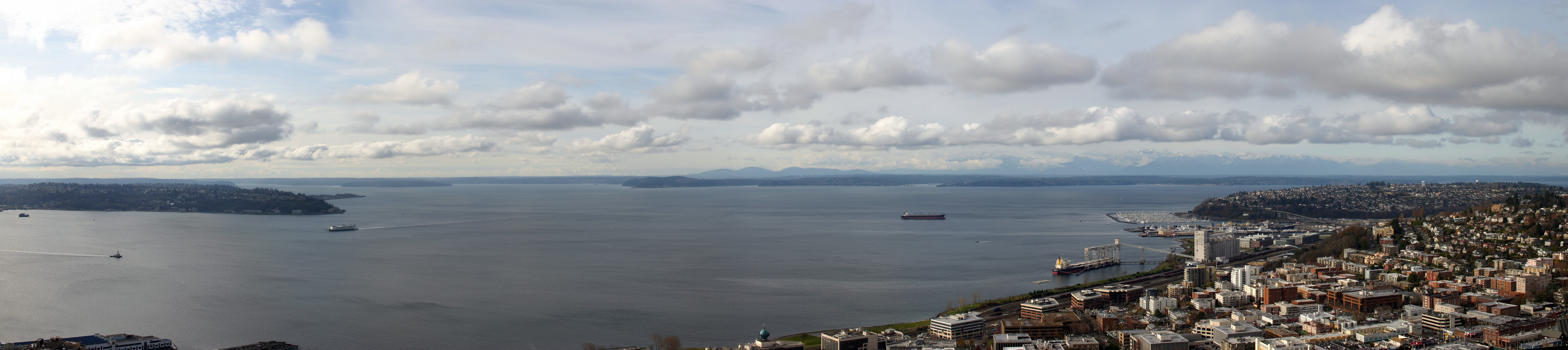
From the Air
Located at 47.83N, 122.43W, Puget Sound is the dominant geographic feature of western Washington. The fjord system stretches roughly 100 miles from Olympia north to the Strait of Juan de Fuca. From altitude, the complex shoreline, numerous islands, and ferry routes are clearly visible. Seattle's waterfront sits on the eastern shore; the Olympic Mountains rise to the west. Mount Rainier dominates the southern horizon. Look for the distinctive green-and-white Washington State Ferries crossing between terminals. The dark water can appear almost black from altitude, contrasting with the lighter Strait of Juan de Fuca to the north.