Punta Gallinas
The continent ends not in a dramatic cliff or a crashing headland but in sand. At 12 degrees, 27 minutes north, the Guajira Peninsula tapers to a windswept point where golden dunes slope into turquoise water and the Caribbean stretches unbroken to the horizon. This is Punta Gallinas, the northernmost tip of South America, and reaching it requires commitment. There are no paved roads for the final stretch, no resort complexes, no airport. Most visitors arrive by a combination of rough overland track and three-hour boat ride from Puerto Bolivar, navigating a landscape so arid it holds the record as the driest region in Colombia. What waits at the end is not comfort but contrast: the stark beauty of desert crashing into ocean, watched over by a solitary lighthouse and a scattering of Wayuu rancherias whose inhabitants have lived here far longer than any map has marked the spot.
Where the Dunes Meet the Waves
The Dunas de Taroa are the visual centerpiece of Punta Gallinas - towering sand formations roughly 50 meters high that tumble directly into the Caribbean Sea. The effect is surreal. On one side, baking desert in every shade of gold and ochre, shaped by the relentless trade winds into ridges and bowls. On the other, the cool blue-green water lapping at the base of the dunes as if the ocean were slowly drinking the desert away.
The contrast exists because the Guajira Peninsula is, geologically and climatically, an extension of the Caribbean's arid zone rather than the tropical South America most travelers imagine. Temperatures swing between 27 and 32 degrees Celsius year-round, spiking to 45 in the interior desert. Rain falls almost exclusively between September and December, and even then sparingly. The landscape is scrub, cactus, and bare earth for hundreds of kilometers, broken only by the occasional dry riverbed. Then, at the continent's edge, the sand gathers into these improbable dunes and spills into the sea.
The Wayuu Coast
About a hundred Wayuu families live in the area around Punta Gallinas, organized into rancherias - small clusters of homes that serve as extended family compounds. The Wayuu are Colombia's largest indigenous group, numbering over 400,000 across the La Guajira department, and their society is matriarchal. Clan identity, property, and children pass through the mother's line. Disputes are settled by palabreros, professional mediators whose role is recognized by UNESCO as intangible cultural heritage.
The Wayuu language, Wayuunaiki, is the first language here, not Spanish. Visitors are guests in Wayuu territory, and the communities that host travelers do so on their own terms - providing hammocks, meals of goat and rice, and guided walks to the lighthouse and dunes. The notion that the Wayuu are dangerous is a myth born of ignorance. In practice, they are curious, hospitable, and direct. They are also vigorous defenders of their land and water rights in a region where drought is not an anomaly but the default condition of life.
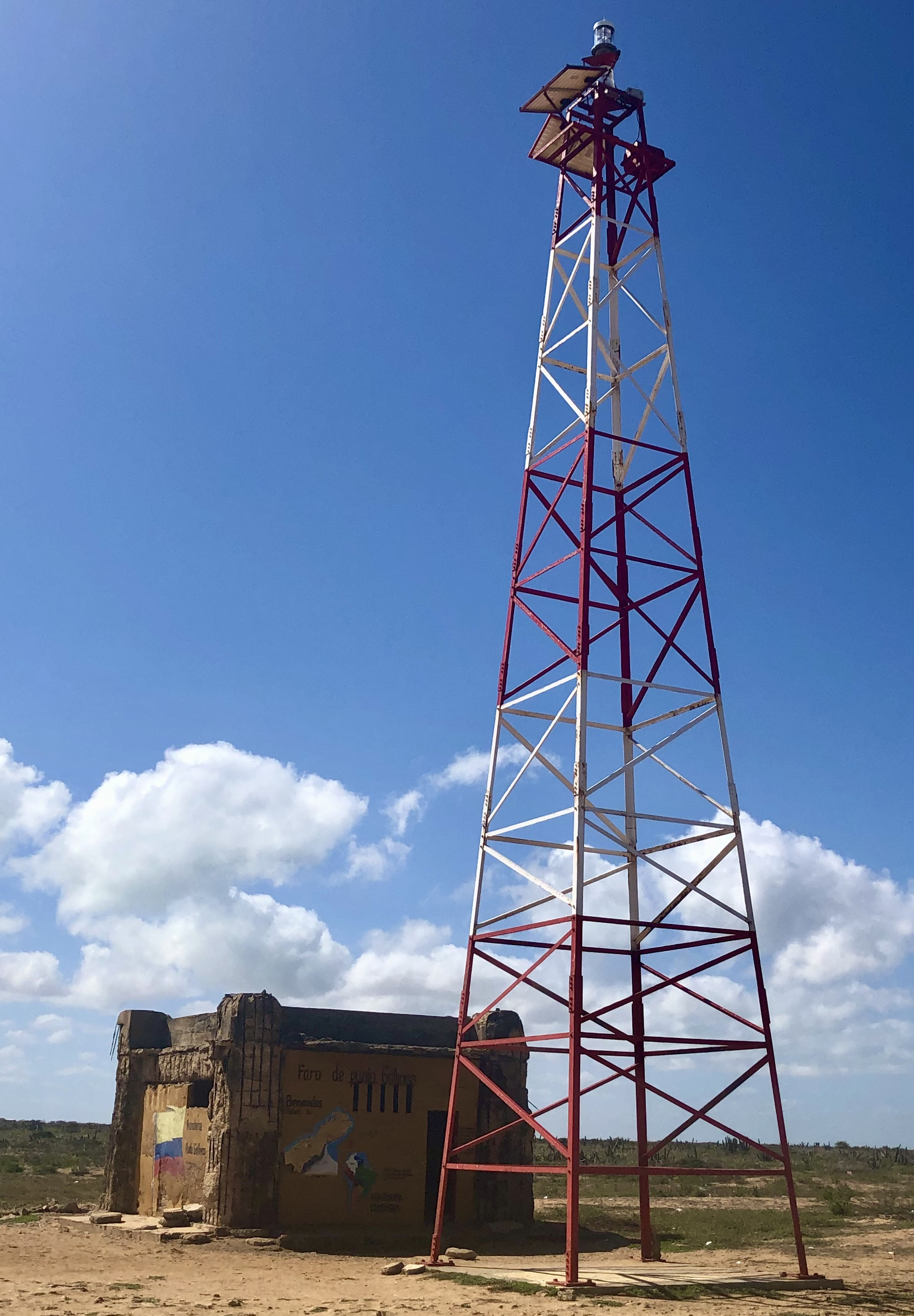
The Lighthouse at the Edge
The Faro de Punta Gallinas stands 18 meters tall, a white column planted on the headland in 1989 to mark the northernmost point of the continent for passing ships. It is not a grand structure. The paint peels in the salt air, and the surrounding ground is bare rock and scrub. But its position gives it an outsized significance: this is where South America stops.
Standing at the lighthouse, the geography becomes visceral. To the north, nothing but open Caribbean for over 1,000 kilometers until you reach Jamaica or the western tip of Haiti. To the south and west, the Guajira desert stretches toward the distant Sierra Nevada de Santa Marta, one of the world's tallest coastal mountain ranges. The isolation is complete. Cell service is unreliable. Electricity comes from generators when it comes at all. At night, the darkness is total except for the lighthouse beam and the stars - and the stars here, without light pollution, are extraordinary.
Getting to the End of the Continent
Punta Gallinas punishes the unprepared. The journey typically begins in Riohacha, the departmental capital 150 kilometers to the southwest, or sometimes from Santa Marta, further still. Organized tours are the most reliable option, running between 475,000 and 800,000 Colombian pesos from Riohacha. Independent travel is possible but difficult: the roads beyond Uribia deteriorate into sand tracks that require four-wheel drive and local knowledge to navigate.
During the rainy season, the overland route can become impassable entirely, forcing travelers to take a three-hour boat from Puerto Bolivar along the coast. Many visitors stop first at Cabo de la Vela, a small Wayuu fishing village that has become a backpacker waypoint, before continuing north. The remoteness is the point. Punta Gallinas has not been developed because the Wayuu have not wanted it developed, and because the desert itself resists infrastructure. What exists here is raw: the wind, the sand, the ocean, and a handful of families who have made a life where most people would see only emptiness.
From the Air
Located at 12.46°N, 71.67°W at the northernmost tip of the Guajira Peninsula and South America. From altitude, the peninsula is unmistakable - a long, arid finger of land extending northeast into the Caribbean, visually distinct from the green mountains to the south. The Dunas de Taroa are visible as a golden smear along the northern coastline where sand meets sea. No airport at Punta Gallinas itself. Nearest airports include Almirante Padilla (SKRH) in Riohacha, about 150 km southwest, and Simon Bolivar International (SKSM) in Santa Marta, about 300 km southwest. The terrain below is flat desert with no significant obstacles. Trade winds blow consistently from the northeast. Expect clear conditions with excellent visibility most of the year.