Purakaunui Falls
On June 2, 1976, New Zealand Post issued a set of four stamps celebrating the country's waterfalls. The 10-cent stamp featured Purakaunui Falls, a three-tiered cascade tucked into native bush in the Catlins, far from the alpine scenery that usually represented the South Island on postage. The stamp, printed by Courvoisier in Switzerland, introduced a waterfall that most New Zealanders had never visited to a national audience. It became, almost overnight, the defining image of a region that had been largely invisible to the wider country. Nearly fifty years later, Purakaunui Falls remains the most photographed waterfall in the Catlins, and the image on that stamp, water fanning symmetrically across three rock ledges framed by dense forest, is still what most people picture when they think of this remote coast.
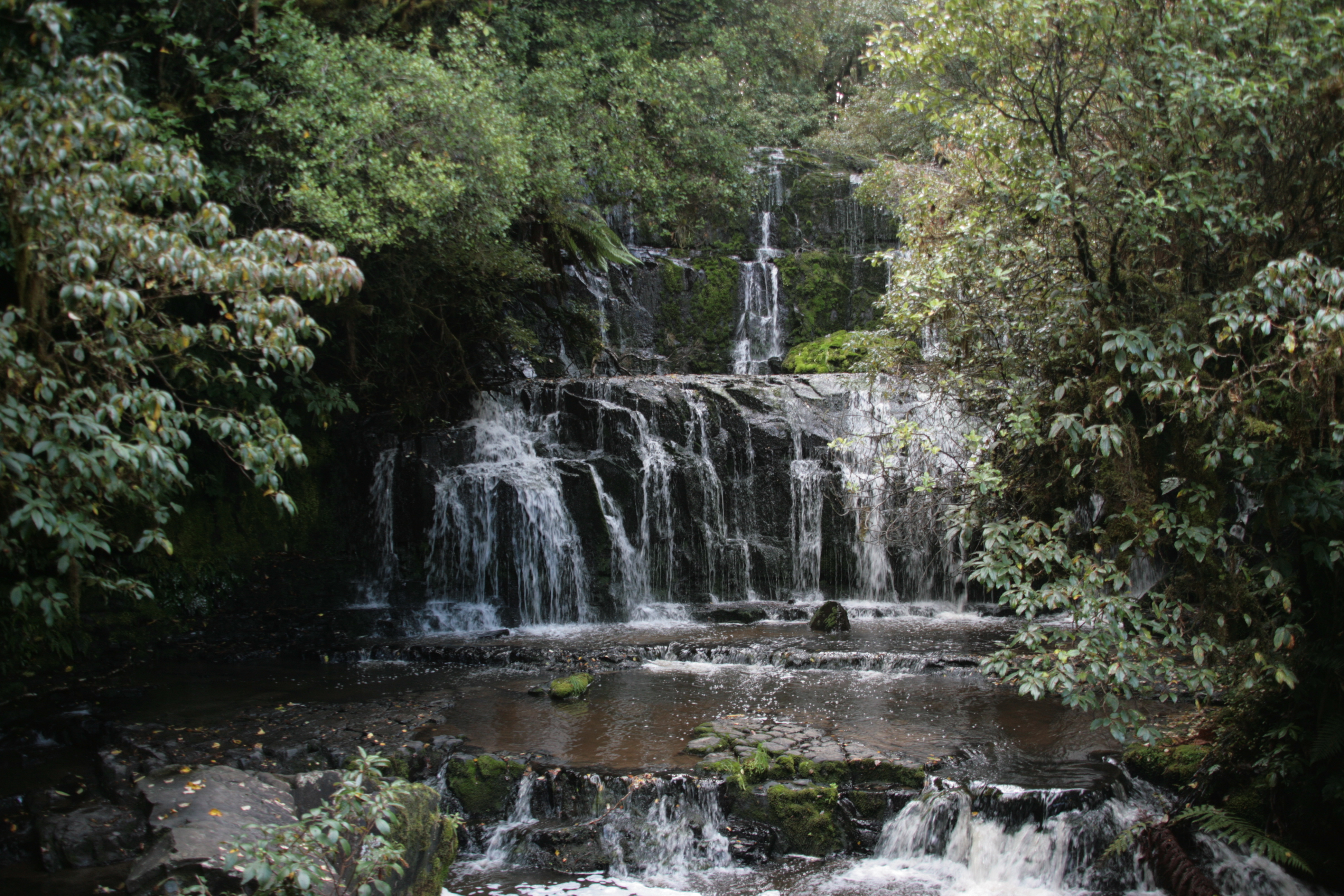
Three Steps of Stone
The falls cascade 20 metres in three distinct tiers, each ledge spreading the water wider before releasing it to the next. The effect is architectural, as though the rock were designed to display the water rather than merely channel it. The Purakaunui River is modest by New Zealand standards, not a large or powerful waterway, and the falls owe their appeal to proportion rather than scale. Each tier is broad enough to catch light differently depending on the hour and the season, and the surrounding bush presses close on both sides, framing the white water against a deep green backdrop of podocarp and silver beech. The forest here is not part of the Catlins Conservation Park, but it occupies a scenic reserve of five square kilometres, dense enough with native species that the ten-minute bush walk from the car park feels like an entry into a different climate. Birdsong replaces wind. The canopy closes overhead, filtering daylight to a green twilight. Then the sound of falling water reaches you before the falls themselves come into view.
A Waterfall in the Lowlands
What makes Purakaunui Falls unusual is its setting. The South Island's celebrated waterfalls, Milford Sound's Stirling Falls, the Sutherland Falls in Fiordland, are products of extreme alpine terrain, where rainfall and snowmelt drop from great heights through mountain valleys. Purakaunui Falls sits at low elevation, 17 kilometres southwest of the small town of Owaka and only 5 kilometres from where the river meets the Pacific Ocean. The surrounding landscape is gentle by South Island standards, rolling hills covered in native bush and farmland, crossed by gravel roads that branch off the Southern Scenic Route. The falls are a popular detour for travellers on that route, well signposted and accessible via a short side road off the main Owaka-Invercargill highway. A car park, toilets, and picnic area serve as the trailhead. Two viewing platforms offer perspectives from above and below: a wheelchair-accessible platform near the top, and a lower platform at the base reached by a set of steps that descend through the bush. From below, the full three-tiered geometry is visible, and in heavy rain the tiers merge into a single curtain of white water that transforms the orderly cascade into something wilder.
The Quiet Icon
Purakaunui Falls operates as a kind of ambassador for the Catlins, a region that lacks the name recognition of Fiordland or the Queenstown Lakes but contains some of the South Island's most intact native forest and wildest coastline. The falls appear in virtually every tourism brochure about the area, and photographs of the three-tiered cascade have been reproduced so widely that they function as a logo for the entire Catlins coast. Yet the experience of visiting remains intimate rather than grand. The bush walk is short, the crowds are small, and the sound of the falls fills a space that feels enclosed and private. Photographers have been coming here since at least 1908, when one of the earliest known images of the falls was captured and archived by the National Museum. The appeal has not changed in the century since: clean water, native forest, a cascade that falls in steps so regular they look deliberate. The Catlins has waterfalls that are taller and more remote, McLean Falls among them, but none that photograph as perfectly or welcome as accessibly as Purakaunui.
From the Air
Located at 46.52°S, 169.56°E in the Catlins district, 17 km southwest of Owaka. The falls are hidden within dense native bush and not directly visible from the air, but the Purakaunui River valley is identifiable as a forested drainage running roughly northeast to the coast. The river mouth, 5 km downstream, is visible where it enters the Pacific. The nearest airport is Invercargill (NZNV), approximately 100 km to the southwest. Dunedin Airport (NZDN) lies roughly 120 km to the northeast. The Southern Scenic Route highway is visible as a thin line through the rolling Catlins terrain. Best appreciated at low altitude (2,000-4,000 feet) where the dense bush canopy and river valleys become distinct from the surrounding farmland.