Purnululu National Park
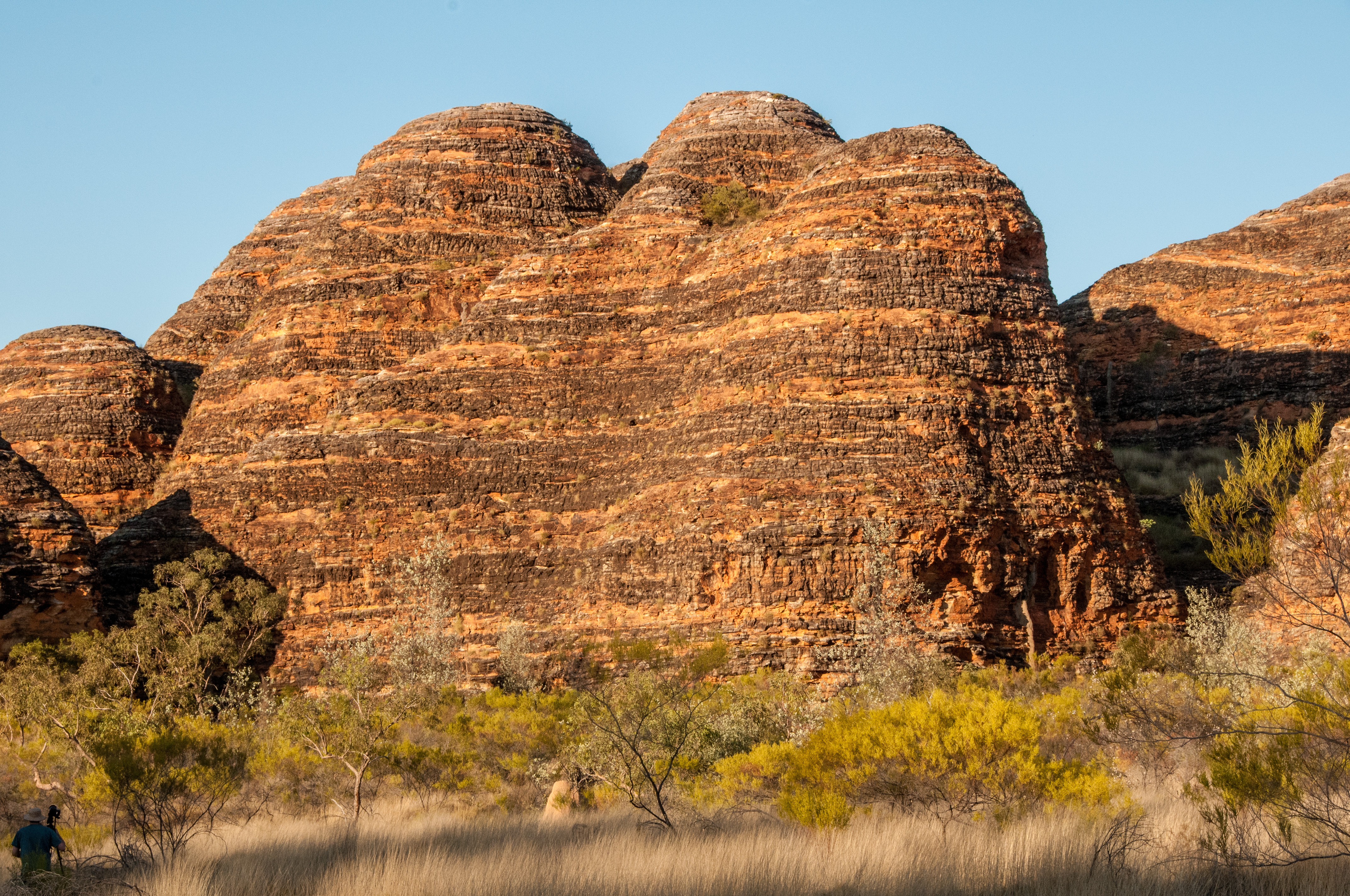
The Aboriginal name for the Bungle Bungle hills is Billingjal. It means "sand falling away" — which turns out to be a precise geological description. The surface of these beehive domes is so fragile that touching them with your hand will crumble them. Boots will erode them. The marked trails exist not as a formality but as a physical necessity: step off them, and you become part of the erosion that has been reshaping this landscape for 360 million years. The place does not care about visitors in the way that tourism infrastructure suggests. It predates the concept by an incomprehensible margin.
How Beehives Form in 360 Million Years
About 360 million years ago, a river flowed across a broad plain here, slowing and depositing mineral-laden sand and gravel. In dry years, the deposit was exposed to air and its iron minerals oxidised orange. In wet years, grey bacterial colonies coated the surface and excluded the air, creating the alternating bands. Australia was meanwhile colliding with tectonic plates to the north — a collision that continues today, building the volcanic ridge of Indonesia. These forces lifted the Kimberley into a plateau, compressing the river deposits beneath later materials.
Elsewhere in the world, similar Devonian sandstone formations were cemented by natural lime from ancient shellfish, creating rock hard enough to quarry. The Purnululu deposits lacked this cement. When erosion eventually carved through the plateau, the loose material fractured into the distinctive beehive formations. Their surfaces remain unfixed, wearing away and being rebuilt continuously. Outlying formations are almost gone; new ones are emerging at the rim of the plateau. You are watching geology at work.
In the Dreaming and on the Map
Purnululu derives from the Djaru Aboriginal term Bullmanlulu for this area. In the Dreaming of the Gija Aboriginal people, ancestral spirit-creatures fought for control of this land and its waterholes; the losers now huddle as the Bungle Bungles. The Gija have lived in relationship with this country for thousands of years. European surveyors passed through in the nineteenth century and went north, where the land was more amenable to grazing and the ports were accessible. The upper catchments of the Ord River were reconsidered in the 1950s for an irrigation scheme, but that project was built further downstream at Kununurra.
Purnululu entered the tourist imagination only in the 1980s. It became a national park in 1987 and a UNESCO World Heritage Site in 2003, recognised for its exceptional geology and the landscape's geological and biological values.
The Canyons of the North
Most visitors come for the domes in the southern part of the park, but the north is different — its surface riven by deep canyons walled in bright sandstone. Echidna Chasm is 180 metres deep and lined with Livistona fan palms (Livistona victoriae) that cling to walls and crevices at precarious angles. Some stand over 12 metres tall. Aim to be there between 11 in the morning and 1 in the afternoon, when the overhead sun penetrates the chasm and illuminates the rock faces red.
Mini Palms Gorge contains bonsai-sized palms that somehow survive the seasonal floods that scour the canyon floor. Cathedral Gorge opens from tight walls into a natural amphitheatre carved by an ancient river eddy. The Window, two kilometres from the car park, is a natural hole punched through the rock — dramatic at sunset when the light pours through.
Getting There, and Staying
The Bungle Bungles are not easy to reach. Spring Creek Track leaves the Great Northern Highway 250 kilometres south of Kununurra and runs 53 kilometres of unsealed, ungraded road that requires a high-clearance 4WD — not a rental SUV, but a proper vehicle with ground clearance and recovery gear. The drive to the visitor centre takes about three hours. It is another two hours to the domes. The park is reliably accessible in the dry season, May through October. Days average 30°C. Nights drop to around 15°C. In the wet season, the creeks flood and the park closes.
There is no air service to the park. Fixed-wing aircraft fly non-landing tours from Kununurra. Helicopter tours operate from Bellburn airstrip within the park. Booking accommodation is essential; arrive without a reservation and you may be turned back at the ranger station. The visitor centre is the only shop. The creek water is not potable. The park closes above 40°C. These are not inconveniences — they are the conditions of a place that has been here for 360 million years and will be here considerably longer.
From the Air
Purnululu National Park is at 17.45°S, 128.55°E in the far northeast Kimberley. Bellburn airstrip (within the park) accommodates helicopters and light aircraft but has no fuel. Kununurra (YKUN) is the nearest town with full services, 300 km north. From the air at 3,000–6,000 feet, the Bungle Bungle domes are unmistakable — a landscape of orange-and-grey striped beehives stretching across the plateau. The park also contains Wolfe Creek Crater (7 km in diameter, formed 300,000 years ago) to the south, visible from altitude. Spring Creek Track is faintly traceable from the air as it winds from the highway into the range.