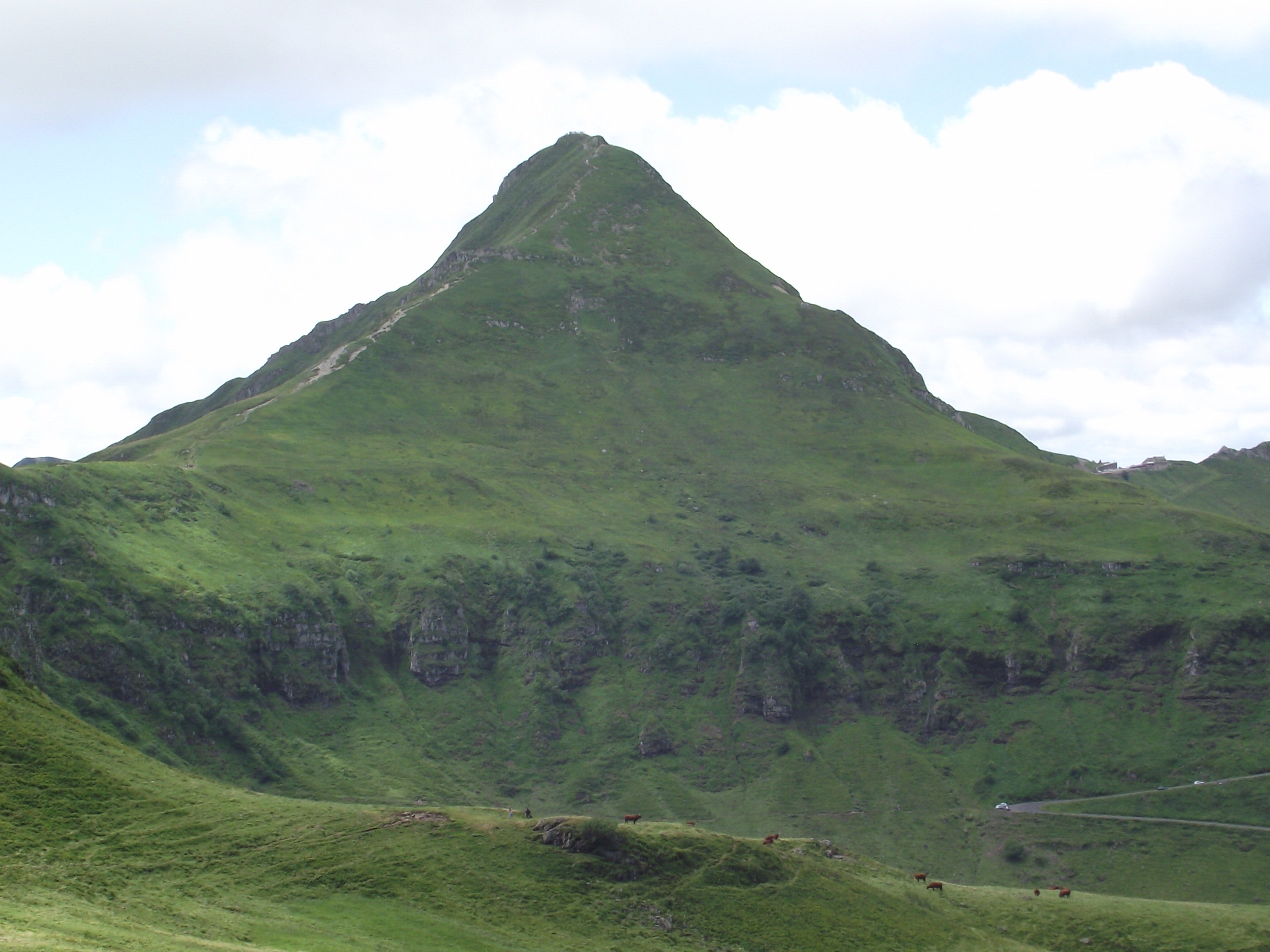
Puy Mary
Seven valleys radiate from Puy Mary like the spokes of a wheel, each carved by glaciers that spent millennia sculpting a volcano into something more elegant than eruption alone could have produced. At 1,783 meters, this pyramidal peak in the Cantal mountains is not France's tallest, but it may be its most perfectly shaped -- the geometric result of 6.5 million years of lava accumulation followed by ice-age erosion that stripped away everything soft and left a trachyte spine standing clean against the sky of the Massif Central.
Born of Lava, Carved by Ice
Puy Mary is the remnant of what was once an enormous stratovolcano, part of the Cantal volcanic complex -- the largest such structure in Europe, originally spanning roughly 70 kilometers in diameter. The mountain formed through the accumulation of trachyte, a viscous lava that built up in thick, resistant layers. When the Quaternary glaciations arrived, ice sheets carved the radiating valley pattern that gives the summit its distinctive star shape when viewed from above. The Pas de Peyrol, at 1,589 meters, serves as the gateway for hikers approaching the summit. It holds the distinction of being the highest road pass in the entire Massif Central, a plateau that covers roughly a sixth of France. From this pass, the final ascent follows a well-worn path to the peak, where on clear days the view encompasses the full sweep of the Cantal range and the volcanic heritage that built it.
Where the Atlantic Breaks
Puy Mary is the first significant mountain that oceanic weather systems encounter after crossing the plains from the Atlantic. This makes it one of the wettest places in France. Clouds pile against its western flanks, releasing moisture that feeds the streams coursing down all seven valleys. In winter, snow buries the summit and the Pas de Peyrol road closes, isolating the peak in a white silence. The abundant precipitation creates conditions that would seem more at home in Scotland or Norway than in south-central France, supporting a landscape of high-altitude grasslands, bogs, and rocky outcrops that contrasts sharply with the agricultural lowlands that surround the Cantal massif on every side.
A Garden at Altitude
The subalpine zone of the Cantal mountains supports 550 plant species, 130 of which are considered fragile. Among them are true rarities: Saxifraga oppositifolia, a purple-flowered alpine saxifrage typically found in Arctic environments; Saxifraga androsacea, clinging to limestone crevices; and the verticillate lousewort, Pedicularis verticillata. Most remarkable is Saxifraga exarata subspecies lamottei, an endemic plant found only in the Cantal and the neighboring Monts Dore -- it exists nowhere else on Earth. Puy Mary serves as one of the best locations to observe this high-altitude flora, its slopes offering a compressed vertical transect through ecological zones that elsewhere would require hundreds of kilometers of latitude to traverse. The mountain's classification as a Grand Site de France reflects both its geological significance and the ecological wealth it supports.
Half a Million Pilgrims
Nearly 500,000 visitors come to Puy Mary each year, drawn by the accessibility of a genuine alpine experience in the heart of France. The hike from the Pas de Peyrol to the summit is short but steep, rewarding walkers with a panorama that unfolds in every direction -- the seven glacial valleys stretching away like fingers, each with its own character, its own stream, its own shade of green or grey depending on season and weather. The mountain's volcanic origins are legible in the landscape: the dark trachyte rock, the radial symmetry of the ridgelines, the steep-walled cirques that betray the glaciers' work. For a summit that predates human presence in Europe by millions of years, Puy Mary wears its age lightly, its pyramidal profile as sharp and clean as the day the last glacier retreated.
From the Air
Located at 45.11°N, 2.68°E in the Cantal department of the Massif Central. The pyramidal peak is a prominent terrain feature surrounded by seven radiating glacial valleys, easily identifiable from altitude. Maintain safe altitude in mountain weather conditions -- orographic clouds frequently form on the western flanks. Nearest airport is Aurillac (LFLW), approximately 25 km southwest. Best viewed at 5,000-8,000 ft AGL in clear conditions. Be alert for turbulence from mountain wave effects.