Puy Pariou
From the right angle, it looks like Vesuvius. The comparison is not casual — geologists have long noted the resemblance between Puy Pariou and its famous Italian counterpart, both featuring a younger cone sitting atop the remnants of an older one, a formation called a somma volcano. But Puy Pariou is not in the Mediterranean. It rises 1,209 meters above sea level in the heart of France, just 10 kilometers west of Clermont-Ferrand, one link in the Chaîne des Puys volcanic chain that marches across the Massif Central like a textbook illustration of how eruptions build landscapes.
A Crater Inside a Crater
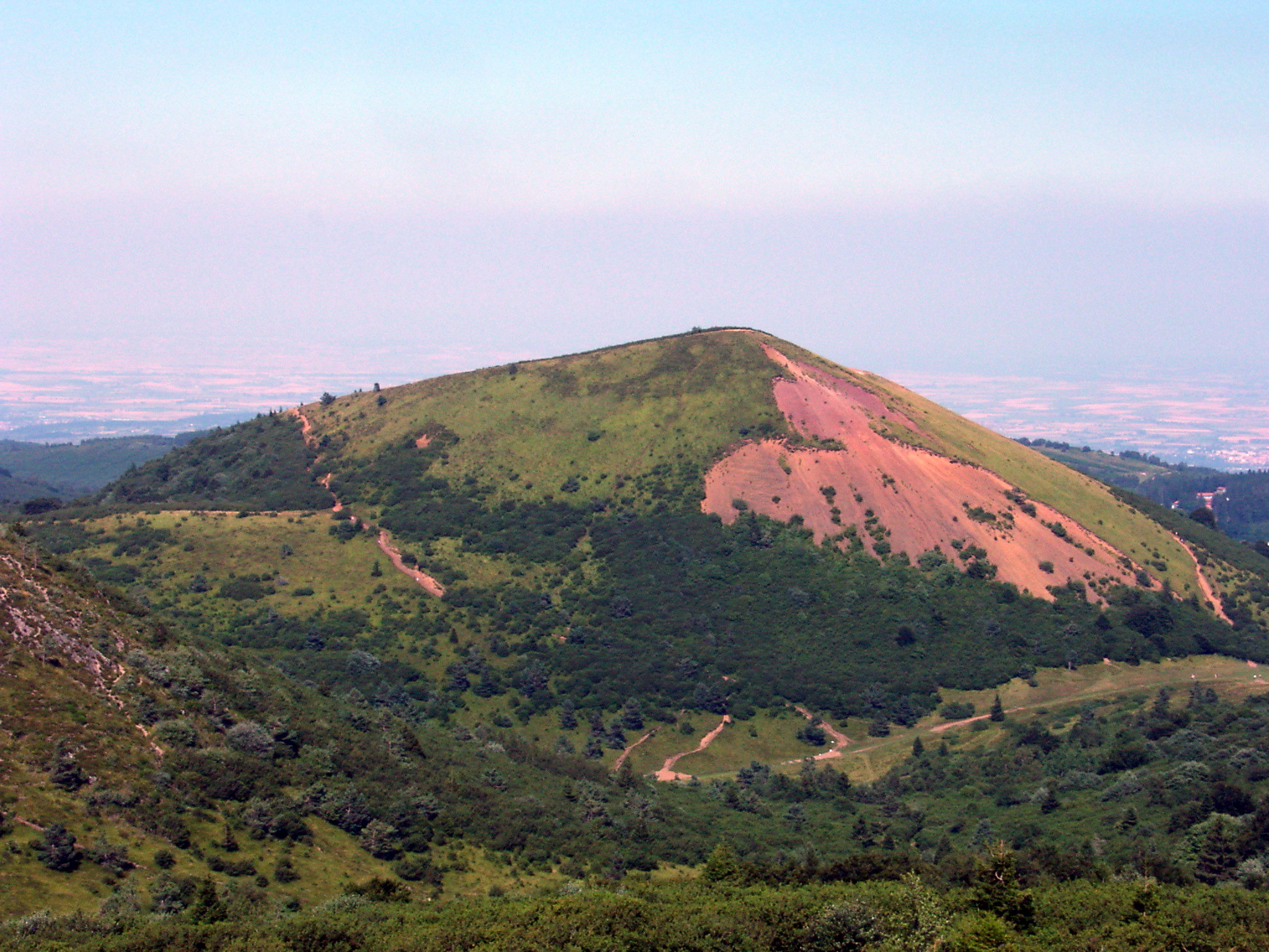
Puy Pariou's most striking feature is its double crater. The inner crater, called 'new Pariou,' is almost perfectly circular: 200 meters in diameter and 90 meters deep, a geometry so clean it looks engineered. It sits nested within the remnants of 'old Pariou,' the earlier cone, though the two are not aligned on the same axis. From the west and north, the ancient rim of old Pariou and its associated tuff ring are still visible, but from the south and east, the newer cone has buried its predecessor entirely. The summit stands 250 meters above the crystalline basement rock that forms the surrounding plain, and the ground is sparse — deciduous trees, junipers, and a thin, short grass clinging to volcanic soil that has never been fertile.
Three Eruptions, Three Lava Flows
Puy Pariou's eruptive history unfolded in three distinct phases. First came old Pariou, a strombolian cone that ejected trachytic products mixed with rubble from the crystalline basement. Its magma shifted to trachybasalt and sent a lava flow southwest for nearly 2 kilometers, reaching the area now occupied by the village of Orcines. A more explosive episode followed, when a trachyandesitic tuff ring nearly buried the old cone, spreading ash at least as far as Clermont-Ferrand. Then the new Pariou erupted, slightly off-center to the south, its trachyandesite flow covering the earlier deposits. At Orcines, this second flow divided into two branches: one reached Nohanent, and the other traveled 8 kilometers to the Chamalières area on the outskirts of Clermont-Ferrand. Radiocarbon dating of wooden pieces trapped in the flow places this eruption at approximately 8,580 years ago.
The Vanished Lava Lake
Between the bottom of the new Pariou cone and the inner walls of the tuff ring, a lava lake briefly formed. The molten rock punched a 200-meter breach through the northeastern border of the ring, then drained, leaving behind a small trachyandesitic flow. Blocked to the north by the Puy des Goules, this flow turned east and finally stopped at a location still called Fontaine du Berger — Shepherd's Fountain. It is a reminder that these volcanoes, while dormant, are young in geological terms. The Chaîne des Puys contains roughly 80 volcanoes, and their UNESCO World Heritage designation reflects not just their beauty but their scientific value as a near-complete record of volcanic processes.
A Geology Lesson in Living Rock
The rocks of Puy Pariou read like a mineralogy catalog. Old Pariou produced black trachyte and trachybasalt containing augite, bytownite, labradorite, and olivine crystals. The tuff ring contributed dark trachyandesite with andesine and hornblende crystals suspended in light brown volcanic glass. New Pariou's grey-blue trachyandesite holds labradorite and hornblende trapped in a glassy matrix of feldspar, pyroxene, and olivine. The lava was exceptionally gas-rich, as evidenced by countless elongated bubbles frozen in the direction of flow. Standing on the crater rim with the Puy de Dôme looming just 1.5 kilometers to the south, the scale of volcanic activity in this small patch of central France becomes vivid: this was not one eruption but an entire volcanic province, and it shaped everything from the soil to the stone buildings of nearby Clermont-Ferrand.
From the Air
Located at 45.80°N, 2.97°E in the Chaîne des Puys, approximately 10 km west of Clermont-Ferrand. The double crater is clearly visible from the air, with the nearly perfect circle of the inner crater being especially distinctive. The Puy de Dôme (1,465m) lies 1.5 km to the south. Clermont-Ferrand Auvergne Airport (LFLC) is the nearest field. The entire Chaîne des Puys volcanic chain is a spectacular aerial feature. Recommend viewing at 5,000-8,000 ft AGL. Be aware of terrain elevation around 1,200m in this area.