Puye Cliff Dwellings
In the Tewa language, pu means cottontail rabbits and ye means to assemble. The name Puye, then, conjures an image of rabbits gathering -- a place of abundance on a volcanic cliff face in northern New Mexico where, beginning in the late 1200s, hundreds of people carved homes directly into the soft tuff rock. For roughly three centuries, the Puye Cliff Dwellings formed one of the largest prehistoric settlements on the Pajarito Plateau, a complex multi-level community of cave rooms, cliff houses, and a full puebloan village on the mesa top above. The people who built it are not lost to history. The inhabitants of Santa Clara Pueblo, just a few miles to the east, claim direct descent from Puye's residents.
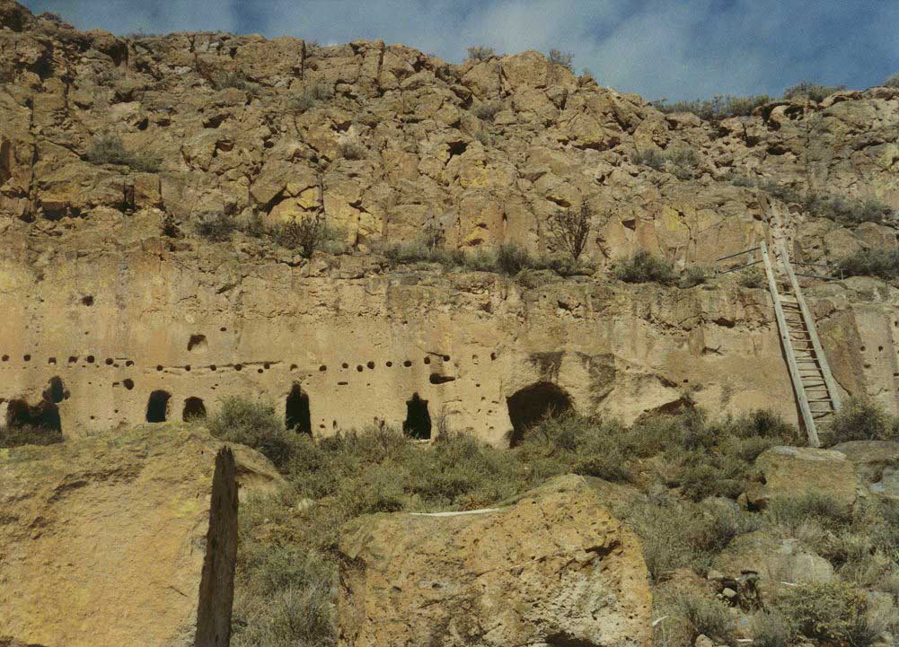
A City in the Cliffs
The Puye complex is an architectural marvel spread across two levels of cliff dwellings, surface rooms, and cave dwellings carved into the mesa's edge. Twelve stairways and ladders cut directly into the rock connect the levels, worn smooth by centuries of hands and feet. One tier of cliff dwellings stretches for a considerable distance along the cliff face, with a second tier running parallel above it. On the mesa top sit cave dwellings dating to the Pueblo II Era, around which a multi-storied puebloan village eventually rose. The south portion alone contained 173 ground-floor rooms, and the total number -- including the northern side and upper levels -- would have been substantially larger. A large central plaza anchored the community, a gathering space that served as the heart of village life for generations.
Three Centuries of Shelter
The settlement took shape in the late 1200s or early 1300s, during a period when Ancestral Pueblo communities across the Southwest were consolidating into larger, more defensible villages. Puye's cliff-side location offered natural protection and access to the resources of both the mesa top and the canyon below. The community endured for roughly three hundred years, a testament to the ingenuity of its builders and the productivity of the surrounding landscape. But around 1580, after the end of the Pueblo IV Era, a prolonged drought finally broke the community's ability to sustain itself at this elevation. The residents migrated east toward the Rio Grande valley, where water was more reliable. They settled at what is now Santa Clara Pueblo, carrying with them the knowledge, traditions, and cultural memory of their cliff-side home.
Fire and Recovery
In May 2000, a planned burn of trees in nearby Bandelier National Monument escaped control and became the Cerro Grande Fire, one of the most destructive wildfires in New Mexico history. The blaze destroyed some 250 homes in Los Alamos and devastated Santa Clara Canyon, scorching the landscape around the cliff dwellings that had survived intact for seven centuries. The fire forced the closure of the Puye site and left the Santa Clara Pueblo community facing the dual challenge of rebuilding their modern homes and protecting their ancestral heritage. The site has since been reopened to the public under the management of Santa Clara Pueblo. Visitors check in at the Puye Cliffs Welcome Center and can schedule guided tours led by tribal members who share the history of their ancestors' remarkable home.
Living Heritage
Puye is not a ruin in the way that many archaeological sites are. It is an ancestral home, actively claimed and cared for by the people who descended from its builders. Santa Clara Pueblo manages access to the site, and the tours offered by tribal members provide a perspective that no museum placard can match. The National Park Service recognized Puye's significance by designating it a National Historic Landmark in 1966. The site also found its way into popular culture through the 1952 film The Atomic City, which used the dramatic cliff setting as a backdrop. But Puye's real power lies in its continuity. The stairways carved into the cliff, the plaza where community gathered, the rooms where families slept -- these spaces connect a living people to a place they have never truly left, even after four centuries away.
From the Air
Located at 35.98N, 106.23W on the Pajarito Plateau in Santa Clara Canyon, on Santa Clara Pueblo Reservation land near Espanola, New Mexico. The cliff dwellings are carved into a south-facing volcanic tuff escarpment at approximately 6,800 feet elevation. From the air, look for the distinctive mesa edge with visible cliff face along Santa Clara Canyon. Los Alamos County Airport (KLAM) lies roughly 10 miles to the south-southwest. Bandelier National Monument is nearby to the south. Be aware of variable mountain weather and restricted airspace associated with Los Alamos National Laboratory operations.