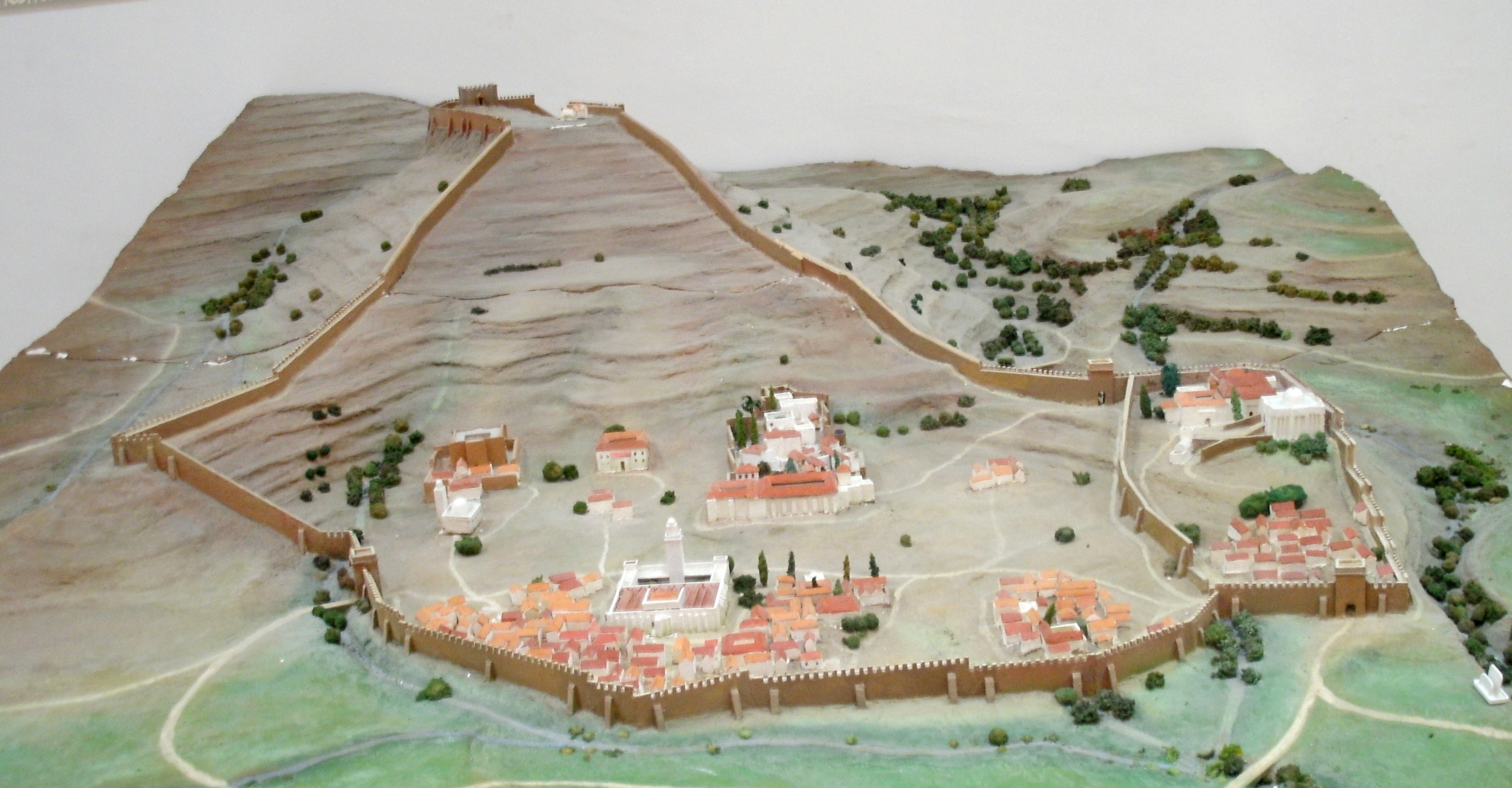
Qal'at Bani Hammad
Two hundred and twenty-five kilometers southeast of Algiers, at 1,418 meters in the Hodna Mountains, sit the ruins of a city that once attracted poets, sages, and theologians from across the medieval Maghreb. Qal'at Bani Hammad was the first capital of the Hammadid dynasty, a fortified palatine city whose palaces contained what may be the earliest muqarnas vault in the Islamic world. UNESCO inscribed it as a World Heritage Site in 1980, calling it "an authentic picture of a fortified Muslim city." Most of it remains unexcavated. What has been uncovered suggests a civilization of extraordinary architectural ambition.
A Capital Built from Rebellion
The Hammadids broke away from the Zirid dynasty in the early 11th century, and Hammad ibn Buluggin chose this mountain site for his new capital with strategic precision. The Hodna Mountains provided elevation, natural defenses, and abundant water from surrounding springs. The city grew rapidly, following the traditional Islamic urban plan: congregational mosque first, then administrative buildings, then residences. Ibn Khaldun recorded that the Qala attracted a constant stream of travelers drawn by its wealth of resources for those interested in sciences, commerce, and arts. The Hammadid architecture was so distinctive that it even influenced Norman builders -- a remarkable cultural transmission across the Mediterranean.
Palace of Water, Palace of Peace
Multiple palaces dotted the fortified city. The upper palace consisted of three buildings arranged around an irregularly shaped forecourt: a private apartment, a domed hall, and an entrance wing. The Qasr al-Salam -- Palace of Peace -- likely served as the ruler's family residence, and its architecture summarized the distinctive Hammadid style: forecourts, audience halls, and private apartments surrounded by T-shaped pillared porticos. The Qasr al-Manar followed a similar plan. But the most intriguing discovery came from the Qasr al-Salam, where excavators found fragments of a muqarnas semi-dome. According to the French archaeologist Lucien Golvin, these are the oldest documented remains of a true muqarnas vault anywhere in the Islamic world, though other scholars have debated this dating.
The Minaret and the Giralda
The most visible surviving structure is the minaret of the Great Mosque, standing 82 feet high. Its resemblance to Seville's Giralda is not coincidental -- the Hammadid decorative scheme of vertically arranged ornamental registers was a pioneering innovation that traveled westward through the Almohad dynasty to appear on some of the most famous minarets in the Islamic West. Pieces of the city's exquisite decorative work -- stucco fragments, mosaic panels in faience -- have made their way to museums around the world, including the Louvre. The architecture of the Qal'at is now understood as a key link in the chain of Western Islamic art, a documented precursor to developments that would unfold across North Africa and the Iberian Peninsula in the 12th century.
Buried Ambitions
The city's decline came with the arrival of the Banu Hilal, Arab tribes whose settlement in the region disrupted the Hammadid political order. The capital was eventually abandoned, and its buildings crumbled back into the mountain landscape. General de Beylie's excavation campaign in 1908 was the first systematic investigation, partially uncovering the Palace of the Lake and the Great Mosque. Algerian archaeologist Rachid Bourouiba continued the work from 1964 to 1972. A UNESCO preservation plan ran from 1976 to 1982, and an Algerian-Polish restoration mission followed in 1987. But most of the site remains unexplored, its palaces waiting beneath the soil of the Hodna Mountains. What has already emerged suggests that full excavation would rewrite chapters of Islamic art history.
From the Air
Located at 35.81N, 4.79E in the Hodna Mountains, M'sila Province, Algeria, at 1,418 meters elevation. The ruins are spread across a mountain plateau near the town of Maadid, approximately 225 km southeast of Algiers. The minaret is the most prominent vertical feature. Best viewed at 3,000-5,000 feet AGL. Nearest airport: DABC (Mohamed Boudiaf Airport, M'sila), approximately 60 km southwest. The site is identifiable as a cleared area with scattered ruins on the mountainside.