Qalhat
Three of history's most famous travelers visited the same city, centuries apart, and each recorded its name differently. Marco Polo called it Calatu. Ibn Battuta simply described what he saw. Zheng He's crew transliterated it into Chinese characters. Today, almost nothing remains of Qalhat except a roofless mausoleum, sixty acres of crumbled walls, and the kind of silence that settles over places the world has moved past.
Crossroads of the Known World
Qalhat sits on Oman's northeastern coast, about twenty kilometers north of Sur, where the Hajar Mountains descend toward the Gulf of Oman. In its prime, the city served as the second capital of the Kingdom of Ormus and a critical node in the Indian Ocean trade network. Ships from Persia, India, and China docked in its harbor. Artifacts excavated from the site include pottery and goods from across Asia, evidence of a commercial reach that spanned thousands of miles. Surrounded by fortified walls, the city contained houses, shops, and the infrastructure of a prosperous port. By the thirteenth century, when Marco Polo passed through, Qalhat was a place worth noting on any map.
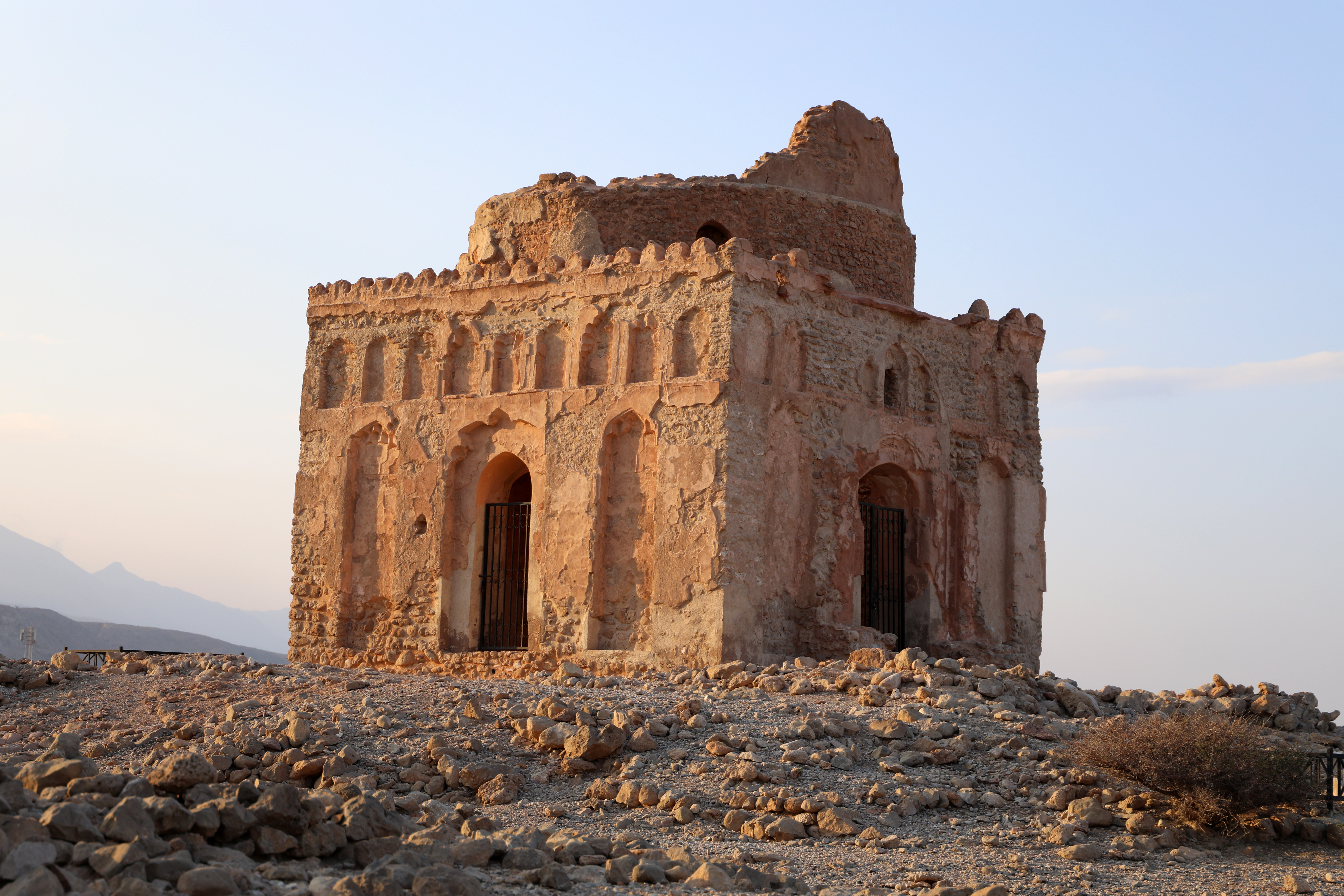
The Tomb That Outlasted the City
The most prominent surviving structure is the mausoleum of Bibi Maryam, a woman whose identity remains debated. Some historical sources describe her as an elderly benefactress who funded the construction of a mosque. Others suggest she was a ruler of Qalhat during the reign of the Hormuz king Qutb al-Din. Her title, Bibi, translates roughly as 'the free woman.' The tomb's dome has long since collapsed, but the walls still stand, decorated with fragments of tilework that hint at the sophistication of Qalhat's architecture. An underground passage at the entrance leads to corridors beneath the structure, their purpose unclear.
Decline and Rediscovery
Qalhat's fall came in stages. A fourteenth-century earthquake damaged the city. Trade gradually shifted to Muscat, which offered a more sheltered harbor. When Afonso de Albuquerque captured Qalhat for the Portuguese Empire in 1507, the city was already diminished. The Portuguese held it until their expulsion in the late sixteenth century, but by then there was little left to hold. Over the following centuries, the ruins dissolved into piles of stone stretching along the shoreline. Houses collapsed on their foundations. Defensive walls crumbled. The site was added to UNESCO's World Heritage Tentative List in 1988 and later inscribed as a full World Heritage Site, recognizing the archaeological importance of what once connected East Africa, Arabia, India, and China through trade.
Ancient Stones, Modern Industry
The contrast at Qalhat today is striking. Adjacent to the ancient ruins, the Qalhat LNG Terminal processes liquefied natural gas for export. Oman's modern economy operates within sight of its medieval past. The juxtaposition is not ironic so much as continuous: Qalhat has always been about trade, about the movement of valuable commodities across water. The goods have changed from spices and silk to hydrocarbons, but the geography that made this stretch of coastline strategic remains unchanged. The Gulf of Oman still funnels global commerce through a narrow corridor, and Qalhat still sits at its edge, a reminder that prosperity and ruin often share the same address.
From the Air
Coordinates: 22.70N, 59.37E, on Oman's northeastern coast about 20 km north of Sur. Best viewed at 5,000-8,000 ft to see the ruins along the shoreline and the adjacent LNG terminal. The Hajar Mountains provide dramatic backdrop to the west. Nearest airport is Sur (not ICAO coded); Muscat International (OOMS) is approximately 200 km northwest. Typically clear and dry.