Quadra Island
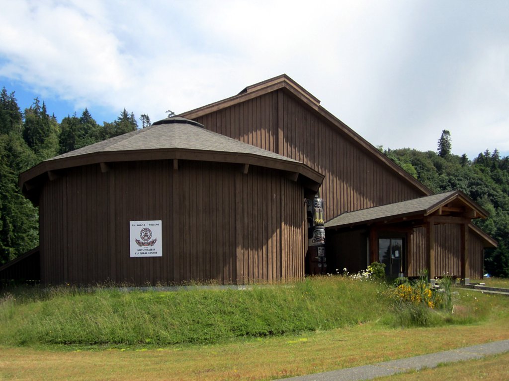
In 1922, the Canadian government arrested members of the We Wai Kai people at Cape Mudge for the crime of holding a potlatch -- a ceremonial gathering that had been the social and spiritual core of Kwakwaka'wakw culture for centuries. The masks and regalia seized in the raids were shipped to museums in Ottawa and New York. It took 50 years for any of it to come back. Today, the Nuyumbalees Cultural Centre at Cape Mudge Village holds the returned Sacred Potlatch Collection, and the Centre continues tracking down artifacts scattered across institutions worldwide. Quadra Island's history is full of outsiders arriving and claiming things. This is the story of what endured.
Two Empires, One Island
Quadra Island bears the name of Juan Francisco de la Bodega y Quadra, the Peruvian-born Spanish navigator who explored and claimed the Vancouver Island area for the Spanish Empire in the late 18th century. Spain and Britain nearly went to war over these islands in the 1790s, in what became known as the Nootka Crisis. Three successive Nootka Conventions -- in 1790, 1793, and 1794 -- gradually defused the standoff, and the final treaty saw Spain dismantle its fort on Vancouver Island and withdraw, with both powers agreeing to share trade and shipping rights rather than establish permanent settlements. The 1846 Oregon Treaty settled the question of the international border, placing Quadra Island firmly in British territory. But the island's name preserves the Spanish claim, a linguistic reminder of the empire that left first.
The People Who Stayed
When Captain George Vancouver visited in 1792, he described a Coast Salish village at Cape Mudge with longhouses, boats, and a population of roughly 300 people. Over the following decades, the We Wai Kai -- a people with roots among the Kwakwaka'wakw to the north -- took control of the island through a combination of warfare and intermarriage, displacing the Salish inhabitants. The We Wai Kai fished for salmon year-round, and the fishing fleet they built at Cape Mudge in the 1890s is still active today. But the Canadian government barred them from the mechanized fishing fleet until 1926, prohibited them from buying alcohol, and outlawed their potlatches. The 1922 confiscation of ceremonial regalia was the most visible wound. The return of those artifacts, beginning in the 1970s, and the opening of the Nuyumbalees Cultural Centre in 1979, marked the beginning of a cultural reclamation that continues today.
Copper, Fire, and Slow Recovery
European settlement on Quadra brought the usual frontier economy: logging camps, mills, a hotel, two post offices, a school, and a mission -- all in place by 1904. The Lucky Jim copper and gold mine opened that same year but was destroyed by fire in 1941. In fact, severe fires repeatedly devastated the island, crippling the local economy well into the 1930s. Recovery was gradual. A passenger ferry began service in 1949, and a vehicle ferry followed in 1960, finally connecting Quadra's roughly 4,000 residents reliably to Campbell River and Vancouver Island. Today the island's economy runs on fishing, logging, tourism, and the arts -- a mix that reflects both its resource-extraction past and its reinvention as a destination.
The Largest of the Discovery Islands
At 310 square kilometres, Quadra Island is the largest of the Discovery Islands and the second-largest island in the Salish Sea after Whidbey Island in Washington State. It stretches 35 kilometres from north to south, narrowing to less than two kilometres at its southern peninsula before widening to 15 kilometres at its broadest point. Discovery Passage separates it from Vancouver Island to the west; Sutil Channel and Read Island stand between it and Cortes Island to the east. Main Lake Provincial Park occupies the northern interior, while Rebecca Spit Marine Provincial Park extends into the sea from the eastern shore near Heriot Bay. The island's soils are poor -- coarse, acidic podzols that resist agriculture -- yet residents maintain thriving home gardens, and the island hosts a well-attended Garden Club and a biannual Quilt and Garden Tour.
A Ten-Minute Crossing
The BC Ferry terminal at Quathiaski Cove makes 18 round trips daily to Campbell River, a ten-minute crossing that is Quadra's lifeline. The island has its own services -- a medical clinic, pharmacy, library, grocery store, RCMP detachment, and hardware store -- but Campbell River remains the hub for hospitals, high schools, and major shopping. Students in grades 6 through 12 commute by ferry every school day. Despite this dependence, Quadra maintains a distinct identity. The We Wai Kai operate the Tsa-Kwa-Luten Lodge and RV Park, one of the island's major tourism businesses. Quathiaski Cove serves as the commercial hub, while Heriot Bay, on the eastern shore, offers a quieter, more picturesque alternative and the ferry connection onward to Cortes Island.
From the Air
Quadra Island is centered at approximately 50.181N, 125.253W, clearly visible from altitude as the large island east of Campbell River across Discovery Passage. The island's distinctive narrow southern peninsula and wider northern half are identifiable. Cape Mudge, at the southern tip, is marked by a lighthouse. Campbell River Airport (YBL/CYBL) lies on the Vancouver Island shore approximately 5 nm west. Best viewed at 3,000-5,000 feet AGL to appreciate the island's full extent and its relationship to Discovery Passage, Cortes Island, and the Discovery Islands archipelago.