Queen Charlotte Track
The ridgeline is barely wide enough for the trail. To the left, Queen Charlotte Sound spreads in deep blue folds toward Cook Strait. To the right, Kenepuru Sound mirrors the pattern in greener, quieter water. For 70 kilometers, the Queen Charlotte Track walks this line between two drowned valleys, climbing through native bush to 470 meters before descending to bays where the only access is by boat. It is one of New Zealand's most popular tramping tracks, and one of the few where you can have your pack ferried ahead by water taxi while you walk unencumbered along the spine of the Marlborough Sounds.
From Ship Cove to Anakiwa
The track begins at Meretoto / Ship Cove, the bay where Captain James Cook anchored during his voyages to the Pacific, and ends 70 kilometers south at Anakiwa. Most trampers walk it in three to five days, though mountain bikers can cover the distance in about 13 hours, typically split over two days. The route follows clay trails through native bush, crossing bridges over every major stream, and passes both Department of Conservation campsites and private lodges. Boat services from Picton provide access to multiple points along the track, making day walks practical for those who prefer to tackle a single section. Resolution Bay, Endeavour Inlet, Camp Bay, and Mistletoe Bay all serve as embarkation points.
Two Sounds, One Ridge
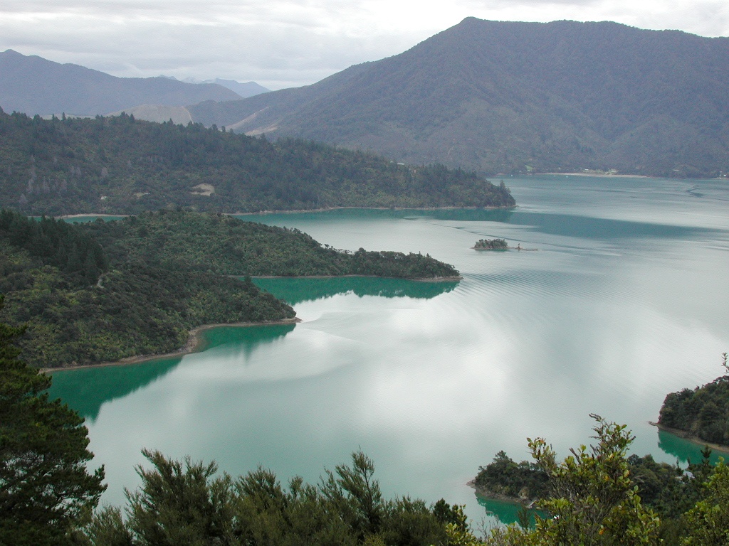
What makes the Queen Charlotte Track distinctive among New Zealand's great walks is its geography. The trail follows a narrow ridge between two parallel sounds, which means the views alternate constantly. One moment you look north across Queen Charlotte Sound's island-studded waters toward Cook Strait; the next, you drop to a saddle and Kenepuru Sound opens to the south, more sheltered and intimate. The highest point reaches 470 meters, enough elevation to see both waterways simultaneously on clear days. The native bush transitions as you climb, from coastal species near the bays to beech forest along the ridgeline, and birdsong fills the canopy throughout.
Wheels on the Ridge
Since 2013, the Queen Charlotte Track has doubled as one of New Zealand's Great Rides, part of the national cycle trail network. Mountain bikers share the track with walkers for most of its length, though the section from Meretoto / Ship Cove to Kenepuru Saddle closes to bikes from December through February to protect the trail surface and reduce conflict during peak summer tramping season. The rest of the year, riders tackle the same ridgeline route, navigating clay surfaces that can turn slick after rain. The combination of elevation changes, technical terrain, and coastal scenery has made it one of the country's most sought-after backcountry rides.
Private Land, Shared Trail
Unlike many of New Zealand's tramping tracks, the Queen Charlotte Track crosses significant stretches of private land. Between Kenepuru Saddle and just past Mistletoe Bay, walkers and bikers must carry a pass issued by the Queen Charlotte Track Land Cooperative. The fees fund track maintenance and ensure continued public access across private holdings, an arrangement that reflects the collaborative relationship between landowners and the Department of Conservation. Side tracks branch off to hidden bays like Miriту Bay and Lochmara Bay, where the only accommodation is accessible by water. August 2022 storms damaged road access to several points along the track, making boat transfers even more essential.
The Pace of the Sounds
The Queen Charlotte Track teaches a particular rhythm. You rise early, walk a ridgeline section in the morning light, descend to a bay for lunch, and wait for the water taxi to carry your pack to the next stop. Or you carry everything yourself and camp at a DOC site where the only sounds are bellbirds and the lap of water against a gravel shore. Either way, the track strips away the urgency of the road. There is no cell service on much of the route, no shortcut between the sounds. The only way through is on foot or pedal, one ridge at a time, with the water always visible on both sides and the bush closing overhead like a green tunnel.
From the Air
The Queen Charlotte Track runs along the ridgeline between Queen Charlotte Sound and Kenepuru Sound at approximately 41.22S, 173.97E. From altitude, the track is not directly visible, but the narrow peninsula between the two sounds is unmistakable. The northern terminus at Meretoto / Ship Cove sits near the entrance to Queen Charlotte Sound. Anakiwa at the southern end lies near the head of the sound. Nearest airport is Picton (NZPN) with Sounds Air services. Blenheim/Woodbourne (NZWB) is the nearest major airfield. Best viewed at 5,000-8,000 ft to appreciate the parallel sound geography.