Queen Elizabeth National Park
In the Ishasha sector of Queen Elizabeth National Park, lions do something that confounds biologists: they climb trees. Not occasionally, not as juveniles testing their limits, but routinely -- entire prides draped across the branches of fig and acacia trees like oversized house cats, limbs dangling, tails swaying in the equatorial breeze. This is one of only two places on Earth where lions exhibit this behavior, and nobody is entirely certain why. The leading theories involve escaping tsetse flies and ground-level heat, but the lions themselves seem unbothered by the mystery. They simply climb.
Where Two Lakes Breathe Through One Channel
Queen Elizabeth National Park covers nearly 1,978 square kilometers of western Uganda, stretching between Lake Edward to the south and Lake George to the north. Connecting them is the Kazinga Channel, a 32-kilometer natural waterway that serves as the park's arterial pulse. The channel holds one of the highest concentrations of hippos in Africa -- an estimated 5,000 individuals packed into its waters, surfacing and submerging in a slow, grunting rhythm. Boat safaris along the channel pass within meters of these pods, along with Nile crocodiles basking on sandbars and African buffalo drinking at the water's edge. On a clear day, the mist-shrouded Rwenzori Mountains -- the fabled Mountains of the Moon -- rise to the northwest, their glaciated peaks an improbable backdrop to the savanna below.
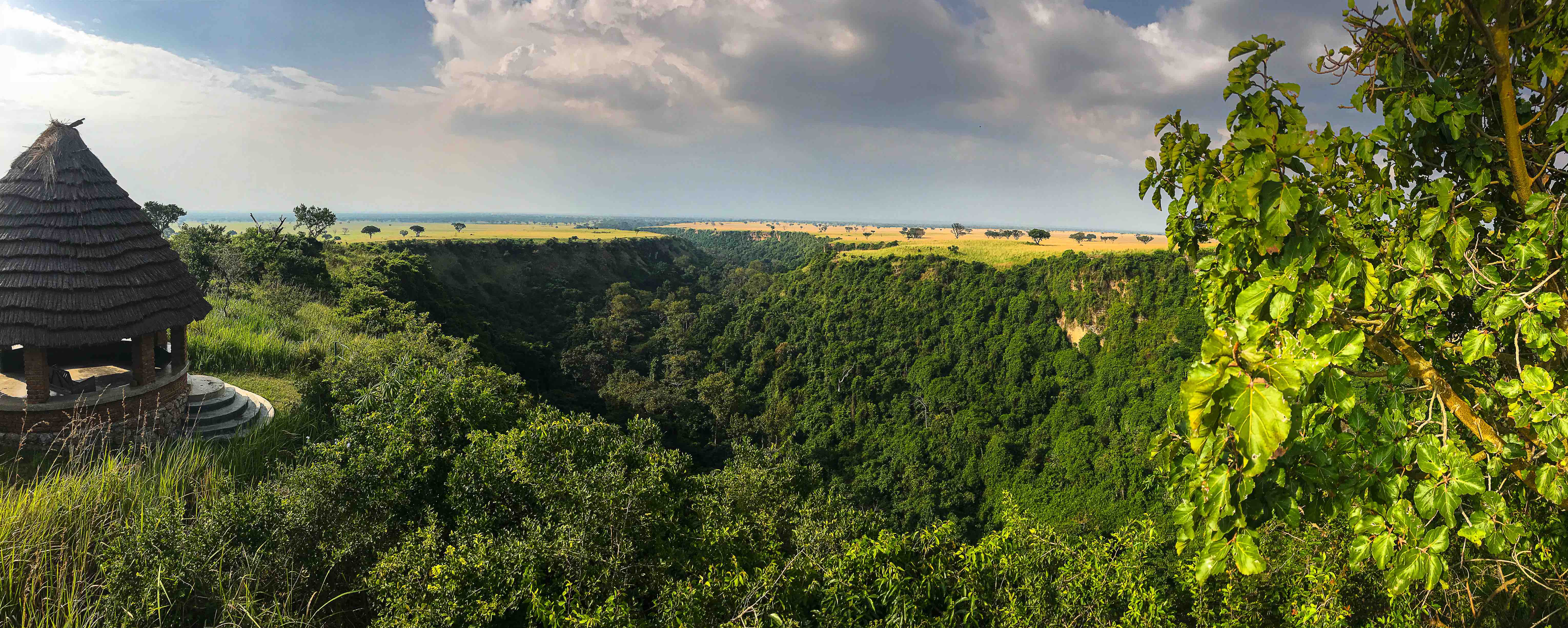
Craters, Plains, and Forest in a Single Glance
The park's terrain reads like a geological sampler. Volcanic explosion craters dot the southern reaches, some filled with turquoise mineral lakes, others carpeted in dense vegetation. Grassy plains stretch across the center, grazed by herds of Ugandan kob -- an endemic antelope so central to the national identity that it appears on Uganda's coat of arms alongside the crested crane. Tropical forest presses in from the edges, particularly along the Maramagambo Forest in the southeast, where chimpanzees swing through the canopy and bat caves harbor colonies numbering in the hundreds of thousands. This compression of habitats into a relatively compact area gives the park an ecological density that larger East African parks spread across greater distances.
A Name That Keeps Changing
Established in 1952 as Kazinga National Park, it was renamed Queen Elizabeth National Park in 1954 to commemorate Queen Elizabeth II's visit to Uganda that year. After independence and the turbulent years of Idi Amin's rule, it was renamed Rwenzori National Park in a wave of de-colonization. The name reverted to Queen Elizabeth after Amin's fall. Through every renaming, the park endured worse than politics. Poaching during the civil conflicts of the 1970s and 1980s devastated wildlife populations -- elephant numbers plummeted, and hippo counts dropped sharply. Recovery has been slow but steady, aided by international conservation funding and Uganda Wildlife Authority management. The park was designated a UNESCO Biosphere Reserve, recognition of both its ecological value and its fragility.
The Ishasha Lions and Their Fig Trees
The Ishasha sector, in the park's remote southern corner along the border with the Democratic Republic of Congo, is where the tree-climbing lions hold court. About 50 individuals spread across four prides inhabit the Ishasha plains, and during the heat of the afternoon they ascend into the broad canopies of fig trees. The sight is surreal: a 180-kilogram predator balanced on a branch, eyes half-closed, entirely at ease eight meters above the ground. Guides know the favored trees and scan them with binoculars from a distance. Below the lions, the Ishasha River marks the international border, its banks frequented by hippos and elephants. The campsite along this river is surrounded by woodland on three sides and the river on the fourth -- Congo visible just across the water.
Getting There by Wing or Wheel
Most visitors reach the park overland from Kampala, a journey of roughly six hours by bus through rolling green hills. The Katunguru Gate marks the main entrance. For those arriving by air, several airstrips serve the park: Kasese Airstrip on the northern boundary, Mweya Airstrip on the peninsula inside the park, and Kihihi Airstrip near the Ishasha sector. The Mweya Peninsula, jutting into the Kazinga Channel, is the park's tourism hub, with lodges perched on bluffs overlooking the water. From the peninsula, the view encompasses hippo-dotted waters, distant crater lakes, and the Rwenzori snowline -- a panorama that compresses equatorial Africa into a single, improbable frame.
From the Air
Located at 0.14S, 30.04E in western Uganda between Lake Edward and Lake George. Visible landmarks include the Kazinga Channel connecting the two lakes, volcanic crater lakes in the southern sector, and the Rwenzori Mountains to the northwest. Airstrips include Kasese (northern boundary), Mweya (inside the park on the peninsula), and Kihihi (near Ishasha sector). Recommended viewing altitude 3,000-5,000 ft AGL to appreciate the crater lakes and channel. Nearest major airport is Entebbe International (HUEN), approximately 300 km east.