Quirigua
On May 3, 738 AD, a king lost his head -- literally. Uaxaclajuun Ub'aah K'awiil, known to scholars as "18-Rabbit" and widely considered the greatest ruler Copan ever produced, was decapitated in a public ritual at Quirigua's Great Plaza. The man who ordered the execution was K'ak' Tiliw Chan Yopaat, a vassal king whom 18-Rabbit had personally installed on Quirigua's throne just fourteen years earlier. It was, by any measure, an extraordinary act of betrayal. And it transformed a minor trading outpost along the Motagua River into one of the most artistically ambitious cities in the Maya world.
A Vassal's Gambit
Quirigua had been founded around 426 AD as a satellite of Copan, itself an outpost of the great city of Tikal. For three centuries it served obediently, paying tribute in maize and cacao, hosting rituals supervised by Copan's kings. The site's strategic value lay in its position at the crossroads of two trade routes: one running from the Guatemalan highlands to the Caribbean coast, the other connecting Copan to the cities of the Peten Basin. Control the Motagua Valley, and you controlled the flow of jade, obsidian, and cacao through southeastern Mesoamerica. In 724, 18-Rabbit placed K'ak' Tiliw Chan Yopaat on Quirigua's throne as his loyal vassal. But the new king had other plans. By 734, he was already claiming the title of k'uhul ajaw -- holy lord -- on his monuments, a direct challenge to Copan's authority. Two years later, Wamaw K'awiil, the high king of distant Calakmul, paid Quirigua a visit. The timing was no coincidence. Calakmul and Tikal were locked in a generations-long struggle for supremacy across the Maya lowlands, and Copan was one of Tikal's oldest allies. By sponsoring Quirigua's rebellion, Calakmul could weaken Tikal's southeastern flank while gaining access to the Motagua trade route.
Stones That Shout
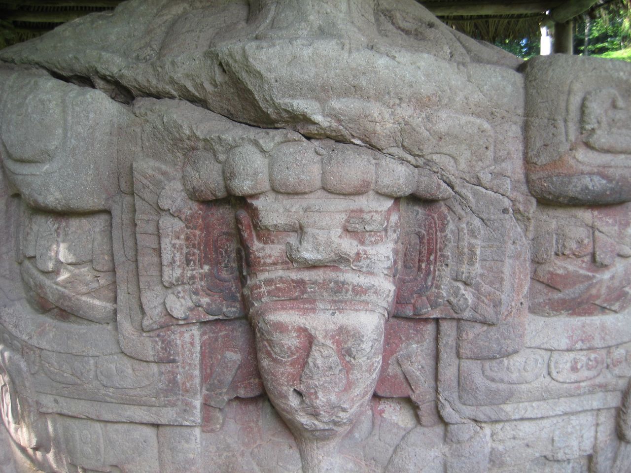
With Copan's king dead and its power broken, K'ak' Tiliw Chan Yopaat embarked on a building program that would define Quirigua for posterity. He erected massive stelae carved from single blocks of red sandstone quarried five kilometers away, each one an elaborate statement of royal power rendered in wrap-around sculptural style. Stela E, the largest stone the ancient Maya ever quarried, weighs approximately 65 tons and towers above visitors in the Great Plaza. The hieroglyphic texts on these monuments are considered among the most complex and beautiful of all Maya stone inscriptions, replacing standard bar-and-dot number glyphs with exquisitely carved full-figure representations of deities. K'ak' Tiliw Chan Yopaat may have used captured Copan sculptors to execute the work -- the style closely mimics Copan's own artistic tradition, as if the victor were deliberately claiming his former master's cultural heritage. After K'ak' Tiliw Chan Yopaat's death in 785, his successors developed something entirely original: zoomorphs, enormous boulders sculpted into composite mythological creatures bearing elements of toads, jaguars, crocodiles, and birds of prey. These sculptures remain marvels of Maya stoneworking.
Silence on the Motagua
Quirigua's glory was brief. The city never grew large -- its peak population probably never exceeded 2,000 people, scattered across the valley floor at a low density of about 130 structures per square kilometer. The last hieroglyphic texts were raised in 810. After that, Quirigua falls silent, swept up in the Classic Maya Collapse that depopulated cities across the lowlands. When trade stopped flowing along the Motagua, the city that had existed to control that trade lost its reason for being. Within a few years it was all but deserted. In the early Postclassic period, around 900 to 1200 AD, peoples linked to the Caribbean coast of the Yucatan Peninsula briefly reoccupied the site, leaving behind a reclining chacmool sculpture and some of the earliest metal artifacts found anywhere in the Maya area -- copper bells and ornaments that hint at the new trade networks replacing the old.
Rediscovery Among the Banana Groves
English artist Frederick Catherwood reached Quirigua in 1840, making it the first site he and explorer John Lloyd Stephens could claim to have discovered themselves. Catherwood's drawings of two stelae, published in Stephens's 1841 book Incidents of Travel in Central America, introduced the ruins to the wider world. Alfred Maudslay arrived in 1881 for a three-day visit that changed his life -- the ruins were the first pre-Columbian site he ever saw, and they inspired a permanent career in Central American archaeology. In 1910, the United Fruit Company bought the land for banana plantations but set aside 75 acres around the ceremonial center as an archaeological park, creating a pocket of jungle amid the orderly rows of fruit trees. The University of Pennsylvania led extensive excavations from 1974 to 1979, and UNESCO declared Quirigua a World Heritage Site in 1981. Today, one of its stelae appears on the Guatemalan 10-centavo coin -- a small tribute to a small city that, for a few decades in the eighth century, dared to defy an empire and left its defiance carved in stone.
From the Air
Located at 15.27N, 89.04W in the Motagua River valley of southeastern Guatemala, at just 75 meters elevation. The site sits on the broad floodplain where the valley widens toward the Caribbean coast. Best viewed from 2,000-3,000 feet AGL; look for the cleared archaeological park surrounded by banana plantations. The Motagua River runs approximately 1 km south of the ceremonial center. Nearest major airport: La Aurora International (MGGT) in Guatemala City, approximately 200 km to the southwest. Puerto Barrios (MGPB) on the Caribbean coast is closer at roughly 75 km northeast.