Raasay
Calum MacLeod spent ten years building a road with hand tools. Two miles of tarmac between Brochel Castle and the village of Arnish, carved from rock and heather by one man with a pick, a shovel, and a wheelbarrow. By the time the local council agreed to surface it, Calum and his wife were Arnish's last inhabitants. The story is pure Raasay -- an island where stubbornness and beauty exist in equal measure, where depopulation and devotion have been locked in a centuries-long struggle, and where the landscape carries the marks of every human hand that has worked it, from Mesolithic hunter-gatherers to the poet Sorley MacLean.
Between Skye and the Mainland
Raasay stretches fourteen miles long and four miles wide in the Inner Sound, separated from Skye by a narrow strait. The flat-topped summit of Dun Caan -- where James Boswell famously danced a Highland reel in 1773 -- offers views across to the Cuillin and the mainland. The island's geology is startlingly varied: Lewisian gneiss in the north gives way to Jurassic limestone and ironstone in the south, a diversity that attracted industrial attention in the early twentieth century. Brochel Castle, built by the MacSweens in the fifteenth century, perches on a pinnacle of rock on the northeast coast, its ruins still commanding the approach from the sea.
The MacLeods and the Prince
The MacLeods held Raasay from 1518, when Gillecallum, a younger son of the MacLeod chief of Lewis, was granted title. Although Protestant, the MacLeods of Raasay supported Bonnie Prince Charlie during the 1745 Jacobite rising. After Culloden, the Prince spent two days hiding on the island. The retribution was savage: in July 1746, troops of the Campbell of Argyll Militia and the crew of HMS Furnace burned Raasay House and many other dwellings, confiscated and slaughtered all livestock, and assaulted two women. The laird was taken prisoner and held on a prison hulk in the Thames. Yet when Johnson and Boswell arrived in 1773, they found "nothing but civility, elegance, and plenty" -- the carpet rolled back for dancing, six-and-thirty guests at supper, and ladies singing Gaelic songs into the night.
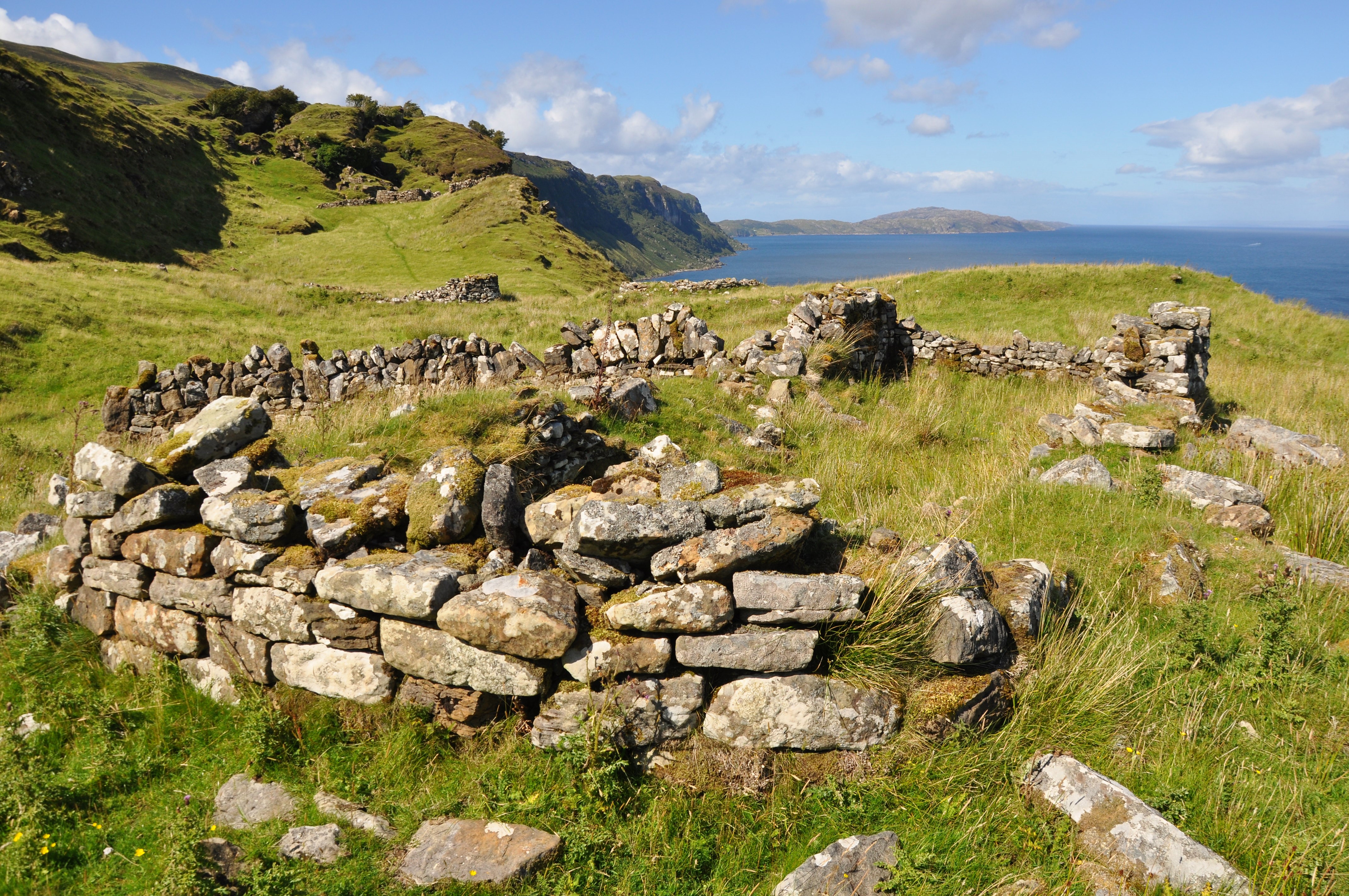
Cleared and Emptied
In 1843, the last MacLeod laird, deep in debt, sold Raasay for 35,000 guineas to George Rainy. After the Highland Potato Famine, Rainy decided to convert arable land to sheep farming. His method of removing the tenants was to ban marriage. Townships along the east coast were emptied. Hallaig was cleared between 1852 and 1854; the ruins of at least 25 buildings remain visible. Boatloads of emigrants left for Portland, Australia. By the early twentieth century, the island had been bought by William Baird and Company to mine its ironstone, and Inverarish Terrace -- two facing rows of workers' houses -- was built to house the workforce. During World War I, the northern part of the village was converted into a prisoner-of-war camp with barbed wire and sentry boxes. The mine closed, the government bought the island in 1922, and the slow work of recovery began.
Time, the Deer, Is in the Wood
The poet Sorley MacLean was born in Osgaig on Raasay's west coast. His most famous poem, Hallaig, transforms the emptied township into a landscape where the dead return as birch trees and the living are shadows. "Time, the deer, is in the Wood of Hallaig" -- a line that captures both the relentless passage of history and the way memory inhabits a place long after its people have gone. MacLean wrote in Gaelic, and his work gave voice to the wound of the Clearances with a power that transcended language. Today Raasay's population has risen slightly to 187. The island has its own distillery, producing what has been called its "first legal single malt," and a unique subspecies of bank vole found nowhere else on Earth. Calum's road is still there, still used, still a monument to what one person can build when no one else will.
From the Air
Located at 57.40N, 6.03W in the Inner Sound between Skye and the Scottish mainland. The island is approximately 14 miles long, clearly visible from altitude. The flat-topped summit of Dun Caan (443m) is a distinctive landmark. No airstrip; nearest airports are Broadford (Skye) and Inverness (EGPE). Best viewed at 3,000-5,000 feet. The ferry runs from Sconser on Skye to Churchton Bay on Raasay.