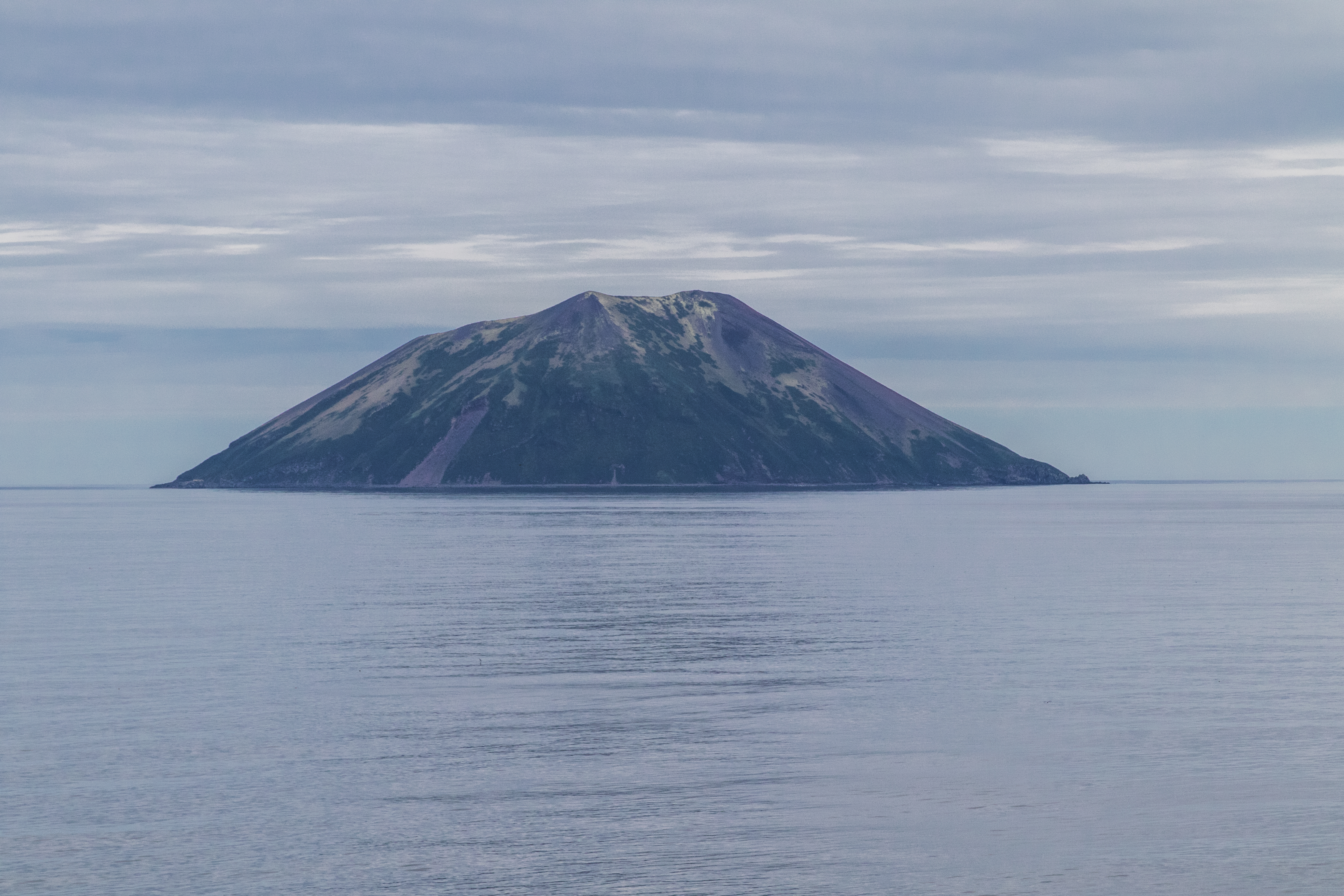
Raikoke
The Ainu called it hellmouth. At just 2.5 kilometers long and 2 kilometers wide, Raikoke barely qualifies as an island — more a volcanic cone that happens to break the surface of the Sea of Okhotsk. But in June 2019, this 4.6-square-kilometer speck near the center of the Kuril Islands chain reminded the world that geological significance has nothing to do with size. The eruption sent a column of ash and sulfur dioxide into the stratosphere, where satellite instruments tracked it as it circled the Earth three times.
Anatomy of a Stratovolcano
Raikoke is roughly circular, a basalt stratovolcano rising from a submarine terrace 130 meters below the surface to a summit of 551 meters above sea level. The crater at the top is 700 meters wide and 200 meters deep, with lava flows extending along the island's eastern half. The volcano has erupted in 1765, 1778, 1924, and 2019. The 1778 and 1924 eruptions were both rated VEI-4 or greater on the Volcanic Explosivity Index — the same rating assigned to the 2018 eruption of Anak Krakatoa. The 1778 eruption is the only one known to have caused fatalities: fifteen people were killed by falling lava bombs. Who they were — Ainu hunters, Russian fur traders — the record does not say.
A Plume That Circled the World
The 2019 eruption produced something scientists rarely observe: a stable, self-sustaining anticyclonic vortex of sulfur dioxide in the stratosphere. The European Space Agency's Sentinel-5P satellite detected the plume clustering into distinct structures within 72 hours of the eruption. One mass of sulfur dioxide, lofted to extraordinary altitude by the radiative heating of volcanic ash, began spinning in an anticyclonic pattern — confirmed independently by ESA's Aeolus satellite and NASA's CALIPSO mission. The swirling mass circled the globe three times before dissipating. Such long-lived, self-containing anticyclonic structures had been associated with large wildfires, but stable volcanic plumes of this kind are seldom reported. Raikoke's eruption gave atmospheric scientists a rare natural laboratory.
Rookery and Refuge
Between eruptions, Raikoke belongs to the animals. The island is one of five major Steller sea lion rookeries in the Kuril Islands. In spring and summer, it hosts one of the largest northern fulmar aggregations in the chain, along with nesting colonies of crested auklets, parakeet auklets, pigeon guillemots, and black-legged kittiwakes. In 1883, Captain Henry James Snow reported that some 15,000 northern fur seals inhabited the island. By the 1890s, overexploitation by fur hunters had reduced the population to a few dozen. No fur seals reproduce on Raikoke today. The sea lions and seabirds that remain share the island with no permanent human residents — Raikoke was visited by Ainu hunting and fishing parties but never permanently settled.
Flags Over Basalt
Raikoke appears on an official 1644 map of Matsumae Domain, a feudal territory of Edo-period Japan, and these holdings were confirmed by the Tokugawa shogunate in 1715. Russia subsequently claimed the island, and sovereignty initially passed to Russia under the Treaty of Shimoda. The 1875 Treaty of Saint Petersburg returned it to Japan along with the rest of the Kuril chain. After World War II, the Soviet Union took control, and Raikoke is now administered as part of Sakhalin Oblast. It was formerly part of Shimushu District of Nemuro Subprefecture in Hokkaido — a Japanese administrative designation that no longer carries any practical authority over an uninhabited Russian volcano 16 kilometers from the island of Matua.
The Mouth Still Speaks
Raikoke sits 16 kilometers from Matua, its nearest neighbor in the chain. From the air, the island looks deceptively peaceful: a green-capped cone rising from dark water, seabirds wheeling around its cliffs. The crater's 200-meter depth is hidden from view unless you pass directly overhead. But the geological record is clear. Four eruptions in 254 years, two of them VEI-4 events, and the most recent producing atmospheric phenomena that scientists are still studying. The Ainu name was not metaphorical. Raikoke is a mouth in the Earth's crust, and it speaks when it chooses.
From the Air
Located at 48.28°N, 153.25°E near the center of the Kuril Islands chain, approximately 16 km from Matua Island. Raikoke is a small circular volcanic island (2.5 km x 2.0 km) with a summit of 551 m. The steep-walled crater (700 m wide, 200 m deep) is visible from above. No airfield exists on the island. Nearest airports include those on the more populated southern Kuril islands (Iturup Airport UHSI) and the gateway hub of Yuzhno-Sakhalinsk (UHSS). Caution: this is an active volcano — last erupted June 2019. Volcanic emissions may be present. Expect subarctic weather, persistent fog, and strong winds. The Sea of Okhotsk lies to the west, the Pacific to the east.