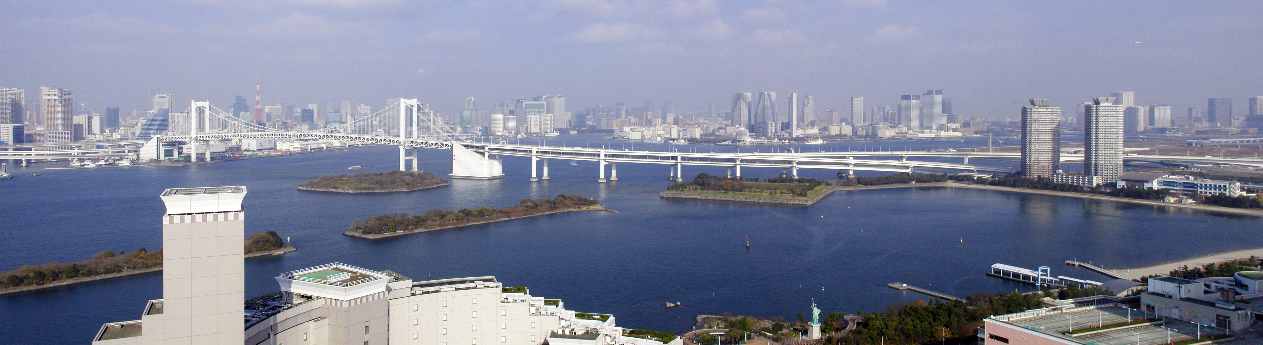
Rainbow Bridge (Tokyo)
The name was chosen by public vote, and the public chose well. Tokyo's Rainbow Bridge stretches 798 meters across the northern reaches of Tokyo Bay, connecting the old city at Shibaura Pier to the reclaimed island of Odaiba -- and in doing so, it connected two eras of Tokyo. Construction began in 1987, when Odaiba was still an ambitious urban experiment on landfill, and when the bridge opened in 1993, it gave the waterfront district the one thing it had lacked: a dramatic entrance. Kawasaki Heavy Industries built it, but the city claimed it. Within a year, the bridge's white towers and graceful cable lines had become as synonymous with the Tokyo skyline as the older landmarks it frames.
Two Decks, Three Lives
The Rainbow Bridge is a double-decker suspension bridge with a main span of 580 meters, and it lives three separate lives simultaneously. The upper deck carries the Shuto Expressway's Daiba Route, funneling the ceaseless flow of Tokyo's automobile traffic high above the water. Below, the lower deck splits its duties: the Yurikamome automated transit line runs along the center, flanked by roadway lanes for local traffic and, on the outermost edges, pedestrian walkways. The arrangement is a lesson in Japanese spatial efficiency -- every meter of the bridge serves multiple purposes. The white-painted towers that support the cables were deliberately chosen to harmonize with the Tokyo skyline as viewed from Odaiba, ensuring the bridge complements rather than competes with the city behind it.
Walking Between Two Views
The pedestrian walkways on the lower deck offer two completely different experiences of Tokyo, separated by the width of the bridge. Walk the north side and the view is Tokyo Tower, the harbor's inner waterfront, and the dense commercial core of Minato ward stacked against the sky. Walk the south side and the bay opens wide -- container ships, open water, and on clear winter days, the unmistakable silhouette of Mount Fuji floating on the western horizon. Access hours change with the seasons: summer walkers can stay until 9 PM, catching the bridge's nightly illumination from below, while winter hours close at 6 PM. Cyclists are welcome but must push their bikes across -- the walkways are too narrow for riding. The walk from Shibaura-futo Station on the mainland side takes roughly 30 minutes one way, a surprisingly meditative stretch in the middle of one of the world's largest cities.
Light Show on the Bay
After dark, the Rainbow Bridge transforms. Lamps along the supporting cables illuminate in three colors -- red, white, and green -- powered by solar energy collected during the day. The colors are the same as the Japanese flag plus green, and the effect turns the bridge into a luminous arc across the black water of the bay. On special occasions, the lighting shifts to rainbow colors, finally matching the bridge's name. The nighttime view of the bridge from Odaiba's waterfront promenades has become one of Tokyo's most photographed scenes, rivaling the neon canyons of Shinjuku and the scramble crossing at Shibuya. Couples line the waterfront parks on both sides. Pleasure boats drift beneath. The bridge has become the backdrop for countless films, television dramas, and anime -- a piece of infrastructure that transcended its purpose to become a symbol.
Odaiba's Lifeline
The Rainbow Bridge did not merely connect Odaiba to the mainland; it made Odaiba possible. Before the bridge, the reclaimed island's ambitious entertainment complexes, shopping malls, and convention centers were stranded on landfill accessible only by boat or a long drive around the bay. The bridge turned a 45-minute journey into a 15-minute crossing. The Yurikamome line that runs across its lower deck became the primary transit artery for the entire waterfront district, ferrying millions of commuters and tourists annually. Today, Odaiba hosts the Fuji Television headquarters with its distinctive sphere, teamLab exhibitions, hot spring resorts, and a replica Statue of Liberty that gazes back at the bridge. The Rainbow Bridge made all of it viable -- a piece of engineering that reshaped Tokyo's geography as decisively as the original landfill that created the island beneath it.
From the Air
Located at 35.636N, 139.764E spanning Tokyo Bay between Shibaura and Odaiba. From the air, the suspension bridge is immediately recognizable as a white-towered arc crossing the northern portion of Tokyo Bay, with the distinctive Fuji Television sphere building on the Odaiba side. Nearest airports: Tokyo Haneda (RJTT) approximately 5 nm south-southwest, Narita International (RJAA) approximately 38 nm east. Best viewed at 1,500-3,000 feet AGL. At night, the tri-color cable lighting makes the bridge visible from considerable distance. The bridge aligns roughly northeast-southwest and serves as a strong visual reference for the Odaiba waterfront area.