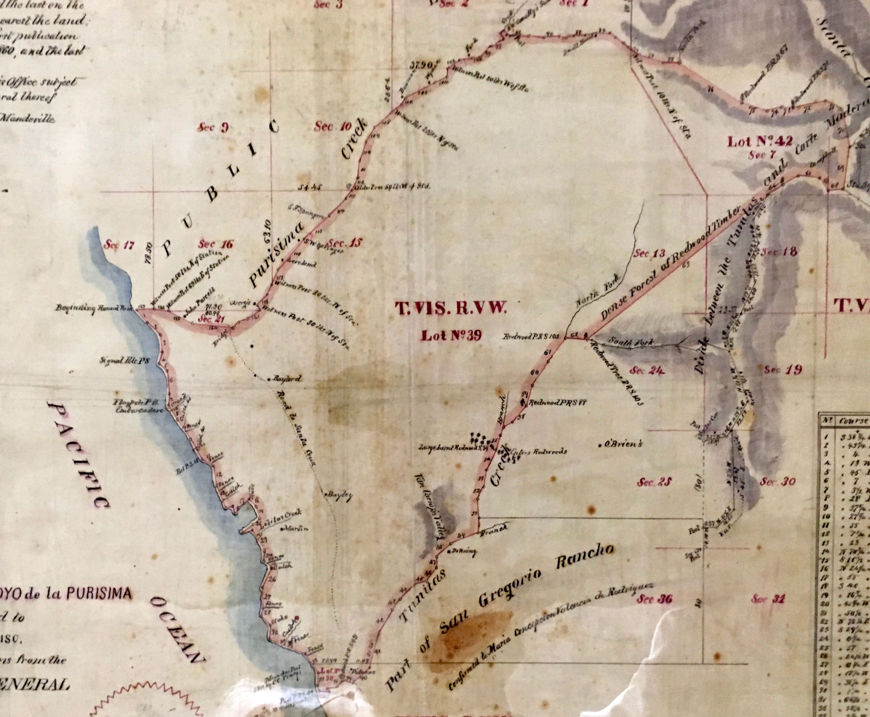
Rancho Canada de Verde y Arroyo de la Purisima
The name translates roughly as "ranch of the green glen and brook of the Purest," a mouthful of poetry for a piece of paper that would take nearly three decades to become legally binding. In 1838, Mexican Governor Juan B. Alvarado granted 8,906 acres of Pacific coastline to Jose Maria Alviso, a military officer from San Jose. The land stretched from Purisima Creek south to Tunitas Creek, encompassing what would become the village of Purissima and the tiny community of Lobitos. By the time the grant was finally patented under American law in 1865, Mexico had lost California, the United States had fought a civil war, and the Alviso family had spent thirteen years navigating a legal system designed by their conquerors.
Brothers and Boundaries
Jose Maria Alviso petitioned for the grant not for himself but for his brother, Jose Antonio Alviso. Jose Antonio was the eldest son of Jose Ygnacio Alviso and Margarita Bernal, born in 1796 into one of California's prominent ranchero families. He married Maria Antonia de Jesus Pacheco in 1816 and built a life within the mission-era social order that was already beginning to crumble. The grant covered two square leagues of coastal land, a vast expanse of rolling grasslands, creek-cut ravines, and bluffs overlooking the Pacific. Its boundaries ran along waterways whose names -- Purisima, Tunitas -- still mark the landscape today.
From Mexican Soil to American Courts
The Treaty of Guadalupe Hidalgo in 1848 promised that Mexican land grants would be honored by the United States, but the reality was far more complicated. The Land Act of 1851 required every grant holder to prove their claim before a Public Land Commission, a process that placed the burden of proof on families who often had little more than a hand-drawn map and a governor's signature. Jose Antonio Alviso filed his claim in 1852. The United States government appealed, challenging the grant's validity. The case climbed all the way to the U.S. Supreme Court, which rejected the government's appeal. In 1865, the grant was formally patented to Jose Antonio Alviso, twenty-seven years after the original Mexican decree.
The Land's Long Afterlife
The rancho's boundaries shaped the development of the San Mateo County coast for generations after the Alviso family's tenure ended. The ghost town of Purissima rose and fell within its borders. Martins Beach, the site of California's most famous modern beach-access dispute, sits on land once part of the grant. The rancho system itself was a brief chapter in a longer story: the Ohlone people had lived on this coast for thousands of years before Spanish colonization, and the Mexican period lasted barely two decades before American annexation. Yet the property lines drawn in 1838 persist in deed records and courthouse files, invisible boundaries that still determine who can walk to the water and who cannot. The original hand-drawn plat map survives in the Bancroft Library at UC Berkeley, its ink fading, its boundaries as consequential as ever.
From the Air
Located at 37.402°N, 122.384°W. The rancho covered the coastline from Purisima Creek to Tunitas Creek in San Mateo County. The area is visible as agricultural land and coastal bluffs along Highway 1 south of Half Moon Bay. Nearest airport: Half Moon Bay Airport (KHAF), 5 nm north. KSFO is 20 nm northeast. Best viewed at 2,000-3,000 ft AGL following the coastline.