Rancho de las Pulgas
Drive the length of Alameda de las Pulgas today and you pass through San Mateo, Belmont, San Carlos, Redwood City, Atherton, and Menlo Park in comfortable suburban sequence. The road's name translates to Avenue of the Fleas. Nearly ten miles long, it traces the spine of what was once Rancho de las Pulgas, a 35,240-acre Spanish land grant that gave these cities their geographic bones and their curious entomological heritage.
The Name Behind the Name
Before the Spanish arrived, the Lamchin, an Ohlone tribe, lived in the area around present-day San Carlos. Their main village was called Cachanigtac, a name that appears to contain a word for vermin. Spanish missionaries translated the concept as Las Pulgas: the Fleas. When the Spanish colonial government created a land grant in the area, the name stuck. In 1795, Governor Diego de Borica made the provisional grant of Las Pulgas to Jose Dario Arguello. The grant stretched about one league from San Francisco Bay to the hills, bounded by San Mateo Creek on the north and San Francisquito Creek on the south. The southern boundary at San Francisquito Creek would later define the eastern portion of San Mateo County's southern border.
A Widow's Claim
The grant's legal history is a case study in California land politics. Jose Dario Arguello's son Luis Antonio served as California's first native-born governor before dying in 1830. In 1835, Mexican Governor Jose Castro granted the four-square-league Rancho de las Pulgas to Luis Antonio's widow, Maria Soledad Ortega de Arguello, and his heirs. After the Mexican-American War, the 1848 Treaty of Guadalupe Hidalgo promised to honor existing land grants. But the Land Act of 1851 required claimants to prove their titles before a Public Land Commission. The Arguello heirs filed for twelve square leagues in 1852; the commission confirmed only four, and the U.S. Supreme Court affirmed that ruling.
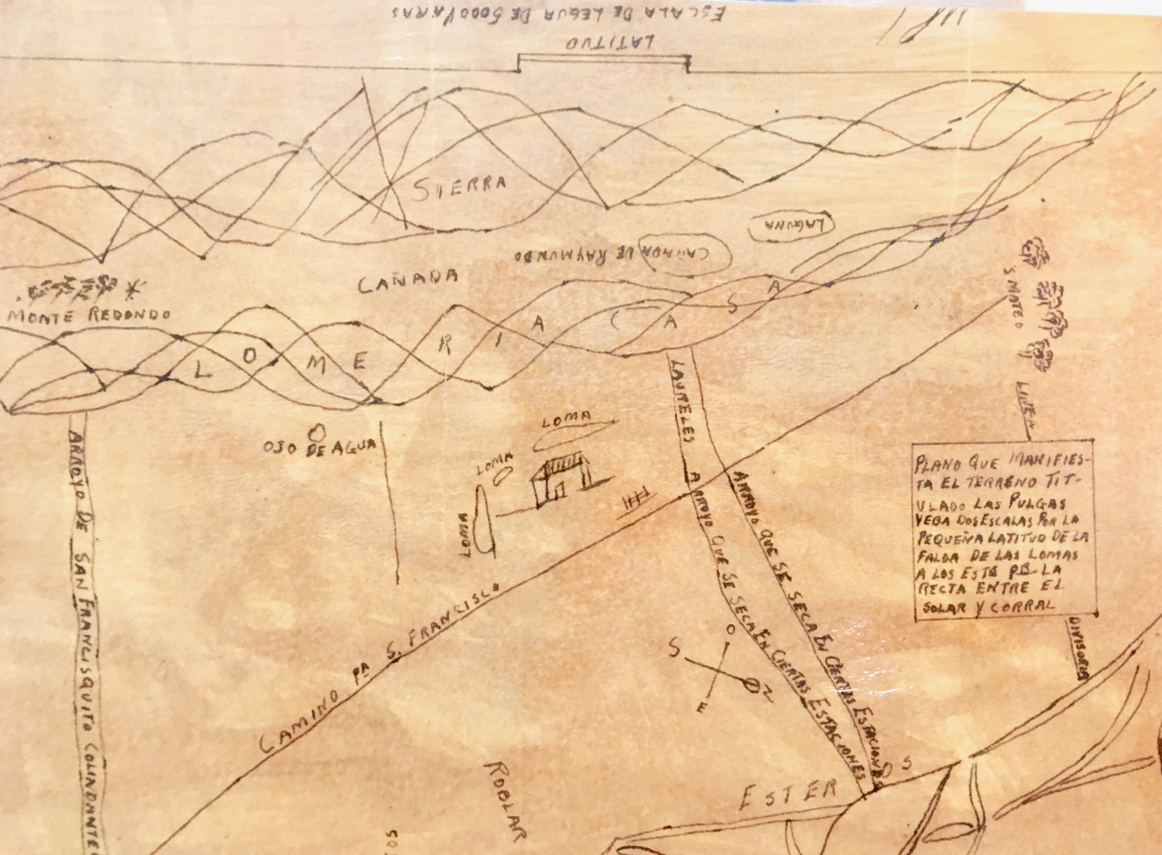
Twice the Size, Twice the Trouble
When the official survey was completed in 1856, the patent issued in 1857 covered 35,240 acres, nearly double the size of the original four-league grant and contrary to the Supreme Court's language. The property was divided among Maria Soledad Ortega de Arguello, who received one undivided half; Jose Ramon Arguello, one quarter; Luis Antonio Arguello, one tenth; and the family's lawyer, Simon Monserrat Mezes, three twentieths. Mezes had handled the land patent process and took his fee in acreage. The generous patent created a new problem: the boundaries of Rancho de las Pulgas now overlapped with neighboring Rancho Canada de Raymundo. It took an Act of Congress in 1878 to resolve the conflict.
The Flea Road
Alameda de las Pulgas survives as a physical remnant of the grant, connecting the cities that grew on its former acreage. The word alameda means a row of trees or a tree-lined street, so the full name translates roughly as Tree-Lined Avenue of the Fleas. It is a name that real estate agents in Atherton and Menlo Park have learned to explain with good humor. The grant's legacy extends beyond road names. The creek boundaries that defined the rancho became the boundaries of San Mateo County itself. The land grant system that parceled California into ranchos after secularization of the missions created the template on which the Peninsula's suburban geography was eventually drawn, one flea-bitten acre at a time.
From the Air
Located at 37.46°N, 122.20°W on the San Francisco Peninsula. The former rancho encompasses modern San Mateo, Belmont, San Carlos, Redwood City, Atherton, and Menlo Park. San Carlos Airport (KSQL) sits near the center of the historical grant area. Alameda de las Pulgas is visible as a north-south arterial road running through the Peninsula cities. Crystal Springs Reservoir marks the western boundary area.