Randolph Air Force Base
First Lieutenant Harold Clark was a dispatch officer in the motor pool at Kelly Field when he heard that the Army Air Corps needed a new training base near San Antonio. Before enlisting for World War I, Clark had trained as an architect. On the back of old dispatch sheets, he began sketching an idea that no one had tried before: a circular airfield, with parallel runways aligned to the prevailing winds and all facilities arranged by function in four quadrants between them. No more landing approaches over hangars. No more buildings where they did not belong. Clark brought his drawings to General Frank P. Lahm's executive officer, who brought him straight to the planning board. The design was approved on August 16, 1928, and what followed was the largest construction project undertaken by the Army since the Panama Canal.
An Air City from Scratch
Clark's original circular concept was refined extensively by George B. Ford, a city planner and civilian advisor to the War Department's Quartermaster Corps. Ford's final layout added a dramatic entrance boulevard terminating at Washington Circle, with three notable buildings positioned around it. The 2001 National Park Service nomination for the Randolph Field Historic District called it 'clearly the work of a master planner.' Every structure on the base, including the hangars, was built in Spanish Colonial Revival style. At the center rose Building 100, a headquarters topped by a massive water tower that earned the nickname 'the Taj Mahal.' Although barely half-completed, the field was dedicated on June 20, 1930, with 15,000 people watching a flyby of 233 planes. The mayor of San Antonio, C.M. Chambers, formally presented what he called the 'West Point of the Air' to Maj. Gen. James Fechet, Chief of the Air Corps. The nickname stuck permanently.
The Captain on the Naming Committee
The base bears the name of Captain William Millican Randolph, a native of Austin and a graduate of Texas A&M. On February 17, 1928, Randolph was killed in the crash of a Curtiss AT-4 Hawk during takeoff from Gorman Field, Texas. At the time of his death, he was serving on the very committee tasked with choosing a name for the new airfield. His colleagues gave the field his name. Randolph is buried at Fort Sam Houston National Cemetery. By November 1931, the Primary Flying School opened at the base. Between October 1931 and March 1935, more than 2,000 candidates reported for pilot training; 47 percent graduated. By 1932, the field had 251 primary trainers, mostly the Consolidated PT-3 'Trusty,' and seven auxiliary fields within a ten-mile radius handled the overflow of student takeoffs and landings.
From Biplanes to B-29s
The Air Corps Act of 1926 mandated that 90 percent of all commissioned Air Corps officers be rated pilots. That requirement funneled nearly every new officer through Randolph's training program. By 1936, the Stearman PT-13 Kaydet was appearing in the skies over San Antonio. When World War II expanded the mission, Randolph created the Central Instructors School in March 1943, producing 15,396 instructor graduates before the program moved to Waco Field in 1945. The base then shifted to B-29 Superfortress transition training. During the war, Randolph also fielded a football team, the Ramblers, whose 1944 squad included former NFL Rookie of the Year Bill Dudley and All-American running back Glenn Dobbs alongside eight other former NFL players. They went undefeated in 11 games and were ranked third in the nation by the AP poll. A 1935 Hollywood film, 'West Point of the Air,' had already been shot on location at Randolph, cementing the base's fame beyond military circles.
The Jet Age and Beyond
Randolph became Randolph Air Force Base on January 13, 1948, when the newly independent Air Force took over. Through the Korean War, the base trained crews for B-29 Superfortresses, ultimately producing 21,519 crew members. The Lockheed T-33 Shooting Star served as the workhorse trainer through the 1950s and 1960s. In the early 1960s, Randolph became the Air Force's primary pilot instructor training base as the service moved all undergraduate pilot training into jet aircraft. The Northrop T-38 Talon and Cessna T-37 defined a generation of training. During the Vietnam War buildup, 1,269 pilots earned their wings at Randolph before undergraduate pilot training shifted elsewhere in 1971. The base became the sole source of instructor pilots for the entire USAF. On October 1, 2010, Randolph merged with Lackland Air Force Base and Fort Sam Houston to form Joint Base San Antonio, but the 12th Flying Training Wing continues to operate from the circular field, training instructor pilots in the T-6A Texan II, T-38C Talon, and T-1A Jayhawk.
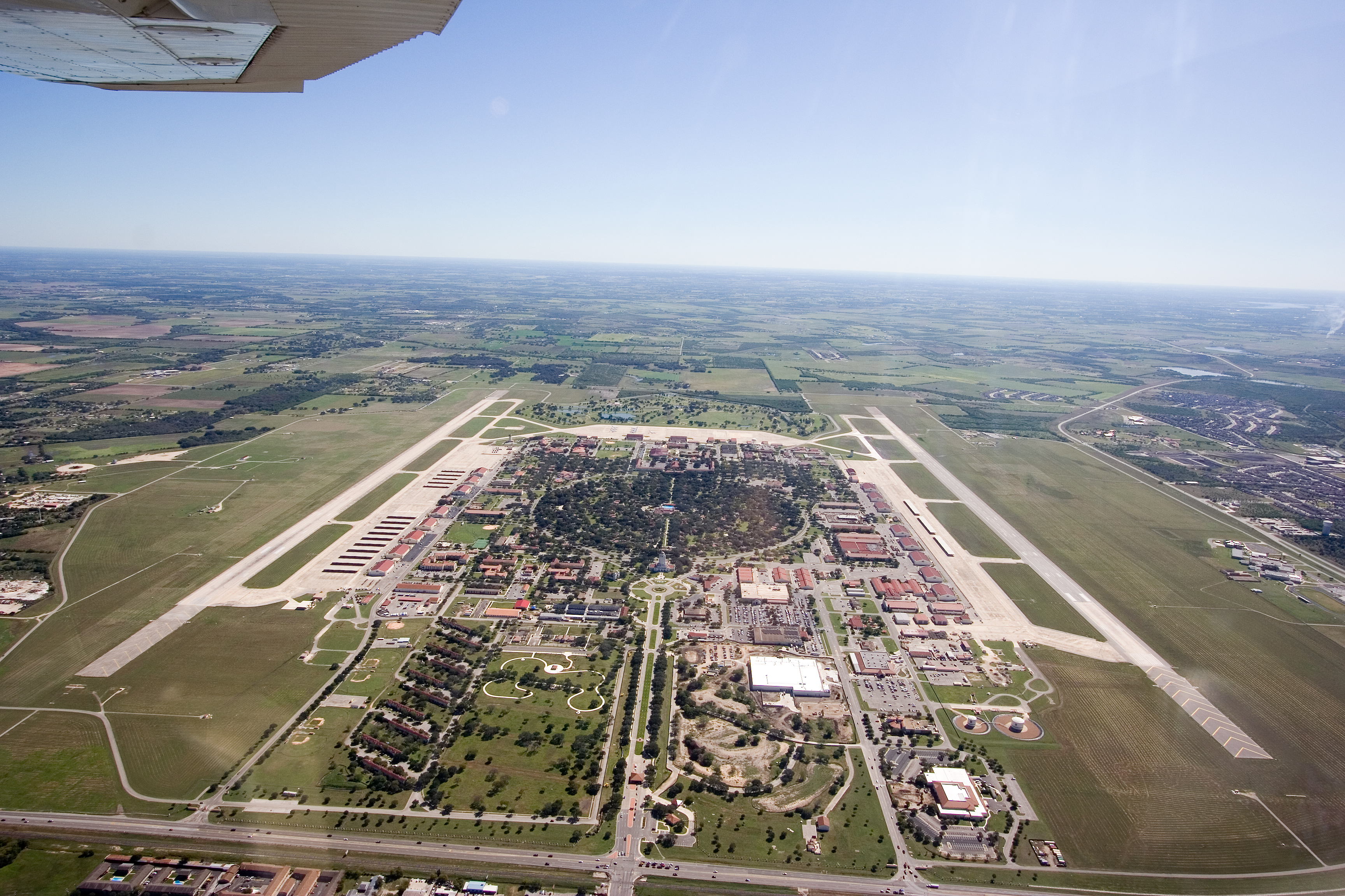
A Landmark in the Round
The Randolph Field Historic District is a National Historic Landmark encompassing 350 contributing buildings across 405 acres, most constructed between 1929 and 1932. From the air, the layout remains unmistakable: a perfect circle of roads at the center, radiating outward between parallel runways, every building in matching Spanish Colonial Revival architecture. The Taj Mahal headquarters still dominates the skyline. It is one of three school districts in Texas whose boundaries are exactly coterminous with a military installation. Harmon Drive, the main entrance leading to the Taj, has been repaved, and a new base exchange has been built, but the essential geometry that Harold Clark first sketched on the back of motor pool dispatch sheets in 1927 is still the shape of the place. Nearly a century later, planes still land along the lines he drew.
From the Air
Located at 29.529°N, 98.279°W, approximately 18 nm east-northeast of downtown San Antonio. The base's distinctive circular layout is clearly visible from altitude and is one of the most recognizable airfield designs in the United States. ICAO code: KRND. Caution: active military airfield with training operations. The 'Taj Mahal' (Building 100) water tower is visible at the center of the circular road pattern. Nearby airports: KSAT (San Antonio International, 15 nm NW), KSSF (Stinson Municipal, 18 nm SW). An auxiliary field, Seguin Field (KSEQ), operates 12 nm east-northeast with an 8,350-ft runway.