Raurimu Spiral
There is no place on earth from which you can see the entire Raurimu Spiral. That is part of what makes it remarkable. When Robert Holmes, a Public Works Department engineer, devised the route in 1898, he reportedly visualised the entire layout in his imagination, a railway that would loop back on itself, thread through two tunnels, execute three hairpin bends, and complete a full circle, all to climb 132 metres over a straight-line distance of just two kilometres. The Institute of Professional Engineers of New Zealand has designated it a significant engineering heritage site. Pilots and helicopter passengers glimpse sections of the spiral from the air, but the bush and terrain conspire to hide the full picture. The railway was designed to solve a problem that had stumped surveyors for nearly two decades, and it did so with a solution no one could fully see, not even from above.
The Problem Nobody Could Solve
During the construction of the North Island Main Trunk railway's central section, engineers faced a formidable obstacle. Between Raurimu and National Park, the land rose 200 metres in about five kilometres, a gradient of 1 in 24, far too steep for any railway. The maximum workable gradient for heavy steam trains was 1 in 50. Surveyors spent the 1880s searching for an alternative, but the only viable route they found required a 20-kilometre detour and nine massive viaducts, and even then, the gradient would have exceeded the limit. The terrain between the North Island Volcanic Plateau to the east and the valleys and gorges of the Whanganui River to the west seemed to offer no passage that a locomotive could reasonably climb. For nearly two decades, this section remained the critical bottleneck in the plan to connect Auckland and Wellington by rail.
Holmes Sees What Others Cannot
The breakthrough came from a surveyor working under Robert Holmes. In 1898 he proposed a line that looped back upon itself and spiralled upward with the aid of tunnels and bridges, maintaining a gradient of 1 in 52. The scheme was expensive and labour-intensive, but it was still cheaper than the nine-viaduct alternative proposed by engineers Browne and Turner along the Piopiotea River. Holmes's design used the natural contours of the land so effectively that no viaducts were needed, only two short tunnels: the Lower Spiral Tunnel at 384 metres and the Upper Spiral Tunnel at 96 metres. Compare that to the railway spirals of Switzerland, which generally require extensive tunnelling deep inside mountainsides. Holmes achieved the same vertical gain largely in the open air, reading the landscape and bending the track to follow its folds.
Anatomy of a Spiral
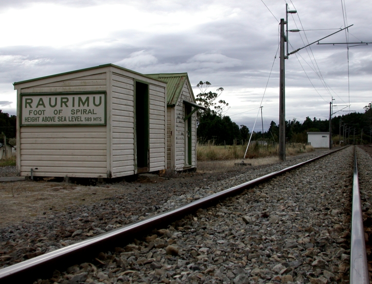
From the north, a train passes Raurimu station and enters a 200-degree horseshoe curve to the left, climbing above the track it has just travelled. Two sharp bends to the right follow, then the line threads through the Lower and Upper Spiral Tunnels. After the tunnels, the train completes a full 360-degree circle, crossing over the Lower Spiral Tunnel 23 metres below, the same tunnel through which it passed only minutes before. Two kilometres further south, two more sharp bends, right then left, complete the ascent. In total, a train has risen 132 metres and travelled 6.8 kilometres to cover a straight-line distance of two kilometres. Some curves are only 150 metres in radius, tight enough that long trains can see their own tail. According to railway folklore, a locomotive engineer once slammed on the emergency brakes after spotting a light ahead, only to realise it was the lamp on his own guard's van, visible on a nearby section of the spiral.
A Legacy Written in Contour Lines
The Raurimu Spiral opened the way for the completion of the North Island Main Trunk railway, which was fully operational by 1909 and transformed the economic geography of the North Island. The spiral remains in daily use, carrying freight trains between Auckland and Wellington through terrain that once seemed impassable. When the central section was electrified in the 1980s as part of the Think Big energy program, electric locomotives proved they could haul heavier loads at higher speeds up the spiral's grades than their diesel predecessors. The spiral has never been bypassed or replaced. Holmes's design was so well fitted to the landscape that no one has found a better solution in more than a century. Heritage New Zealand lists it as a Category 1 historic place, the highest level of recognition for a structure that cannot be seen whole from any single vantage point, a piece of engineering that asks you to trust the contour lines and take the long way up.
From the Air
The Raurimu Spiral is located at 39.12S, 175.40E in the central North Island, between Raurimu and National Park on the North Island Main Trunk railway. From the air at 2,000-4,000 feet AGL, sections of the spiral are visible threading through native bush, but the full layout is difficult to discern even from directly above due to tree cover. The volcanic peaks of Tongariro National Park, including Mount Ruapehu, Mount Ngauruhoe, and Mount Tongariro, are visible to the east. The nearest airports are Taupo (NZAP) approximately 60 km to the east and Ohakea (NZOH) approximately 100 km to the south. Best viewed from helicopter altitude on clear days; cloud and rain are frequent in this area.