Rayen Castle
When the 2003 earthquake flattened Arg-e Bam, the world mourned the loss of what was widely considered the largest adobe structure on Earth. A hundred kilometers to the northwest, another mud-brick citadel stood quietly intact. Rayen Castle -- Arg-e Rayen -- had weathered the same seismic region, the same desert climate, the same centuries of neglect, and emerged whole. It is the second-largest adobe fortress in the world, covering more than 22,000 square meters of walled compound at the foot of the Hezar Mountains, and it offers something increasingly rare: a chance to walk through a Sassanid-era citadel that still stands as its builders intended.
Walls That Held Against the Arabs
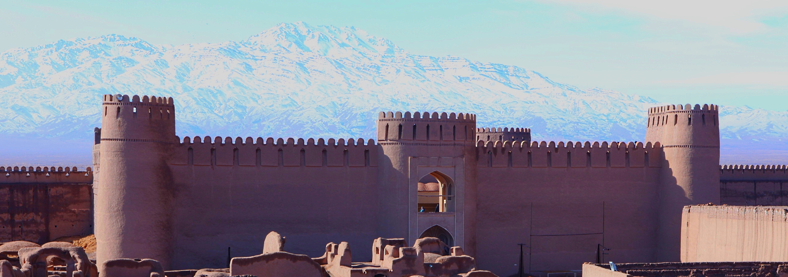
Rayen Castle's foundations likely date to the Sassanid era, between the third and seventh centuries AD, though the complex was expanded and renovated during subsequent Islamic periods. The walls are entirely adobe -- sun-dried mud brick rising to heights of ten meters or more, reinforced by sixteen defensive towers positioned at corners and midpoints along both the inner and outer perimeters. Fifteen of these towers served as watchtowers and defensive positions. The sixteenth, known as the mother tower, functioned as an information hub, relaying signals across the compound. During the reign of the last Sassanian king, Yazdegerd III, Arab forces swept through Kerman and its surrounding settlements. Rayen held. Contemporary accounts credit the citadel's high walls and strategic positioning for repelling the invaders, making it one of the few fortifications in the region to resist the Arab conquest.
A City Behind the Gates
Step through the single grand entrance on the eastern wall and the citadel reveals itself as a complete urban settlement, not merely a fortress. The interior was divided into three distinct quarters reflecting the social hierarchy of its time: the Khan-Neshin, where the ruling khans lived; the Ayan-Neshin, home to lords and wealthy merchants; and the Aameh-Neshin, the common quarters. A covered bazaar runs from the entrance gate inward, its narrow corridors designed to channel airflow and combat the desert heat. Beyond the bazaar lies the speech square, an open gathering point where government announcements were read aloud to the public. Deeper inside stand a mosque, a bathhouse, four warehouses, and what some scholars identify as a fire temple -- a vestige of the pre-Islamic Zoroastrian period. The governor's residence occupies the most protected position, featuring multi-story homes arranged around courtyards that still show traces of decorative plasterwork.
Swords, Silk, and Trade Routes
Rayen was not just a military stronghold. Historical documents place it on an important trade route that connected the Persian interior to ports along the Gulf and beyond. The city produced quality textiles much like its neighbor Bam, but it also developed a reputation for metalwork -- specifically sword and knife manufacturing, and later, guns. This combination of textile production and arms manufacturing made Rayen both commercially valuable and strategically significant, a place that traders needed and armies wanted. The citadel was inhabited continuously until 1868, when the last residents abandoned it for the modern settlement that grew up nearby. Unlike Bam, which transitioned into a living city surrounding its ancient core, Rayen's citadel was simply left behind -- a ghost fortress slowly yielding to wind erosion, its mud walls softening at the edges but never collapsing.
The Survivor
After the Bam earthquake, Rayen found itself in an unexpected role: the accessible alternative to a destroyed landmark. Tourism increased as visitors who had planned to see Arg-e Bam redirected to Arg-e Rayen instead. Conservation efforts intensified, and the Iranian government began preparing documents to nominate the castle for UNESCO World Heritage status. Walking through Rayen today is an experience distinct from visiting a restored ruin. The walls are original, not rebuilt. The towers lean slightly with age but stand firm. The rooms retain their spatial logic -- you can read the social order of a Sassanid-era city in the arrangement of quarters, the placement of the bazaar at the entrance, and the governor's compound tucked behind layers of defensive walls. The desert light enters through doorways and window slits, casting sharp geometric patterns on adobe floors that have supported footsteps for over a thousand years.
Adobe at the Edge of the Desert
From the air, Rayen Castle appears as a brown geometric form set against the green of pistachio orchards and the white peaks of the Hezar range to the south. The contrast is striking: precision-cut adobe walls emerging from the same earth they were built with, barely distinguishable in color from the desert floor yet unmistakably shaped by human hands. The castle sits at the edge of the modern town of Rayen, population roughly 10,000, connected to Kerman by a road that winds through increasingly arid terrain. At over 22,000 square meters, the compound is roughly one quarter the size of Arg-e Bam, but its preservation tells a more complete story. Bam shows what can be rebuilt. Rayen shows what can simply last.
From the Air
Rayen Castle is located at 29.59N, 57.44E, approximately 100 km south of Kerman in southeastern Iran, at the foot of the Hezar Mountains. Elevation approximately 2,200 meters (7,200 feet). The adobe citadel is visible from altitude as a large rectangular walled compound on the edge of the modern town. Kerman Airport (OIKK) is the nearest major airport, about 100 km north. The Hezar range rises to the south with snow-capped peaks providing a visual reference. Surrounding terrain transitions from irrigated orchards near town to arid desert.