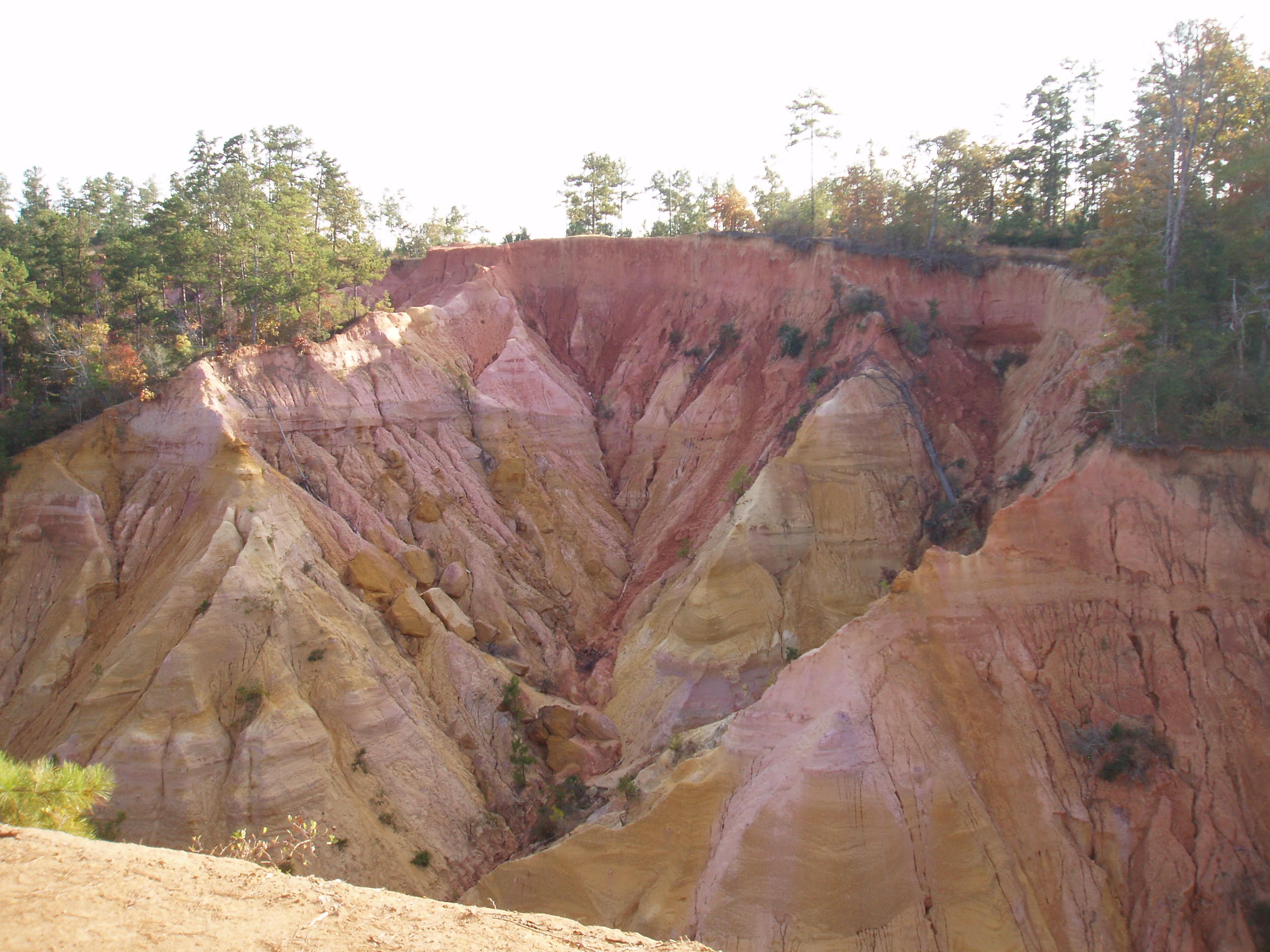
Red Bluff
Mississippi is supposed to be flat. That is the assumption, anyway -- a state of river bottoms and cotton fields and coastal marshes that barely rise above sea level. Then you come to a place in Marion County where the earth has simply fallen away. Red Bluff, known locally as Mississippi's Little Grand Canyon, is a geological wound on the west bank of the Pearl River: a jagged amphitheater of exposed red clay, amber sand, and streaked sediment plunging roughly 200 feet into the floodplain below. The bluff has swallowed portions of Mississippi Highway 587 at least twice, forcing road crews to reroute around a gap that grows by about a meter every year. It is the kind of place that makes you reconsider everything you thought you knew about this state.
Carved by Deep Time
The formation at Red Bluff is not the work of any river carving a canyon in the traditional sense. Geologists trace its origin to a hot spring that once jutted from the base of the Pearl River, destabilizing the elevated bank above and carving a small incision into the terrain. Over thousands of years, rain and runoff took over through a process called headward erosion -- water eating backward into the bluff face, widening and deepening the gash with every storm. The exposed walls reveal layers of sediment deposited during the Miocene and Pliocene epochs, a geological timeline painted in bands of iron-rich red clay, pale sand, and darker soils. Each color tells a chapter of an ancient story: changing climates, shifting riverbeds, and the slow accumulation of material that once lay at the bottom of a shallow sea.
A Canyon That Will Not Hold Still
What makes Red Bluff remarkable is that it is still actively growing. The erosion that created it has not stopped; if anything, it has accelerated. The bluff's edge creeps inland year after year, consuming trees, soil, and anything built too close. Mississippi Highway 587, which once ran along the bluff's rim, has been relocated multiple times as the ground beneath it crumbled away. An old road bed still dangles over the void in places, its asphalt cracked and tilting into empty air. The Pearl River carries away the fallen sediment, redistributing it downstream, a reminder that geology is not a finished process but an ongoing one. Visitors who return after a few years find a different landscape than the one they remember.
The View from the Edge
Standing at the rim of Red Bluff, the view sweeps across a significant portion of the Pearl River Basin in Marion County. To the east, the city of Columbia, Mississippi, is visible in the distance. Below, the floodplain spreads out in a patchwork of forest and water, the Pearl River winding through it all on its journey toward the Gulf of Mexico. The colors are what most visitors remember: vivid reds and burnt oranges at the bluff face, deep green canopy in every direction, and the gray-brown ribbon of the river below. The site sits about a mile and a half northwest of the small community of Morgantown, accessible by a short drive on local roads. There are no entrance fees, no gift shops, no visitor centers -- just a clearing at the edge of a precipice and 200 feet of open air.
Mississippi's Hidden Landmark
Red Bluff occupies an unusual place among America's natural wonders. It has none of the fame of the Grand Canyon or the tourist infrastructure of Providence Canyon State Park across the border in Georgia -- a similar erosion feature often compared to Red Bluff. What it has instead is solitude and strangeness, the uncanny experience of walking through Mississippi pine forest and arriving at a cliff face that looks like it belongs in the American Southwest. The exposed sediment bands draw geology enthusiasts, the dramatic overlook draws photographers, and the sheer improbability of the site draws everyone else. At roughly 371 feet above sea level, the bluff's rim is one of the higher points in this part of the state, offering a perspective on the Pearl River landscape that is impossible to get anywhere else.
From the Air
Red Bluff is located at approximately 31.33N, 89.95W, on the west bank of the Pearl River in Marion County, Mississippi, about 1.5 miles northwest of Morgantown. From altitude, look for a distinctive reddish-orange scar on the otherwise green landscape along the Pearl River's western bank. The exposed bluff face contrasts sharply with the surrounding forest canopy. The city of Columbia, Mississippi, is visible to the east. Nearest airports: Columbia-Marion County Airport (0R4) approximately 5nm east; Hattiesburg Bobby L. Chain Municipal Airport (KHBG) approximately 30nm northeast; Hattiesburg-Laurel Regional Airport (KPIB) approximately 40nm northeast. Best viewed at 1,500-3,000 feet AGL to appreciate the erosion feature's scale and coloring against the green river basin.