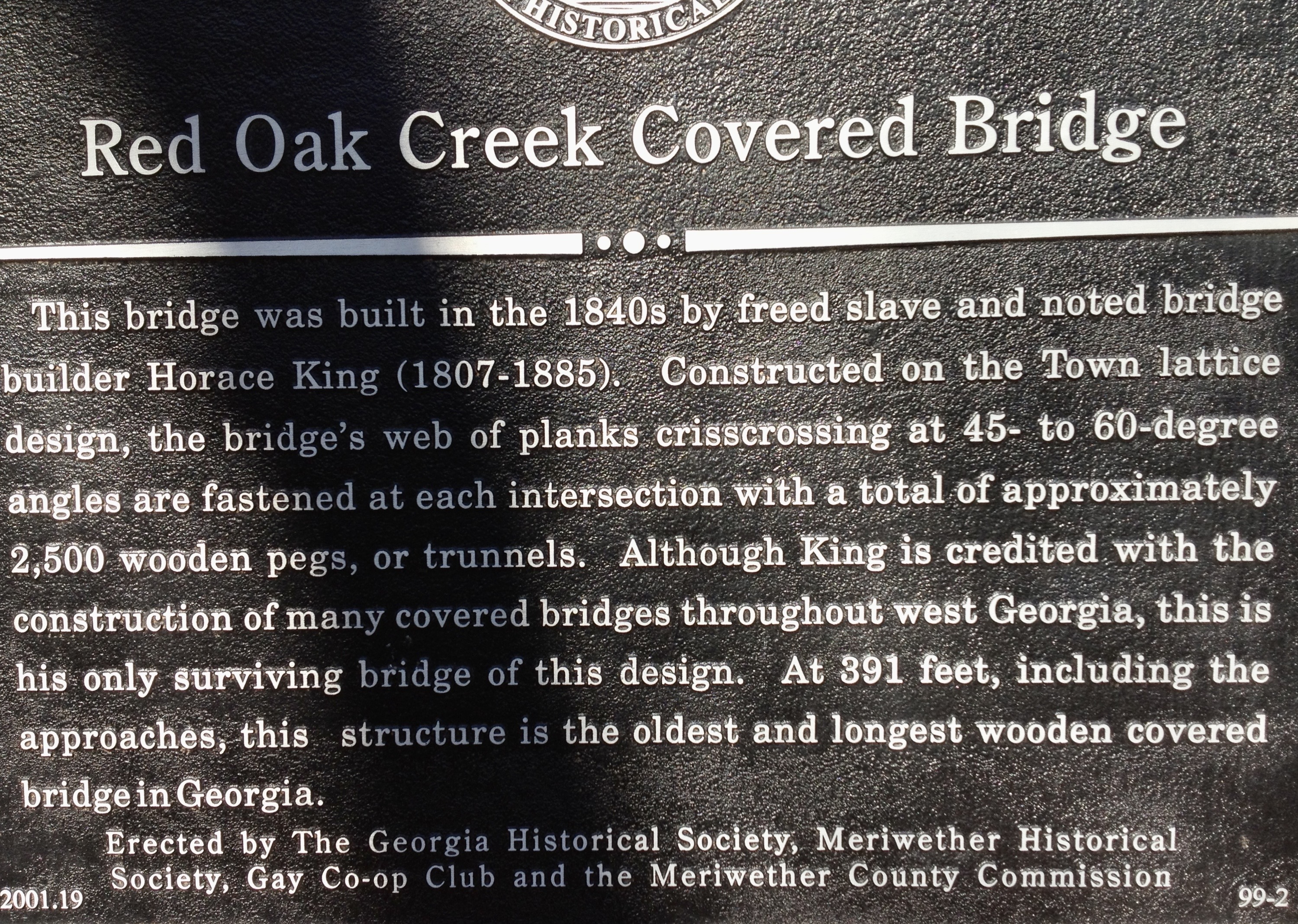
Red Oak Creek Covered Bridge
Exactly 2,500 wooden pegs hold the Red Oak Creek Covered Bridge together. No nails. No bolts. Just hand-carved trunnels driven into heart pine by the crew of Horace King, a man who was born into slavery in South Carolina in 1807 and became the most celebrated bridge builder in the Deep South. Spanning Red Oak Creek in the small community of Imlac, four miles north of Woodbury, Georgia, this bridge has carried traffic across these waters since the 1840s -- predating the Civil War, outlasting the age of covered bridges in Georgia, and standing as the sole surviving example of King's Town lattice design work.
The Builder Who Crossed Every Boundary
Horace King's story is as remarkable as the structures he left behind. Enslaved from birth, King was taught to read, write, and build by his enslaver, John Godwin. King's talent for engineering became so renowned that he constructed dozens of bridges across Georgia, Alabama, and Mississippi, earning a reputation as the finest bridge builder in the region. He gained his freedom and went on to serve in the Alabama state legislature during Reconstruction. Of the many covered bridges King built throughout west Georgia, the Red Oak Creek crossing is his only surviving bridge -- and his only known work using the Town lattice design, a pattern of diagonal planks crisscrossing at 45- to 60-degree angles that distributes weight through geometry rather than brute mass.
Heart Pine and Wooden Pegs
The bridge's construction reveals the craft of a master builder working with the materials at hand. Long sills sawn from heart pine -- the dense, resin-rich core of old-growth longleaf pines -- form the bridge's skeleton. The Town lattice web of overlapping planks creates a rigid structure without the heavy timber framing that other bridge designs require. Each intersection is fastened with a wooden trunnel, a peg shaped and driven tight enough to hold for generations. The covered portion stretches over the creek while the total span, including approaches, reaches 391 feet, making it the longest covered bridge in the state of Georgia. The roof and siding protect the structural timbers from rain and rot, the practical reason covered bridges were covered in the first place.
The Last of 250
When the Red Oak Creek Covered Bridge was added to the National Register of Historic Places in 1973, it was still carrying daily traffic -- and it was thought to be the oldest covered bridge in Georgia. The listing noted that it stood as "an outstanding reminder of the age when there were over 250 covered bridges in Georgia." That number has dwindled to a handful. Across the American South, covered bridges fell to floods, fires, neglect, and the march of concrete and steel. The Red Oak Creek bridge survived because it continued to serve a purpose. Covered Bridge Road, historically known as Huel Brown Road, still funnels local traffic across the creek, and the bridge remains open to vehicles today, carrying cars over the same timbers that once bore horse-drawn wagons.
A Bridge Worth Finding
The bridge sits in quiet Meriwether County, surrounded by the rolling piedmont landscape of west-central Georgia. Red Oak Creek meanders beneath the dark interior of the covered span, where the lattice framework casts diamond-shaped shadows on the wooden deck. Sometimes called the "Kissing Bridge" -- a nickname shared by covered bridges across America, since the enclosed crossing offered a moment of privacy for courting couples -- the structure draws photographers, history enthusiasts, and the occasional film crew. The bridge appeared in the 2012 film "Lawless." For most visitors, though, the real draw is simpler: standing inside a structure built by an extraordinary man nearly two centuries ago, listening to the creek below, and marveling that 2,500 wooden pegs still hold it all together.
From the Air
Located at 33.038N, 84.553W, four miles north of Woodbury in Meriwether County, Georgia. The covered bridge crosses Red Oak Creek and can be spotted from low altitude as a dark, elongated roofed structure over the waterway. Look for the creek winding through the wooded piedmont terrain and the cleared road approaches on either side. Best viewed below 2,000 feet AGL. The nearest airport is Thomaston-Upson County Airport (KOPN), approximately 15 nm to the southeast. Peach State Airport (K6A2) near Fort Valley is another option. The Flint River, running roughly north-south a few miles to the west, serves as a reliable visual navigation reference.