Reisa National Park
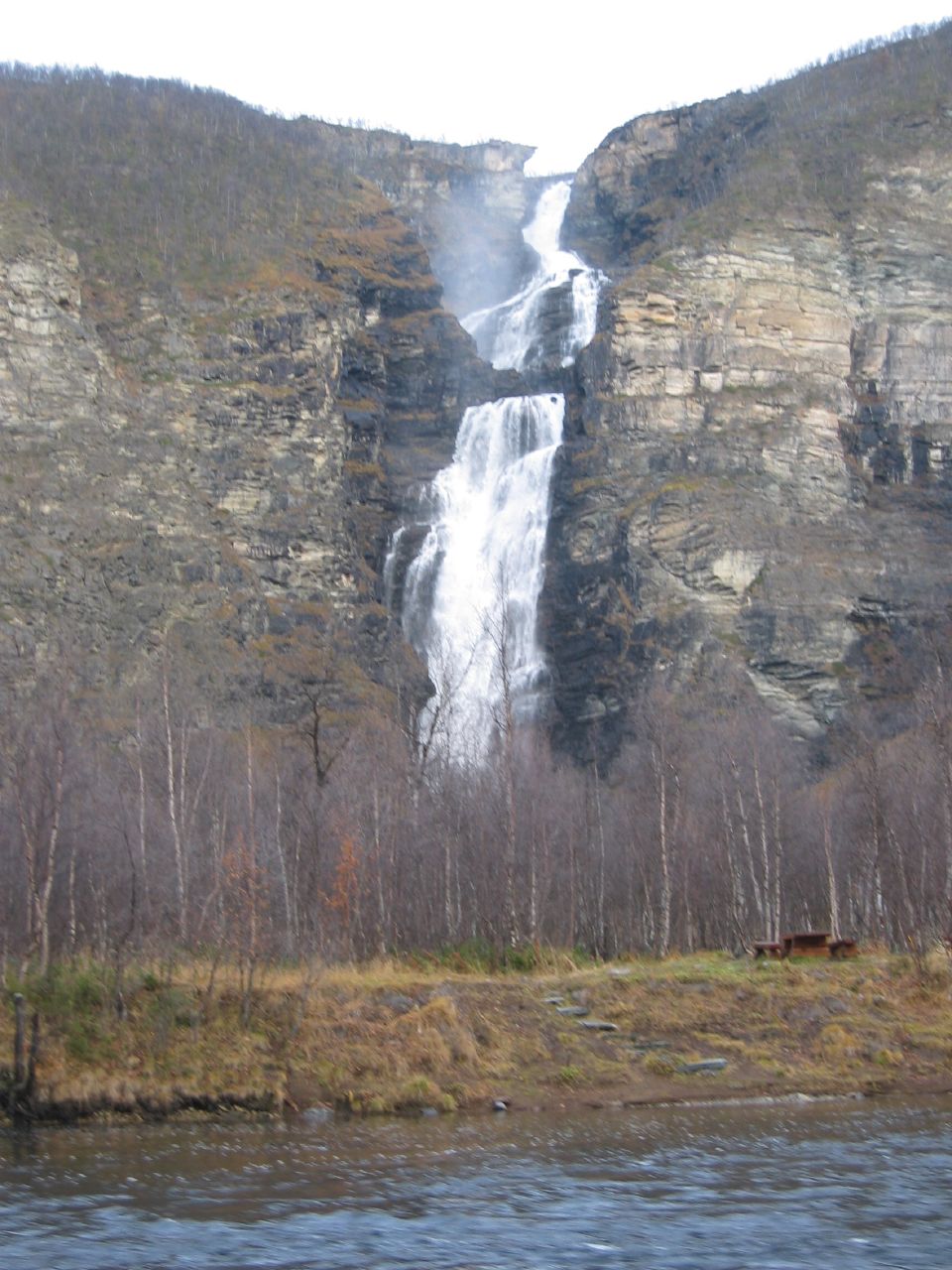
Mollisfossen announces itself long before you see it. The roar of water plunging 269 meters through a cleft in the bedrock carries up the Reisadalen valley, bouncing off canyon walls lined with pine and birch. At 69 degrees north, in the Arctic reaches of Troms county, Reisa National Park protects one of Norway's most dramatic river landscapes -- a place where the Reisa River has spent millennia carving a deep, forested gorge through the mountains, creating a world of waterfalls, ancient rock carvings, and wildlife that thrives at the edge of habitability.
The River That Built a Canyon
The Reisa River is the park's spine and sculptor. Over thousands of years it has cut a winding canyon through the landscape, flanked by dense boreal forest on the valley floor and barren mountain plateaus above. The most spectacular result is Mollisfossen, where the river drops 269 meters in a cascade with a single vertical plunge of 140 meters. Reaching it on foot is difficult -- the traditional approach is by riverboat, hired from local guides who navigate the river's twists with practiced ease. Upstream, the twin waterfalls of Imofossen mark the point where the Reisa plunges into an even narrower slot canyon, the spray rising like smoke from the rock. The river is also a renowned salmon stream, drawing anglers from across Scandinavia to fish for Atlantic salmon and Arctic char under strict permit regulations.
Traces on Stone
Long before Norway established this as a national park in 1986, people lived and moved through the Reisadalen valley. The Sami and Kven peoples left traces of their traditional cultures scattered across the landscape, but the most striking evidence of deep human history is at Sieimma, where ancient rock carvings mark a site of lasting cultural and spiritual significance. These petroglyphs connect the valley to the broader web of Arctic rock art found across northern Scandinavia, and they anchor the park's identity as more than a scenic wilderness. It is also a cultural landscape, shaped by the people who hunted, fished, and herded reindeer through these valleys for centuries before the concept of a national park existed.
Where Botanical Worlds Collide
Reisa National Park sits at a crossroads between different botanical zones, and the result is unusual biodiversity for a place this far north. Rich Scots pine forests line the valley floor, their canopy sheltering a surprisingly diverse understory. Higher up, the vegetation thins to hardy mountain scrub and lichen-crusted plateau. The park is home to Eurasian elk, wolverine, and lynx -- predators that require vast tracts of undisturbed habitat. Golden eagles patrol the thermals above the canyon rim, and gyrfalcons nest on the cliff faces, hunting ptarmigan across the open fells. In summer, when the subarctic sun barely dips below the horizon, the valley hums with insect life, and the birch forests flush vivid green against the grey rock.
Into the Arctic Wild
Getting into Reisa requires commitment. The gateway village of Storslett in Nordreisa municipality connects to the park via Route 865, which turns to gravel before reaching the trailhead at Saraelv. From there, marked trails lead into the valley, including a section of the Nordkalottruta -- the long-distance Arctic Trail that threads through the mountains of Norway, Sweden, and Finland. Hikers can camp almost anywhere under Norway's right-to-roam tradition, and the Norwegian Trekking Association maintains open and reservable cabins along the routes. But the terrain is demanding, the weather changes without warning even in July and August, and mobile phone coverage is unreliable. The Reisa River itself can be dangerous during spring snowmelt, when its flow surges through the narrow canyon with lethal force.
A Landscape of Extremes
The nearest airports at Tromsoe and Alta bracket the park to the west and east, while the small airstrip at Soerkjosen offers daily connections to both. From the air, the scale of the Reisadalen becomes clear: a dark green gash in a landscape of grey-brown mountain plateaus, the river glinting silver at its base. In winter, the canyon disappears under snow and the park becomes a world of cross-country skiing and dog sledding, the northern lights flickering above frozen waterfalls. In summer, packrafters and canoeists float the calmer stretches of the Reisa, their kayaks dwarfed by canyon walls that rise hundreds of meters on either side. It is a place that rewards effort and punishes carelessness in equal measure -- quintessentially Arctic, and profoundly Norwegian.
From the Air
Located at 69.20N, 21.97E in Troms county, northern Norway. The Reisadalen canyon is visible from altitude as a dark forested valley cutting through mountain plateaus. Nearest airports: Tromsoe (ENTC) to the southwest, Alta (ENAT) to the east, and Soerkjosen (ENSR) locally. Recommended viewing altitude 5,000-10,000 ft for canyon detail. The 269m Mollisfossen waterfall may be visible in clear conditions.